Difference between revisions of "Harare" - New World Encyclopedia
Mike Butler (talk | contribs) |
Mike Butler (talk | contribs) |
||
| Line 177: | Line 177: | ||
Harare is the site of the [[University of Zimbabwe]], the largest and most complete institution of higher learning in Zimbabwe, which is situated about 5km north of the city. Numerous suburbs surround the city, retaining the names colonial administrators gave them during the 19th century, such as [[Warren Park 'D']], [[Borrowdale, Harare|Borrowdale]], [[Mount Pleasant, Harare|Mount Pleasant]], [[Marlborough, Harare|Marlborough]], [[Tynwald, Harare|Tynwald]] and [[Avondale, Harare|Avondale]]. | Harare is the site of the [[University of Zimbabwe]], the largest and most complete institution of higher learning in Zimbabwe, which is situated about 5km north of the city. Numerous suburbs surround the city, retaining the names colonial administrators gave them during the 19th century, such as [[Warren Park 'D']], [[Borrowdale, Harare|Borrowdale]], [[Mount Pleasant, Harare|Mount Pleasant]], [[Marlborough, Harare|Marlborough]], [[Tynwald, Harare|Tynwald]] and [[Avondale, Harare|Avondale]]. | ||
| − | == | + | ==Geography== |
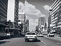
| − | [[Image: | + | [[Image:Harare.jpg|thumb|left|250px|Downtown Harare.]] |
| − | + | Etymology of name – if available. | |
| − | + | Topography: Physical qualities of a particular place. Example: Mexico City | |
| − | The | + | a. Mountain flanked basin |
| − | + | b. on dry lake bed | |
| − | + | c. vulnerability to earthquakes | |
| + | d. trapped air pollution (also true in L.A. and Athens) | ||
| + | Elevation | ||
| + | Climate (not required unless it makes the city a resort) | ||
| + | The city (Johannesburg) enjoys a dry, sunny climate, with the exception of occasional late afternoon downpours in the summer months of October to April. [[Temperature]]s are usually fairly mild due to the city's high altitude, with the average maximum daytime temperature in January of 79°F (26°C), dropping to an average maximum of around 61°F (16°C) in June. [[Winter]] is the sunniest time of the year, with cool days and cold nights. The temperature occasionally drops to below freezing at night, causing [[frost]]. [[Snow]] is rare. Mean annual precipitation is 28 inches (716mm). | ||
==Climate== | ==Climate== | ||
| − | |||
Harare has a pleasant and healthy climate. The average annual temperature is 17.95°C, rather low for the tropics, and this is due to its high altitude position and the prevalence of a cool south-easterly airflow.<ref>Average for years 1965-1995, Goddard Institute of Space Studies World Climate database</ref> There are three main seasons - a warm, wet season from November to March/April; a cool, dry season from May to August (corresponding to the Southern Hemisphere winter); and a hot, dry season in September/October. Daily temperature ranges are about 7°C to 20°C in July (coldest month), about 13°C to 28°C in October (hottest month) and about 15.5°C to 25°C in January (midsummer). The hottest year on record was 1914 - 19.73°C - and the coldest year was 1965 - 17.13°C. | Harare has a pleasant and healthy climate. The average annual temperature is 17.95°C, rather low for the tropics, and this is due to its high altitude position and the prevalence of a cool south-easterly airflow.<ref>Average for years 1965-1995, Goddard Institute of Space Studies World Climate database</ref> There are three main seasons - a warm, wet season from November to March/April; a cool, dry season from May to August (corresponding to the Southern Hemisphere winter); and a hot, dry season in September/October. Daily temperature ranges are about 7°C to 20°C in July (coldest month), about 13°C to 28°C in October (hottest month) and about 15.5°C to 25°C in January (midsummer). The hottest year on record was 1914 - 19.73°C - and the coldest year was 1965 - 17.13°C. | ||
The average annual rainfall is about 825mm in the south-west rising to 855mm on the higher land in the north-east (around Borrowdale to Glen Lorne). Very little rain usually falls during the period May to September although sporadic showers occur in most years. Rainfall varies a great deal from year to year and follows cycles of wet and dry periods that are from 7 to 10 years long. Records begin in October 1890 but all three Harare stations stopped reporting in early 2004. <ref>Global Historic Climate Network database NGDC</ref> | The average annual rainfall is about 825mm in the south-west rising to 855mm on the higher land in the north-east (around Borrowdale to Glen Lorne). Very little rain usually falls during the period May to September although sporadic showers occur in most years. Rainfall varies a great deal from year to year and follows cycles of wet and dry periods that are from 7 to 10 years long. Records begin in October 1890 but all three Harare stations stopped reporting in early 2004. <ref>Global Historic Climate Network database NGDC</ref> | ||
| Line 192: | Line 195: | ||
The climate supports a natural vegetation of open woodland. The most common tree of the local region is the Msasa [[Brachystegia spiciformis]] that colours the landscape wine-red with its new leaves in late August. An introduced tree that contributes most to the town's atmosphere is the [[Jacaranda]] (a South American species) that produces a burst of lilac when it blooms in September. | The climate supports a natural vegetation of open woodland. The most common tree of the local region is the Msasa [[Brachystegia spiciformis]] that colours the landscape wine-red with its new leaves in late August. An introduced tree that contributes most to the town's atmosphere is the [[Jacaranda]] (a South American species) that produces a burst of lilac when it blooms in September. | ||
| − | + | Rivers and canals | |
| − | + | Size – land area, size comparison | |
| − | + | Environmental issues | |
| − | + | Districts | |
| − | + | ==History== | |
| − | |- | + | [[Image:Salisbury in 1930.jpg|left|thumb|300px|Salisbury in 1930]] |
| − | + | [[Pioneer Column]], a military volunteer force of settlers organised by [[Cecil Rhodes]], founded the city in 1890 as a fort. They originally named the city Fort Salisbury after the [[Robert Arthur Talbot Gascoyne-Cecil, 3rd Marquess of Salisbury|3rd Marquess of Salisbury]], then [[British prime minister]], and it subsequently became known simply as Salisbury. It was declared to be a municipality in 1897 and it became a city in 1935. Salisbury was the capital of the [[Federation of Rhodesia and Nyasaland]] from 1953 to 1963. After that point, it was the capital of [[Southern Rhodesia]]. The government of [[Ian Smith]] declared Rhodesia independent of Great Britain on [[November 11]], [[1965]], and proclaimed the [[Republic of Rhodesia]] in 1970. Subsequently, the nation became the short-lived state of [[Zimbabwe Rhodesia]]; it was not until [[April 18]], [[1980]], that the country was internationally recognized as independent as the [[Republic of Zimbabwe]]. The capital city retained the name Salisbury until 1982. | |
| − | |||
| − | | | + | The name of the city was changed to Harare on [[April 18]], [[1982]], the second anniversary of Zimbabwean independence, taking its name from the [[Shona people|Shona]] chieftain Neharawa. It is also said the name derived from the European corruption of "Haarari" ("He does not sleep"), the epithet of the chief whose citadel was located in the area known today as the Kopje (pronounced "Koppie"). It was said that no enemy could ever launch a sneak attack on him. Prior to independence, "Harare" was the name of the Black residential area now known as Mbare. |
| − | |||
| − | |||
| − | + | The area at the time of founding of the city was poorly drained and earliest development was on sloping ground along the left bank of a stream that is now the course of a trunk road (Julius Nyerere Way). The first area to be fully drained was near the head of the stream and was named Causeway as a result. This area is now the site of many of the most important Government buildings, including the Senate House and the Office of the Prime Minister (now renamed for the use of President Mugabe after the position was abolished in January 1988.)<ref>Journal of Frederick Courtney Selous, Rhodesiana Reprint Library, Salisbury, 1969</ref> | |
| − | |||
| − | |||
| − | |||
| − | |||
| − | |||
| − | |||
| − | |||
| − | |||
| − | |||
| − | |||
| − | |||
| − | |||
| − | |||
| − | |||
| − | |||
==Notable landmarks and institutions== | ==Notable landmarks and institutions== | ||
Revision as of 07:07, 25 November 2008
| Harare, Zimbabwe | |||
 |
|||
|
|||
| Nickname: H Town | |||
| Motto: Pamberi Nekushandria Vanhu (Forward with Service to the People) | |||
 |
|||
| Coordinates: {{#invoke:Coordinates|coord}}{{#coordinates:17|51|50|S|31|1|47|E|type:city | |||
|---|---|---|---|
| name= }} | |||
| Country | Zimbabwe | ||
| Province | Harare | ||
| Founded | 1890 | ||
| Incorporated (city) | 1935 | ||
| Government | |||
| - Mayor | Muchadeyi Masunda | ||
| Elevation [1] | 1,490 m (4,888 ft) | ||
| Population (2006) | |||
| - City | 1,600,000 | ||
| - Urban | 2,800,111 | ||
| estimated | |||
| Time zone | CAT (UTC+2) | ||
| - Summer (DST) | CEST (UTC+1) | ||
| Twin Cities | |||
| - Nottingham | United Kingdom | ||
| - Munich | Germany | ||
| - Cincinnati | United States | ||
| - Prato | Italy | ||
| - Lago | Italy | ||
| Website: http://www.hararecity.co.zw | |||


Harare (pronounced /həˈrɑreɪ/ or /həˈrɑri/, formerly Salisbury) is the capital of Zimbabwe. It has an estimated population of 1,600,000, with 2,800,000 in its metropolitan area (2006). Administratively, Harare is an independent city equivalent to a province. It is Zimbabwe's largest city and its administrative, commercial, and communications centre. The city is a trade centre for tobacco, maize, cotton, and citrus fruits. Manufactures include textiles, steel, and chemicals, and gold is mined in the area. Harare is situated at an elevation of 1483 metres (4865 feet) and its climate falls into the warm temperate category.
Harare is the site of the University of Zimbabwe, the largest and most complete institution of higher learning in Zimbabwe, which is situated about 5km north of the city. Numerous suburbs surround the city, retaining the names colonial administrators gave them during the 19th century, such as Warren Park 'D', Borrowdale, Mount Pleasant, Marlborough, Tynwald and Avondale.
Geography

Etymology of name – if available. Topography: Physical qualities of a particular place. Example: Mexico City a. Mountain flanked basin b. on dry lake bed c. vulnerability to earthquakes d. trapped air pollution (also true in L.A. and Athens) Elevation Climate (not required unless it makes the city a resort) The city (Johannesburg) enjoys a dry, sunny climate, with the exception of occasional late afternoon downpours in the summer months of October to April. Temperatures are usually fairly mild due to the city's high altitude, with the average maximum daytime temperature in January of 79°F (26°C), dropping to an average maximum of around 61°F (16°C) in June. Winter is the sunniest time of the year, with cool days and cold nights. The temperature occasionally drops to below freezing at night, causing frost. Snow is rare. Mean annual precipitation is 28 inches (716mm).
Climate
Harare has a pleasant and healthy climate. The average annual temperature is 17.95°C, rather low for the tropics, and this is due to its high altitude position and the prevalence of a cool south-easterly airflow.[2] There are three main seasons - a warm, wet season from November to March/April; a cool, dry season from May to August (corresponding to the Southern Hemisphere winter); and a hot, dry season in September/October. Daily temperature ranges are about 7°C to 20°C in July (coldest month), about 13°C to 28°C in October (hottest month) and about 15.5°C to 25°C in January (midsummer). The hottest year on record was 1914 - 19.73°C - and the coldest year was 1965 - 17.13°C. The average annual rainfall is about 825mm in the south-west rising to 855mm on the higher land in the north-east (around Borrowdale to Glen Lorne). Very little rain usually falls during the period May to September although sporadic showers occur in most years. Rainfall varies a great deal from year to year and follows cycles of wet and dry periods that are from 7 to 10 years long. Records begin in October 1890 but all three Harare stations stopped reporting in early 2004. [3]

The climate supports a natural vegetation of open woodland. The most common tree of the local region is the Msasa Brachystegia spiciformis that colours the landscape wine-red with its new leaves in late August. An introduced tree that contributes most to the town's atmosphere is the Jacaranda (a South American species) that produces a burst of lilac when it blooms in September.
Rivers and canals Size – land area, size comparison Environmental issues Districts
History

Pioneer Column, a military volunteer force of settlers organised by Cecil Rhodes, founded the city in 1890 as a fort. They originally named the city Fort Salisbury after the 3rd Marquess of Salisbury, then British prime minister, and it subsequently became known simply as Salisbury. It was declared to be a municipality in 1897 and it became a city in 1935. Salisbury was the capital of the Federation of Rhodesia and Nyasaland from 1953 to 1963. After that point, it was the capital of Southern Rhodesia. The government of Ian Smith declared Rhodesia independent of Great Britain on November 11, 1965, and proclaimed the Republic of Rhodesia in 1970. Subsequently, the nation became the short-lived state of Zimbabwe Rhodesia; it was not until April 18, 1980, that the country was internationally recognized as independent as the Republic of Zimbabwe. The capital city retained the name Salisbury until 1982.
The name of the city was changed to Harare on April 18, 1982, the second anniversary of Zimbabwean independence, taking its name from the Shona chieftain Neharawa. It is also said the name derived from the European corruption of "Haarari" ("He does not sleep"), the epithet of the chief whose citadel was located in the area known today as the Kopje (pronounced "Koppie"). It was said that no enemy could ever launch a sneak attack on him. Prior to independence, "Harare" was the name of the Black residential area now known as Mbare.
The area at the time of founding of the city was poorly drained and earliest development was on sloping ground along the left bank of a stream that is now the course of a trunk road (Julius Nyerere Way). The first area to be fully drained was near the head of the stream and was named Causeway as a result. This area is now the site of many of the most important Government buildings, including the Senate House and the Office of the Prime Minister (now renamed for the use of President Mugabe after the position was abolished in January 1988.)[4]
Notable landmarks and institutions
- CBZ Holdings
- Cairns Holdings
- Data Control & Systems
- Dynamos F.C.
- Gwanzura
- 44 Harvest House
- Mbare Musika
- Mushandirapamwe Hotel
- National Gallery of Zimbabwe
- Net*One
- Parirenyatwa Hospital
- Reserve Bank of Zimbabwe
- Roman Catholic Archdiocese of Harare
- Rufaro Stadium
- Sam Nujoma Street
- St. John's College, Harare
- University of Zimbabwe
- Queen Victoria Museum
- Zimbabwe Stock Exchange
- Zimbabwe grounds
- Zimbabwe Museum of Human Sciences
- National Sport Stadium
- Heroes Acre
- Borrowdale Race Course
- Sam Levy Village
- Eastgate
- Westgate
- Zanu Pf Headquarters
- KG6
Business Companies
- Tawacom Group Zim Ltd
- Zimbabwe Groceries
- OK Chain stores
- TM Supermarkets
- Spar Supermarkets
- Lucky Seven Stores
- Boldcut Pvt Ltd
Banks
- CBZ Holdings
- Kingdom Financial Holdings
Transport Companies
- Munenzva Bus Service
- Blue Arrow
- Makarichi Tours
- Nyawo Tours
Primary Schools
- Glen- View 1 primary
- Glen- View 2 primary
- Glen- View 3 primary
- Glen- View 4 primary
- Glen- View 5 primary
- Glen- View 6 primary
- Glen- View 7 primary
- Glen- View 8 primary
- Budiriro 1 primary
- Budiriro 2 primary
- Budiriro 3 primary
- Budiriro 4 primary
- Budiriro 5 primary
- Zuvarabuda
- Admiral Tait Primary School
- Ardbennie Primary School
- Allan Wilson High School
- Arundel School
- Bishopslea School
Secondary Schools
- Glen- View 2 High
International Venue
Harare has been the location of several international summits such as the 8th Summit of the Non-Aligned Movement (6 September 1986) and Commonwealth Heads of Government Meeting (1991). The latter produced the Harare Declaration, dictating the membership criteria of the Commonwealth. In 1995, Harare hosted most of the 6th All-Africa Games, sharing the event with other Zimbabwean cities such as Bulawayo and Chitungwiza.
Transport

The public transport system of buses, run by ZUPCO has crumbled in recent years. Instead there has been a proliferation of privately owned companies that operate commuter omnibuses. With the advent of the fuel crisis in the country, the government introduced commuter trains in order to ease transport shortages.
Harare International Airport serves Harare. The National Railways of Zimbabwe, NRZ operate a daily overnight passenger train service that runs from Harare to Mutare and another one from Harare to Bulawayo.
News & information
Residents are exposed to a variety of sources for information, though almost all of their sources are controlled by the government. In the print media, there is the Herald, Financial Gazette, Independent, Standard, and Kwayedza. Since there has been an explosion of online media outlets. These include ZimOnline, ZimDaily, Guardian, NewZimbabwe, Times, Harare Tribune, Zimbabwe Metro and many others. The government controls all the electronic media, though Voice of America, Voice of the people and SW Radio Africa beam broadcasts into the country occasionally.
Recent developments
In the early 21st century Harare has been adversely affected by the political and economic crisis that is currently plaguing Zimbabwe, after the contested 2002 presidential election and 2005 parliamentary elections. The elected council was replaced by a government-appointed commission for alleged inefficiency, but essential services such as rubbish collection and street repairs have rapidly worsened, and are now virtually non-existent. In May 2006 the Zimbabwean newspaper the Financial Gazette, described the city in an editorial as a "sunshine city-turned-sewage farm".[5]
In May 2005 the Zimbabwean government demolished shantytowns in Harare and the other cities in the country in Operation Murambatsvina (Operation "Drive Out Trash"). This caused a sharp reaction in the international community because it took place without prior warning and no advance plans were made to provide alternative housing. It was widely alleged that the true purpose of the campaign was to punish the urban poor for supporting the opposition Movement for Democratic Change and to reduce the likelihood of mass action against the government by driving people out of the cities. The government claimed it was necessitated by a rise of criminality and disease.
This was followed by Operation Chikerema (Operation "Better Living") a year later which consisted of building concrete housing. Critics however, stated that these were inadequate citing the lack of electricity, plumbing or other infrastructure in poorly accessible areas.
Image gallery
- Harare secondst.jpg
Sam Nujoma Street, view south
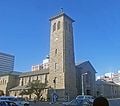
Anglican cathedral
- Harare Africa Unity.jpg
African Unity Square (formerly Cecil Square)
Downtown Harare, Reserve Bank ahead
- Harare Skyline.jpg
Harare Skyline
Along parliament buildings
- Harare Central Station.jpg
Harare Central Station


See also
- Suburbs of Harare
- Place names in Zimbabwe
- Provinces of Zimbabwe
- Districts of Zimbabwe
ReferencesISBN links support NWE through referral fees
- ↑ Google Earth
- ↑ Average for years 1965-1995, Goddard Institute of Space Studies World Climate database
- ↑ Global Historic Climate Network database NGDC
- ↑ Journal of Frederick Courtney Selous, Rhodesiana Reprint Library, Salisbury, 1969
- ↑ Financial Gazette editorial of 17 May 2006 "Zimbabwe: It's Chombo's Fault" [1]
External links
Credits
New World Encyclopedia writers and editors rewrote and completed the Wikipedia article in accordance with New World Encyclopedia standards. This article abides by terms of the Creative Commons CC-by-sa 3.0 License (CC-by-sa), which may be used and disseminated with proper attribution. Credit is due under the terms of this license that can reference both the New World Encyclopedia contributors and the selfless volunteer contributors of the Wikimedia Foundation. To cite this article click here for a list of acceptable citing formats.The history of earlier contributions by wikipedians is accessible to researchers here:
The history of this article since it was imported to New World Encyclopedia:
Note: Some restrictions may apply to use of individual images which are separately licensed.