Difference between revisions of "Guatemala City" - New World Encyclopedia
Mike Butler (talk | contribs) |
Mike Butler (talk | contribs) |
||
| Line 125: | Line 125: | ||
==Economy== | ==Economy== | ||
| − | Guatemala is the most populous of the Central American countries with a GDP per capita roughly one-half that of Argentina, Brazil, and Chile. The agricultural sector accounts for about one-tenth of GDP, two-fifths of exports, and half of the labor force. Coffee, sugar, and bananas are the main products, with sugar exports benefiting from increased global demand for ethanol. The 1996 signing of peace accords, which ended 36 years of civil war, removed a major obstacle to foreign investment, and Guatemala since then has pursued important reforms and macroeconomic stabilization. | + | Guatemala is the most populous of the Central American countries with a GDP per capita ($5100 in 2007) roughly one-half that of Argentina, Brazil, and Chile. The agricultural sector accounts for about one-tenth of GDP, two-fifths of exports, and half of the labor force. Coffee, sugar, and bananas are the main products, with sugar exports benefiting from increased global demand for ethanol. The 1996 signing of peace accords, which ended 36 years of civil war, removed a major obstacle to foreign investment, and Guatemala since then has pursued important reforms and macroeconomic stabilization. |
Guatemala is heavily centralized. Transportation, communications, business, politics, and the most relevant urban activity take place in Guatemala City. There is only one highway that traverses the greater communities of the country. Some coastal towns are accessible only through the coast by boats. | Guatemala is heavily centralized. Transportation, communications, business, politics, and the most relevant urban activity take place in Guatemala City. There is only one highway that traverses the greater communities of the country. Some coastal towns are accessible only through the coast by boats. | ||
| Line 133: | Line 133: | ||
Per capita GDP, rank | Per capita GDP, rank | ||
Financial and business services sector | Financial and business services sector | ||
| − | |||
Tourism | Tourism | ||
| Line 142: | Line 141: | ||
*The newly renovated and expanded [[La Aurora International Airport]] lies in the southern part of the city and is the main gateway to the country. | *The newly renovated and expanded [[La Aurora International Airport]] lies in the southern part of the city and is the main gateway to the country. | ||
*Urban public transportation is provided solely by bus. Guatemala City does not have an efficient public transportation service, despite the many proposals and projects for the construction of a mass transit system. Although the construction of freeways and underpasses by the municipal government, as well as the establishment of the Department of Metropolitan Transit Police, PMT, has helped traffic flow in the city, the Guatemalan metropolitan area faces a growing transportation problem. However, a new project called [[Transmetro]], consisting of special-purpose lanes for high-capacity buses, began operating in 2007 and aims to improve traffic flow in the city.[http://transmetro.muniguate.com/] | *Urban public transportation is provided solely by bus. Guatemala City does not have an efficient public transportation service, despite the many proposals and projects for the construction of a mass transit system. Although the construction of freeways and underpasses by the municipal government, as well as the establishment of the Department of Metropolitan Transit Police, PMT, has helped traffic flow in the city, the Guatemalan metropolitan area faces a growing transportation problem. However, a new project called [[Transmetro]], consisting of special-purpose lanes for high-capacity buses, began operating in 2007 and aims to improve traffic flow in the city.[http://transmetro.muniguate.com/] | ||
| − | |||
== Demographics == | == Demographics == | ||
Revision as of 21:23, 24 November 2008
| Guatemala City La Nueva Guatemala de la Asunción |
|
| Guatemala City | |
| Nickname: Guate | |
| Motto: "Tu eres la ciudad" (You are the city) | |
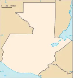
| Location within Guatemala | |
| Coordinates: {{#invoke:Coordinates|coord}}{{#coordinates:14|37|22.48|N|90|31|53.33|W|type:city | |
|---|---|
| name= }} | |
| Country | |
| Department | Guatemala |
| Municipality | Guatemala |
| Established | 1773 |
| Government | |
| - Mayor | Álvaro Arzú |
| Area | |
| - Total | 692 km² (267.2 sq mi) |
| - Land | 1,905 km² (735.5 sq mi) |
| Elevation | 1,500 m (4,921 ft) |
| Population (2008) | |
| - Total | 7,156,000 |
| Time zone | GMT-6 (UTC-6) |
| Website: Municipalidad de Guatemala | |
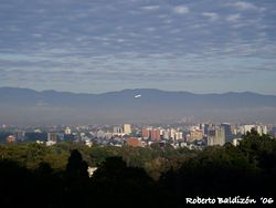
Guatemala City (in full, La Nueva Guatemala de la Asunción; locally known as Guatemala or Guate) is the capital and largest city of the nation of Guatemala, and the largest city in Central America.
As of the 2006 census, the city had a population of 1,202,536 although it has grown in great amounts through the last two years. [1] The city is located at , in a mountain valley in the south central part of the country.
Geography
The origin of the name Guatemala is Indian, but its derivation and meaning are undetermined. Some hold that the name means land of the trees in the Maya-Toltec language.
Guatemala City is located in a valley of the central highlands at an elevation of 4897 feet (1493 metres) above sea level. The city has a temperate and invigorating mountain climate. The average maximum daytime temperature year-round is 86°F (30°C). Rainfall in Guatemala city varies from two inches to 57 inches a month (51mm to 1455mm).
Guatemala City has been rocked by earthquakes, the worst from 1917 to 1918, which shook the city for six weeks, and in 1976.
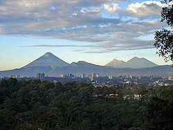
Four volcanoes are visible from the city, two of them active. The nearest and most active is Pacaya, which at times expels a considerable amount of ash, resulting in the closure of La Aurora International Airport and subsequent flight delays. [1]
Due to heavy rainfalls some of the humble neighborhoods built at the edge of steep valleys are frequently washed away and buried under mudslides, as in October 2005 [2].
In February 2007 a large sinkhole opened in a poor neighborhood in northeast Guatemala city, killing three people. The sinkhole was 330 feet (100 meters) deep, and apparently was created by fluid from a sewer dissolving the rock underneath. As a result, some 1000 people were evacuated from the area. [3] Districts
Guatemala City is subdivided into 25 zones, each zone with its own streets and avenues, making it easy to find addresses. However, the city has grown fast and has absorbed the neighboring towns of Villa Nueva, Santa Catarina Pinula, Mixco, and the suburban area of Carretera a El Salvador, which is a big commercial and residential part of the city.
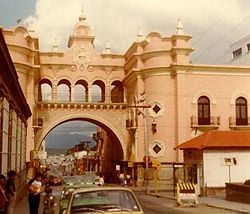
Zone One is the historic center, (Centro Histórico), lying in the very heart of the city, and is the location of many important buildings including the Palacio Nacional (National Palace), the Metropolitan Cathedral, the National Congress, the Casa Presidencial (Presidential House), the National Library and Central Park.
History
The first evidence of human settlers in Guatemala goes back to at least 12,000 B.C.E.
The Maya civilization dominated the region for nearly 2000 years before the Spanish arrived in the early 16th century, although most of the Great Classic Maya cities of the Petén region of Guatemala's northern lowlands were abandoned by the year 1000 C.E. The states of the central highlands, however, were still flourishing until the arrival of the Spanish Conquistador Pedro de Alvarado, who subjugated the native states, beginning in 1523.
In Spanish colonial times, Guatemala City was a small town. It had a monastery called 'El Carmen', founded in 1629. The capital of Spanish colonial Central America was moved there on January 2, 1776, after several earthquakes destroyed the old capital, Antigua Guatemala, in 1773-1774,
This region was not as rich in gold and silver as Mexico and Peru, and was therefore not considered to be as important. Its main products were sugarcane, cocoa, blue añil dye, red dye from cochineal insects, and precious woods used in artwork for churches and palaces in Spain.
On September 15, 1821, the Captaincy-general of Guatemala (formed by Chiapas, Guatemala, El Salvador, Nicaragua, Costa Rica, and Honduras) officially proclaimed its independence from Spain and its incorporation into the Mexican Empire. The city was the scene of the declaration.
The Captaincy-general of Guatemala was dissolved two years later. The Guatemalan provinces formed the United Provinces of Central America, also called the Central American Federation (Federacion de Estados Centroamericanos). Guatemala City served as the capital. That federation dissolved in civil war from 1838 to 1840.
José Rafael Carrera Turcios (1814-1865) was the first President of Guatemala, representing the Conservatives, on two occasions: from December 4, 1844, to August 16, 1848, and from November 6, 1851, to April 14, 1865.
Guatemala's "Liberal Revolution" came in 1871 under the leadership of Justo Rufino Barrios (1835–1885), who worked to modernize the country, improve trade, and introduce new crops and manufacturing. During this era coffee became an important crop for Guatemala.
The U.S.-based multinational United Fruit Company started becoming a major force in Guatemala in 1901, during the long presidencies of Manuel José Estrada Cabrera (1857–1923) and General Jorge Ubico (1878–14 June 1946). During the latter's dictatorship in the 1930s, Guatemala was further opened up to foreign investment, with special favours being made from Ubico to the United Fruit Company in particular. The company responded by pouring investment capital into the country, buying controlling shares of the railroad, electric utility, and telegraph, while also winning control of over 40 percent of the country's best land and de facto control over its only port.
During the second half of the 20th century, Guatemala experienced a variety of military and civilian governments, as well as a 36-year guerrilla war. In 1996, the government signed a peace agreement formally ending the conflict, which had left more than 100,000 people dead and had created, by some estimates, some one million refugees.
Government
Guatemala is a constitutional democratic republic, in which the president is both the chief of state and head of government, who is elected by popular vote for a four-year term, and may not serve consecutive terms. The unicameral Congress of the Republic has 158 members who are elected by popular vote to serve four-year terms. The president appoints a council of ministers.
Guatemala is divided into 22 departments (departamentos) and sub-divided into about 332 municipalities (municipios). Guatemala City is the capital city of, and a municipality within, the Guatemala Department.
Economy
Guatemala is the most populous of the Central American countries with a GDP per capita ($5100 in 2007) roughly one-half that of Argentina, Brazil, and Chile. The agricultural sector accounts for about one-tenth of GDP, two-fifths of exports, and half of the labor force. Coffee, sugar, and bananas are the main products, with sugar exports benefiting from increased global demand for ethanol. The 1996 signing of peace accords, which ended 36 years of civil war, removed a major obstacle to foreign investment, and Guatemala since then has pursued important reforms and macroeconomic stabilization.
Guatemala is heavily centralized. Transportation, communications, business, politics, and the most relevant urban activity take place in Guatemala City. There is only one highway that traverses the greater communities of the country. Some coastal towns are accessible only through the coast by boats.
Guatemala City is the economic, governmental and cultural capital of the Republic, and it functions as the main port of entry into the country, with the country's largest international airport, La Aurora International Airport. In addition to a wide variety of restaurants, hotels and shops, the city has a wide variety of art galleries and museums (including some fine collections of Pre-Columbian art) and continually offers an increasing amount of cultural activities.
Per capita GDP, rank Financial and business services sector
Tourism Manufacturing Transport: Road, rail, air, sea The city is a hub for Germany’s and Europe’s high-speed passenger rail network. Autobahns radiate from Cologne's ring road. Cologne's international airport is Cologne Bonn Airport, also called Konrad Adenauer Airport. The Rhine harbor is one of the larger inland ports in Germany. Public transport within the city includes buses, a subway system, and the Rheinseilbahn aerial tramway crossing the Rhine. Cologne has pavement-edge cycle lanes linked by cycle priority crossings.
- The newly renovated and expanded La Aurora International Airport lies in the southern part of the city and is the main gateway to the country.
- Urban public transportation is provided solely by bus. Guatemala City does not have an efficient public transportation service, despite the many proposals and projects for the construction of a mass transit system. Although the construction of freeways and underpasses by the municipal government, as well as the establishment of the Department of Metropolitan Transit Police, PMT, has helped traffic flow in the city, the Guatemalan metropolitan area faces a growing transportation problem. However, a new project called Transmetro, consisting of special-purpose lanes for high-capacity buses, began operating in 2007 and aims to improve traffic flow in the city.[4]
Demographics
The current population estimates for Guatemala City are about 7,156,000 in the greater metropolitan region.[2] Guatemala City's population continues to increase with the influx of predominantly indigenous migrants from the other departments as well as people from other countries coming to live to the city.
Guatemalans have a diversity of origins, with Spanish and Mestizo descent being the most common. There are also important Indigenous communities and smaller German, Jewish and Korean.
Language Religion
There are 10 universities, Universidad Mariano Gálvez, Universidad Panamericana, Universidad Mesoamericana, Universidad Rafael Landivar, Universidad Francisco Marroquin, Universidad del Valle, Universidad del Istmo, Universidad Galileo, Universidad Rural and Universidad de San Carlos, the only public one and third oldest university in America.
Of interest
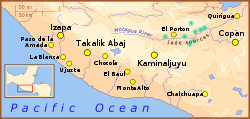
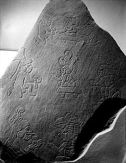
Within the confines of modern Guatemala City is the ancient Maya city of Kaminaljuyu. Kaminaljuyu dates back some 9000 years and is one of the Americas' most notable archaeological sites. The center of Kaminaljuyu was located a short distance from the oldest part of Guatemala City. However, in the late 20th century, the city grew around the ruins, and, in some cases, over some of the outlying ruins before they were protected. Many of the several hundred temple mounds have been built over with freeways, shopping centers, commerce, luxury hotels and residential areas. The central ceremonial center of Kaminaljuyu was protected by the Guatemalan government and is now a park within the city. Even so, there are some ruins still alive that are protected by the government.
Zone 1
- Railway Museum [5]
- Centro Histórico [6]
- National Palace (Guatemala) and Metropolitan Cathedral
- Mercado Central (central market)
- Biblioteca Nacional (national library)
Zone 2
- Mapa en Relieve (giant map of Guatemala) and surrounding parks [7]
Zone 4
- Centro Cultural Miguel Ángel Asturias
- Cuatro Grados Norte trendy pedestrian area
- Visa Immigration Office for all foreigners
Zone 7
- Kaminaljuyu and Museo Miraflores [8]
Zone 9
- Torre del Reformador tower
- Parque de la Industria, fairgrounds [9]
- Avenida Reforma and El Obelisco, a parklike boulevard
Zone 10
- Museo Ixchel del Traje Indígena (Mayan dress museum) [10]
- Museo Popol Vuh [11]
- Zona Viva entertainment district
- Botanical garden [12]
Zone 11
- Mcdonald's Utatlán which is one of the largest worldwide
Zone 13
- Museo de Arqueología y Etnología (archaeological museum) [13]
- La Aurora Zoo [14]
- La Aurora International Airport
Guatemala City possesses several sportsgrounds and is home to many sports clubs. Football is the most popular sport, with Comunicaciones, CSD Municipal, and Aurora FC being the main clubs. The Estadio Mateo Flores, located in the Zone 5 of the city, is the largest stadium in the country, followed in capacity by the Estadio Cementos Progreso and the Estadio del Ejército. An important multi-functional hall is the Domo Polideportivo de la CDAG.
The city has hosted several international sports events: in 1950 it hosted the VI Central American and Caribbean Games, and in 2000 the FIFA Futsal World Championship. On July 4, 2007 the International Olympic Committee gathered in Guatemala City and voted Sochi to become the host for the 2014 Winter Olympics.[15]
Guatemala City was announced in November 2007 to host the 2008 edition of the CONCACAF Futsal Championship, played at the Domo Polideportivo from June 2 to June 8 2008.[3][4]
ReferencesISBN links support NWE through referral fees
- ↑ Instituto Nacional de Estadística - Censo Nacional 2006, accessed 11 July 2007
- ↑ Varis, Olli , 'Megacities, Development and Water', International Journal of Water Resources Development, 22:2, 199 - 225
- ↑ 2008 CONCACAF Futsal Championship to take place in Guatemala. CONCACAF. Retrieved 2008-03-29.
- ↑ 2008 CONCACAF Futsal Championship Logo Unveiled. CONCACAF. Retrieved 2008-03-29.
See also
- 2007 Guatemala earthquake
- La Aurora International Airport
- Travel guide to Guatemala City from Wikitravel
External links
- Encyclopaedia Britannica Guatemala City Retrieved November 23, 2008.
- World Fact Book 2008 Guatemala Retrieved November 23, 2008.
- INGUAT
- Que Pasa in the City
Credits
New World Encyclopedia writers and editors rewrote and completed the Wikipedia article in accordance with New World Encyclopedia standards. This article abides by terms of the Creative Commons CC-by-sa 3.0 License (CC-by-sa), which may be used and disseminated with proper attribution. Credit is due under the terms of this license that can reference both the New World Encyclopedia contributors and the selfless volunteer contributors of the Wikimedia Foundation. To cite this article click here for a list of acceptable citing formats.The history of earlier contributions by wikipedians is accessible to researchers here:
The history of this article since it was imported to New World Encyclopedia:
Note: Some restrictions may apply to use of individual images which are separately licensed.
