Difference between revisions of "Seoraksan" - New World Encyclopedia
(Applied Category tags, checked spelling, applied Ready tag.) |
Anne Inoue (talk | contribs) (references) |
||
| Line 68: | Line 68: | ||
==References== | ==References== | ||
| + | |||
| + | *Yoo, Ki-Joon. 1996. ''Land spectrum model (LSM) based on resource values and recreation oppurtunities for the Korean National Park system a GIS-based case study in Sorak Mountain National Park'', Korea. OCLC: 35689149 | ||
| + | |||
<gallery> | <gallery> | ||
Revision as of 00:40, 18 November 2007
| Seoraksan | |
|---|---|

| |
| Korean Name | |
| Hangul | 설악산 |
| Hanja | 雪嶽山 |
| Revised Romanization | Seoraksan |
| McCune-Reischauer | SŏSeoraksan |
| Elevation: | 1,708 meters (5,603 feet) |
| Coordinates: | 37°45′N 128°29′E |
| Location: | South Korea |
| First ascent: | ??? |
| Easiest route: | hike, scramble |
Seoraksan is the highest mountain in the Taebaek mountain range in the Gangwon province in eastern South Korea. It is located in a national park near the city of Sokcho. After the Hallasan volcano on Jeju Island and Jirisan in the south, Seorak-san is the third highest mountain in South Korea. The Daechongbong Peak of Seoraksan reaches 1,708 meters (5,603 feet). The Taebaek mountain chain is often considered the backbone of the Korean peninsula.
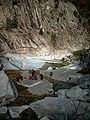
The national park attracts many national and international tourists all year round, but the main season for the Seoraksan national park is autumn. The autumn colors in the area are considered amongst the most beautiful in Korea. The red and yellow forest is interrupted by rocks and small mountain streams flow amidst this. During the rainy season in summer – especially after a typhoon – these streams can swell.
Perhaps the most visited part of the mountain is the main entrance valley to the National Park, fifteen minutes drive from Seokcho city. The valley runs west to east with a paved road leading up to the park's entrance gate. This valley contains many beautiful sites and is well worth a day visit.
The Yukdam waterfall and the Biryeong waterfall are located on the left side of the valley, about a forty minute walk from the main car park. Ulsanbawi is a rock formation in the Seoraksan national park. The shape of Ulsanbawi is unique in the area. To reach the rocks you need to follow a hiking path and climb over 800 steps. On the way there, there are two temples and a spherical rock (Heundeulbawi) which is located on top of a larger rock. This rock is about 5 meters (16 feet) high and can be moved with some effort. Thousands of people have already tried to push down Heundeulbawi, but nobody gets further than waggling the rock.
According to the legend Ulsanbawi comes from the city of Ulsan in the south east of Korea. As Kumgangsan was built, Ulsanbawi walked to the north as the representative of the city. Unfortunately Ulsanbawi arrived too late and there was no more room. Ulsanbawi was ashamed and slowly trudged back to the south. One evening the rock went to sleep in the Seorak area. Ulsanbawi felt it was so beautiful around there that it decided to stay for good.
At the end of the main valley is Biseondae, a rock platform in a stream. Above the stream is a difficult to reach cave, which offers amazing views of the surrounding rock formations.
Apart from the colors of the mountainous forest, the shapes of the rocks are attractive. A bit further away from the entrance is the Cheonbuldong valley. The name (Cheonbuldong) means 1000 Buddhas. Not much imagination is needed to see naturally built Buddha statues in the rocks that dominate the forest.
begin National Park paste—Daniel 19:44, 6 August 2007 (UTC)
[1] Seoraksan National Park, in Gangwon-do, 398.53 km². Sinheungsa[temple]. A monk named Jajangyulsa built Sinheungsa to the east of Norumok in the 6th year of Queen Jindeok (652)of Silla Dynasty. He also built the nine-story pagoda to enshrine the sarira of Buddha - he called it "Hyangseongsa." Later, Hyangseongsa was moved to the present site, and given the new name, "Sinheungsa" during the reign of King Injo of the Joseon Dynasty. In the precincts, Geugnakbojeon, Bojeru, Gyeongpan, Myeongbujeon, and Hyangseongsaji three-story pagoda have been preserved. Visitors can also see the attached temples, Gyejoam, Naewonam, Anyangam and Geumganggul(cave). This temple has 40 branch temples in the northern part of Gangwondo province.
Gwongeumseong. There are high rocks, called Gwongeum-seong, to the south of Sogongwon. It takes 8 minutes to travel to Gwongeumseong (12km), by cable car. On the cable station, you will see the magnificent Ulsanbawi (rock). At the top, East Sea and Sokcho city can be seen at a glance. Looking west, you will see an exquisite cliffs, such as Gongnyongneungseon (Dragon Ridge line), Cheonhwadae, Madeungnyeong, and Jeohangnyeong. Gwongeumseong is named after two men, Mr. Kim and Kwon, who built it to hide themselves from war.
Baekdamsa [Temple]. A monk named Jajangyulsa built Baekdamsa, one of the representative temples of Nae(Inner) Seorak. It was named "Hangyesa" during the reign of Queen Jindeok (647) of Silla. However, its name was changed several times, and it was rebuilt after being destroyed by fire. Baekdamsa was named during the rein of King Sejo of the Joseon Dynasty. The temple gained widespread fame because Han Yongun, a prominent poet, decided to enter the Buddhist priesthood in this temple.
end import National Park Service—Daniel 19:44, 6 August 2007 (UTC)
end National Park paste
See also
- Mt. Seoraksan Nature Reserve
- List of Korea-related topics
- List of mountains in Korea
- Geography of South Korea
ReferencesISBN links support NWE through referral fees
- Yoo, Ki-Joon. 1996. Land spectrum model (LSM) based on resource values and recreation oppurtunities for the Korean National Park system a GIS-based case study in Sorak Mountain National Park, Korea. OCLC: 35689149
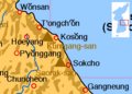
Location of Seoraksan]]
- Korea-Seoraksan-Buddha-Statue-01.jpg
Large Budda statue at main entrance to Seoraksan National Park.
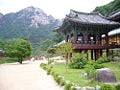
Temple in Seoraksan National Park.
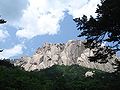
Ulsanbawi
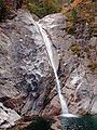
Biryong waterfall.
- Ulsanbawi.jpg
Ulsanbawi, Seoraksan.
비선대
울산바위


Credits
New World Encyclopedia writers and editors rewrote and completed the Wikipedia article in accordance with New World Encyclopedia standards. This article abides by terms of the Creative Commons CC-by-sa 3.0 License (CC-by-sa), which may be used and disseminated with proper attribution. Credit is due under the terms of this license that can reference both the New World Encyclopedia contributors and the selfless volunteer contributors of the Wikimedia Foundation. To cite this article click here for a list of acceptable citing formats.The history of earlier contributions by wikipedians is accessible to researchers here:
The history of this article since it was imported to New World Encyclopedia:
Note: Some restrictions may apply to use of individual images which are separately licensed.