Orinoco River
| Orinoco | |||
|---|---|---|---|
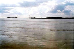
Bridge over the Orinoco at Ciudad Bolívar, Venezuela
| |||
| Countries | Venezuela, Colombia | ||
| Length | 2,410 km (1,498 miles) | ||
| Watershed | 880,000 km² (339,770 miles²) | ||
| Discharge | mouth | ||
| - average | 33,000 meters³/sec. (1,165,384 feet³/sec.) | ||
| Source | |||
| - location | Cerro Delgado-Chalbaud, Parima, Venezuela + Brazil | ||
| - coordinates | coord}}{{#coordinates:02|19|05|N|63|21|42|W|landmark | name=
}} | |
| - elevation | 1,047 meters (3,435 feet) | ||
| Mouth | Delta Amacuro | ||
| - location | Atlantic Ocean, Venezuela | ||
| - elevation | 0 meters (0 feet) | ||
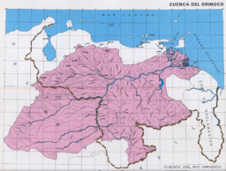
The Orinoco is one of the longest rivers in South America at 2,410 km, (1,497.5 miles). Its drainage basin, sometimes called the Orinoquia (especially in Colombia) covers 880,000 km², 76.3% in Venezuela with the rest in Colombia. The Orinoco and its tributaries are the major transportation system for eastern and interior Venezuela and the llanos of Colombia. However, since river navigation is declining in every country, many of the old waterways along the Orinoco watershed are now an obstacle to land communications more than a useful commercial route.
Geography
The Orinoco course describes a wide ellipsoidal arc, surrounding the Guiana Shield; it is divided in four stretches of unequal length that roughly correspond to the longitudinal zonation of a typical large river:
- Upper Orinoco, 242 km long, from its headwaters to the rapids Raudales de Guaharibos, flows through mountainous landscape in a northwesterly direction
- Middle Orinoco, 750 km long, divided into two sectors, the first of which ca. 480 km long has a general westward direction down to the confluence with the Atabapo and Guaviare rivers at San Fernando de Atabapo; the second flows northward, for about 270 km, along the Venezuelan - Colombian border, flanked on both sides by the westernmost granitic upwellings of the Guiana Shield which impede the development of a flood plain, to the Atures rapids near the confluence with the Meta River at Puerto Carreño,
- Lower Orinoco, 959 km long with a well developed alluvial plain, flows in a Northeast direction, from Atures rapids down to Piacoa in front of Barrancas
- Delta Amacuro, 200 km long that empties into the Gulf of Paría and the Atlantic Ocean, a very large delta (some 22.500 km² and 370 km at its widest).
At its mouth it forms a wide delta that branches off into hundreds of rivers and waterways that flow through 41,000 km² of swampy forests. In the rainy season the Orinoco can swell to a breadth of 22 kilometres and a depth of 100 meters.
Most of the important Venezuelan rivers are tributaries of the Orinoco, the largest being the Caroní, which joins it at Puerto Ordaz, close to the Llovizna Falls. A peculiarity of the Orinoco river system is the Casiquiare canal, which starts as an arm of the Orinoco, and finds its way to the Rio Negro, a tributary of the Amazon, thus forming a 'natural canal' between Orinoco and Amazon.
Major rivers in the Orinoco Basin
- Apure: from Venezuela through the east into the Orinoco
- Arauca: from Colombia to Venezuela east into the Orinoco
- Atabapo: from the Guiana Highlands of Venezuela north into the Orinoco
- Caroní: from the Guiana Highlands of Venezuela north into the Orinoco
- Casiquiare canal: in SE Venezuela, a distributary from the Orinoco flowing west to the Negro River, a major afluent to the Amazon
- Caura: from eastern Venezuela (Guiana Highlands) north into the Orinoco
- Guaviare: from Colombia east into the Orinoco
- Inírida: from Colombia northeast into the Guaviare.
- Meta: from Colombia, border with Venezuela east into the Orinoco
- Ventuari: from eastern Venezuela (the Guiana Highlands) southwest into the Orinoco
- Vichada: from Colombia east into the Orinoco
Ecology
The Boto, or Amazon River Dolphin, is also known to inhabit the Orinoco River system.
The Orinoco Crocodile is one of the rarest reptiles in the world, with fewer than 250 specimens remaining in the wild. Its present-day range in the wild is restricted to the Orinoco River Basin.
The Orinoco is home to the Caribe Piranha or Pygocentrus cariba. It is the most aggressive piranha of the Characidae family.[citation needed]
History
Although the mouth of the Orinoco in the Atlantic Ocean was discovered by Columbus on his third voyage (1498-08-01), its source at the Cerro Delgado-Chalbaud, in the Parima range, on the Venezuelan-Brazilian border, at 1,047 m of elevation ({{#invoke:Coordinates|coord}}{{#coordinates:02|19|05|N|63|21|42|W| | |name= }} ), was only explored in 1951, 453 years later, by a joint Venezuelan-French team.
The delta of the Orinoco, and tributaries in the eastern llanos such as the Apure and Meta, were explored in the 16th Century by German expeditions under Ambrosius Ehinger and his successors. In 1531 Diego de Ordaz, starting at the principal outlet in the delta, the Boca de Navios, sailed up the river to the Meta, and Antonio de Berrio sailed down the Casanare, to the Meta, and then down the Orinoco and back to Coro.
Alexander von Humboldt explored the basin in 1800, reporting on the pink river dolphins, and publishing extensively on the flora and fauna.[1]
Economic activity
The river is navigable for most of its length, and dredging enables ocean ships to go as far as Ciudad Bolívar, the conflence of the Caroní River, 435 km upstream. River steamers carry cargo as far as Puerto Ayacucho and the Atures Rapids.
The Orinoco river deposits also contains extensive tar sands in the Orinoco oil belt, which may be a source of future oil production.[2]
Trivia
The song Orinoco Flow by Irish singer Enya is often mistakingly thought to be named after the Orinoco, but in fact it was named after the studio in which it was recorded.
Robinson Crusoe (a fictional character created by Daniel Defoe) was stranded on an island near the mouth of the Orinoco river on September 30, 1659.[1]
The 1982 Doctor Who episode "Black Orchid", set in 1925, involved a botanist-explorer who reportedly went missing during one of his trips down the Orinoco river, where he had previously acquired the titular orchid.
In W.H. Hudson's Green Mansions, Mr. Abel followed the Orinoco to discover Rima, his bird-girl.
The city of Guayana, and the Alcaldia Mayor de Caroní (ALMACARONÍ) has for the past 15 years conducted a swim race of the rivers Orinoco and Caroní with around 900 competitors. The "Paso a Nado Internacional de los Rios Orinoco-Caroní" is celebrated every year on a Sunday close to April 19. Worldwide, this swim-meet has gained importance and it has a large number of competitors.
Notes
- ↑ Helferich. Gerard (2004) Humboldt's cosmos : Alexander von Humboldt and the Latin American journey that changed the way we see the world Gotham Books, New York, ISBN 1-59240-052-3 ;
- ↑ Forero, Juan (1 June 2006) "For Venezuela, A Treasure In Oil Sludge" New York Times Vol. 155 Issue 53597, pC1-C6;
ReferencesISBN links support NWE through referral fees
- Stark, James H. 1897. Stark's Guide-Book and History of Trinidad including Tobago, Granada, and St. Vincent; also a trip up the Orinoco and a description of the great Venezuelan Pitch Lake. Boston, James H. Stark, publisher; London, Sampson Low, Marston & Company. (This book has an excellent description of a trip up the Orinoco as far as Ciudad Bolivar and a detailed description of the Venezuelan Pitch Lake situated on the western side of the Gulf of Paria opposite.)
- MacKee, E.D., Nordin, C.F. and D. Perez-Hernandez (1998). "The Waters and Sediments of the Rio Orinoco and its major Tributaries, Venezuela and Colombia." United States Geological Survey water-supply paper, ISSN 0083; 2326/A-B. Washington: United States Government Printing Office.
- Weibezahn, F.H., Haymara, A. and M.W. Lewis (1990). The Orinoco River as an ecosystem. Caracas: Universidad Simon Bolivar.
- Rawlins, C.B. (1999). The Orinoco River. New York: Franklin Watts.
Credits
New World Encyclopedia writers and editors rewrote and completed the Wikipedia article in accordance with New World Encyclopedia standards. This article abides by terms of the Creative Commons CC-by-sa 3.0 License (CC-by-sa), which may be used and disseminated with proper attribution. Credit is due under the terms of this license that can reference both the New World Encyclopedia contributors and the selfless volunteer contributors of the Wikimedia Foundation. To cite this article click here for a list of acceptable citing formats.The history of earlier contributions by wikipedians is accessible to researchers here:
The history of this article since it was imported to New World Encyclopedia:
Note: Some restrictions may apply to use of individual images which are separately licensed.


