Difference between revisions of "Negev Desert" - New World Encyclopedia
({{Contracted}}) |
(introduction) |
||
| Line 10: | Line 10: | ||
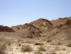
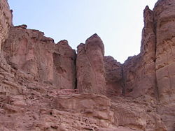
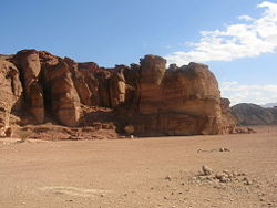
[[Image:Timna 7.JPG|right|thumb|250px|View in [[Timna Park]], Negev, Israel.]] | [[Image:Timna 7.JPG|right|thumb|250px|View in [[Timna Park]], Negev, Israel.]] | ||
| − | The | + | The Negev desert is located in modern day Israel, expanding for over 4600 square miles in the small country. The broad expanse of desert is a vitally important part of the Israeli landscape, stretching over approximately 60 % of the country's landmass. It also plays a role in the religious development of the area, as both the Christian faiths and Judaism assert that the Negev desert was the site where Abraham, Isaac, and Jacob tended their herds. According to the source, the name of the Negev Desert derives from either the Hebrew word for "dry" or "south" . While the origin of the name is contentious, both possible definitions seem plausible. |
==Geography== | ==Geography== | ||
| Line 17: | Line 17: | ||
The Negev can be split into five different ecological regions: Northern, Western and Central Negev, the High Plateau and the Arava Valley. The Northern Negev, or Mediterranean Zone receives 300 mm of rain annually and has fairly fertile soils. The Western Negev receives 250 mm of rain per year, with light and partially sandy soils. Sand dunes can reach heights of up to 30 metres here. Home to the city of [[Beersheba]], the Central Negev has an annual precipitation of 200 mm and is characterized by impervious soil, allowing minimum penetration of water with greater soil erosion and water runoff. The high plateau area of Ramat HaNegev ({{lang-he|רמת הנגב}}, ''The Negev Heights'') stands between 370 metre and 520 metre above sea level with extreme temperatures in summer and winter. The area gets 100 mm of rain per year, with inferior and partially salty soils. The [[Arava Valley]] along the Jordanian border stretches 180 km from Eilat in the south to the tip of the Dead Sea in the north. The Arava Valley is very arid with barely 50 mm of rain annually, the Arava has inferior soils in which little can grow without irrigation and special soil additives. | The Negev can be split into five different ecological regions: Northern, Western and Central Negev, the High Plateau and the Arava Valley. The Northern Negev, or Mediterranean Zone receives 300 mm of rain annually and has fairly fertile soils. The Western Negev receives 250 mm of rain per year, with light and partially sandy soils. Sand dunes can reach heights of up to 30 metres here. Home to the city of [[Beersheba]], the Central Negev has an annual precipitation of 200 mm and is characterized by impervious soil, allowing minimum penetration of water with greater soil erosion and water runoff. The high plateau area of Ramat HaNegev ({{lang-he|רמת הנגב}}, ''The Negev Heights'') stands between 370 metre and 520 metre above sea level with extreme temperatures in summer and winter. The area gets 100 mm of rain per year, with inferior and partially salty soils. The [[Arava Valley]] along the Jordanian border stretches 180 km from Eilat in the south to the tip of the Dead Sea in the north. The Arava Valley is very arid with barely 50 mm of rain annually, the Arava has inferior soils in which little can grow without irrigation and special soil additives. | ||
| − | + | ||
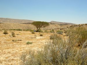
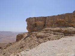
The Negev is a rocky [[desert]]. It is a melange of brown, rocky, dusty mountains interrupted by [[Wadi|wadis]] (dry riverbeds that bloom briefly after rain) and deep craters. The area actually was once the floor of a primordial sea, and a sprinkling of marine snail shells still covers the earth. | The Negev is a rocky [[desert]]. It is a melange of brown, rocky, dusty mountains interrupted by [[Wadi|wadis]] (dry riverbeds that bloom briefly after rain) and deep craters. The area actually was once the floor of a primordial sea, and a sprinkling of marine snail shells still covers the earth. | ||
| − | |||
The whole Negev region is incredibly arid, receiving very little rain due to its location to the East of the [[Sahara]] (as opposed to the [[Mediterranean]] which lies to the West of most of Israel), and extreme temperatures due to its location 31 degrees north. | The whole Negev region is incredibly arid, receiving very little rain due to its location to the East of the [[Sahara]] (as opposed to the [[Mediterranean]] which lies to the West of most of Israel), and extreme temperatures due to its location 31 degrees north. | ||
| Line 55: | Line 54: | ||
Nomadic tribes ruled the Negev largely independently and without interference for the next thousand years.<ref name=Shahinp460/> What is known of this time is largely derived from oral histories and folk tales of tribes from the [[Wadi Musa]] and Petra areas in present-day [[Jordan]]<ref name=Shahinp461>Mariam Shahin. Palestine:A Guide. (2005) Interlink Books. ISBN:156656557</ref> Late in the rule of the [[Ottoman]] empire, an administrative center for southern Palestine was established in Bir es-Saba and schools and a railway station were built.<ref name=Shahinp461/> The authority of the tribal chiefs over the region was recognized by the Ottomans.<ref name=Shahinp461/> | Nomadic tribes ruled the Negev largely independently and without interference for the next thousand years.<ref name=Shahinp460/> What is known of this time is largely derived from oral histories and folk tales of tribes from the [[Wadi Musa]] and Petra areas in present-day [[Jordan]]<ref name=Shahinp461>Mariam Shahin. Palestine:A Guide. (2005) Interlink Books. ISBN:156656557</ref> Late in the rule of the [[Ottoman]] empire, an administrative center for southern Palestine was established in Bir es-Saba and schools and a railway station were built.<ref name=Shahinp461/> The authority of the tribal chiefs over the region was recognized by the Ottomans.<ref name=Shahinp461/> | ||
| − | + | Today | |
Today, the Negev is home to some 379,000 Jews and some 175,000 [[Bedouin]]s. The region's largest city and administrative capital is [[Beersheba]] (pop. around 200,000), in the north. At its southern end is the [[Gulf of Aqaba|Gulf of Eilat]] and the resort [[city]] of [[Eilat]]. Other towns include [[Dimona]], [[Arad, Israel|Arad]], [[Mitzpe Ramon]] as well as a number of small [[Bedouin]] towns, including [[Rahat]] and [[Tel Sheva]]. There are also several ''[[kibbutz]]'' settlements, including [[Revivim]] and [[Sde Boker]]; the latter became the home of Israel's first [[Prime Minister of Israel|Prime Minister]], [[David Ben-Gurion]], after his retirement from politics. | Today, the Negev is home to some 379,000 Jews and some 175,000 [[Bedouin]]s. The region's largest city and administrative capital is [[Beersheba]] (pop. around 200,000), in the north. At its southern end is the [[Gulf of Aqaba|Gulf of Eilat]] and the resort [[city]] of [[Eilat]]. Other towns include [[Dimona]], [[Arad, Israel|Arad]], [[Mitzpe Ramon]] as well as a number of small [[Bedouin]] towns, including [[Rahat]] and [[Tel Sheva]]. There are also several ''[[kibbutz]]'' settlements, including [[Revivim]] and [[Sde Boker]]; the latter became the home of Israel's first [[Prime Minister of Israel|Prime Minister]], [[David Ben-Gurion]], after his retirement from politics. | ||
| Line 61: | Line 60: | ||
The desert is home to the [[Ben-Gurion University]], whose faculties include the [[Jacob Blaustein Institutes for Desert Research]] and the [[Albert Katz International School for Desert Studies]], both located on the [[Midreshet Ben-Gurion]] campus next to [[Sde Boker]]. | The desert is home to the [[Ben-Gurion University]], whose faculties include the [[Jacob Blaustein Institutes for Desert Research]] and the [[Albert Katz International School for Desert Studies]], both located on the [[Midreshet Ben-Gurion]] campus next to [[Sde Boker]]. | ||
| − | == | + | ==People and Culture== |
| − | + | ||
The Negev bedouins are nomadic tribes who have discontinuously inhabited the desert for more than 7,000 years. Although unaffected by external influences throughout history, the tribal culture and way of life has changed dramatically recently.<ref name = Kurt>{{cite journal | The Negev bedouins are nomadic tribes who have discontinuously inhabited the desert for more than 7,000 years. Although unaffected by external influences throughout history, the tribal culture and way of life has changed dramatically recently.<ref name = Kurt>{{cite journal | ||
| author = Kurt Goering | | author = Kurt Goering | ||
| Line 94: | Line 93: | ||
== External links == | == External links == | ||
| − | * [http:// | + | * [http://www.netours.com/jrs/2003/Negev.htm, Tourism in the Negev Desert] Retrieved December 18, 2007. |
| − | + | * [http://www.negev.org/About/negev_desert.htm Israel's Negev Desert] Retrieved December 18, 2007. | |
| − | * [http://www.negev.org/About/negev_desert.htm Israel's Negev Desert] | ||
{{Deserts}} | {{Deserts}} | ||
Revision as of 00:24, 18 December 2007
The Negev desert is located in modern day Israel, expanding for over 4600 square miles in the small country. The broad expanse of desert is a vitally important part of the Israeli landscape, stretching over approximately 60 % of the country's landmass. It also plays a role in the religious development of the area, as both the Christian faiths and Judaism assert that the Negev desert was the site where Abraham, Isaac, and Jacob tended their herds. According to the source, the name of the Negev Desert derives from either the Hebrew word for "dry" or "south" . While the origin of the name is contentious, both possible definitions seem plausible.
Geography
The Negev covers over some 13,000 km² (4,700 sq mi) or 55% of Israel. It forms an inverted triangle shape whose western side is contiguous with the desert of the Sinai Peninsula, and whose eastern border is the Wadi Arabah. The Negev has a number of interesting cultural and geological features. Among the latter are three enormous, craterlike erosion cirques or makhteshim, which are unique to the region: the Ramon Crater, haMakhtesh haGadol ("The Large Makhtesh"), and haMakhtesh haKatan ("The Small Makhtesh").
The Negev can be split into five different ecological regions: Northern, Western and Central Negev, the High Plateau and the Arava Valley. The Northern Negev, or Mediterranean Zone receives 300 mm of rain annually and has fairly fertile soils. The Western Negev receives 250 mm of rain per year, with light and partially sandy soils. Sand dunes can reach heights of up to 30 metres here. Home to the city of Beersheba, the Central Negev has an annual precipitation of 200 mm and is characterized by impervious soil, allowing minimum penetration of water with greater soil erosion and water runoff. The high plateau area of Ramat HaNegev (Hebrew: רמת הנגב, The Negev Heights) stands between 370 metre and 520 metre above sea level with extreme temperatures in summer and winter. The area gets 100 mm of rain per year, with inferior and partially salty soils. The Arava Valley along the Jordanian border stretches 180 km from Eilat in the south to the tip of the Dead Sea in the north. The Arava Valley is very arid with barely 50 mm of rain annually, the Arava has inferior soils in which little can grow without irrigation and special soil additives.
The Negev is a rocky desert. It is a melange of brown, rocky, dusty mountains interrupted by wadis (dry riverbeds that bloom briefly after rain) and deep craters. The area actually was once the floor of a primordial sea, and a sprinkling of marine snail shells still covers the earth.
The whole Negev region is incredibly arid, receiving very little rain due to its location to the East of the Sahara (as opposed to the Mediterranean which lies to the West of most of Israel), and extreme temperatures due to its location 31 degrees north.
The average rainfall totals for the May to October period are 0.[1]
Beer Sheva Average Conditions [2]Temperatures are in degrees Celsius.
History
Nomadic life in the Negev dates back 4000 years and the first urbanized settlements were established by a combination of Canaanite, Amalkite, and Edomite groups circa 2000 B.C.E.[1] Pharaonic Egypt is credited with introducing copper mining and smelting in both the Negev and the Sinai between 1400 and 1300 B.C.E.[1] [2]
In the 9th century B.C.E., development and expansion of mining in both the Negev and Edom (modern Jordan) coincided with the rise of the Assyrian Empire.[3]Bir es-Saba was the region's capital and a center for trade in the 8th century B.C.E.[3] Small settlements of Jews in the areas around the capital and later further afield were existent between 1020 and 928 B.C.E.[3]
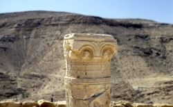
The 4th century B.C.E. arrival of the Nabateans resulted in the development of irrigation systems that supported at least five new urban centers: Oboda, Mamphis, Sobata, Elusa, and Nessana.[3] The Nabateans controlled the trade and spice route between their capital Petra and the Gazan seaports. Nabatean currency, as well as the remains of red and orange potsherds identified as a trademark of their civilization have been found along the route, remnants of which are also still visible.[3]
Nabatean control of southern Palestine ended when the Roman empire annexed their lands in 106 C.E.[3] The population, largely made up of Arabian nomads and Nabateans, remained largely tribal and independent of Roman rule, with an animist belief system.[3]
Byzantine rule in the 4th century AD introduced Christianity to the population.[3] Agricultural-based cities were established and the population grew exponentially.[3]
The arrival of Muslim forces in the 7th century AD was accepted with relative ease by the population, due to their shared Arab background, and Islam was easily adopted by most as well.[3] Upon Islamic conquest, permanent agricultural sites were established and the Ummayads built hundred of farms and systematic terracing of wadis. The efforts, in part were made to settle the semi-nomadic Arab tribes of the area.[4]
Nomadic tribes ruled the Negev largely independently and without interference for the next thousand years.[3] What is known of this time is largely derived from oral histories and folk tales of tribes from the Wadi Musa and Petra areas in present-day Jordan[5] Late in the rule of the Ottoman empire, an administrative center for southern Palestine was established in Bir es-Saba and schools and a railway station were built.[5] The authority of the tribal chiefs over the region was recognized by the Ottomans.[5]
Today
Today, the Negev is home to some 379,000 Jews and some 175,000 Bedouins. The region's largest city and administrative capital is Beersheba (pop. around 200,000), in the north. At its southern end is the Gulf of Eilat and the resort city of Eilat. Other towns include Dimona, Arad, Mitzpe Ramon as well as a number of small Bedouin towns, including Rahat and Tel Sheva. There are also several kibbutz settlements, including Revivim and Sde Boker; the latter became the home of Israel's first Prime Minister, David Ben-Gurion, after his retirement from politics.
The desert is home to the Ben-Gurion University, whose faculties include the Jacob Blaustein Institutes for Desert Research and the Albert Katz International School for Desert Studies, both located on the Midreshet Ben-Gurion campus next to Sde Boker.
People and Culture
The Negev bedouins are nomadic tribes who have discontinuously inhabited the desert for more than 7,000 years. Although unaffected by external influences throughout history, the tribal culture and way of life has changed dramatically recently.[6]
The bedouins of the Negev survive on sheep and goat husbandry. Scarcity of water and of permanent pastoral land requires them to move constantly. The bedouins have established very few permanent settlements.[7]
Notes
- ↑ 1.0 1.1 Mariam Shahin. Palestine: A Guide. (2005) Interlink Books. ISBN:156656557
- ↑ Juan Manuel Tebes. (2007) Centro y periferia en el mundo antiguo. El Negev y sus interacciones con Egipto, Asiria, y el Levante en la Edad del Hierro (1200-586 a.C.) CEHAO Monograph Series Vol. 1 Free access
- ↑ 3.00 3.01 3.02 3.03 3.04 3.05 3.06 3.07 3.08 3.09 3.10 Mariam Shahin. Palestine:A Guide. (2005) Interlink Books. ISBN:156656557
- ↑ Robert Schick (6 1998). Archaeological Sources for the History of Palestine: Palestine in the Early Islamic Period: Luxuriant Legacy. Near Eastern Archaeology 61 (2): 74-1008.
- ↑ 5.0 5.1 5.2 Mariam Shahin. Palestine:A Guide. (2005) Interlink Books. ISBN:156656557
- ↑ Kurt Goering (Autumn, 1979). Israel and the Bedouin of the Negev. Journal of Palestine Studies 9 (1): 3-20.
- ↑ Israel Finkelstein; Avi Perevolotsky (Aug., 1990). Processes of Sedentarization and Nomadization in the History of Sinai and the Negev. Bulletin of the American Schools of Oriental Research (279): 67-88.
Resources
- Evenari, Michael, Leslie Shanan, and Naphtali Tadmor. 1971. The Negev; the challenge of a desert. Cambridge: Harvard University Press. ISBN 9780674606708
- Negev, Avraham. 1977. Archaeology in the land of the Bible. New York: Schocken Books. ISBN 9780805236590
- Meir, Avinoam. 1996. As nomadism ends the Israeli bedouin of the Negev. Boulder, Colo: Westview Press. ISBN 9780813389592
External links
- Tourism in the Negev Desert Retrieved December 18, 2007.
- Israel's Negev Desert Retrieved December 18, 2007.
| Deserts |
|---|
| Ad-Dahna | Alvord | Arabian | Aral Karakum | Atacama | Baja California | Barsuki | Betpak-Dala | Chalbi | Chihuahuan | Dasht-e Kavir | Dasht-e Lut | Dasht-e Margoh | Dasht-e Naomid | Gibson | Gobi | Great Basin | Great Sandy Desert | Great Victoria Desert | Kalahari | Karakum | Kyzylkum | Little Sandy Desert | Mojave | Namib | Nefud | Negev | Nubian | Ordos | Owyhee | Qaidam | Registan | Rub' al Khali | Ryn-Peski | Sahara | Saryesik-Atyrau | Sechura | Simpson | Sonoran | Strzelecki | Syrian | Taklamakan | Tanami | Thar | Tihamah | Ustyurt |
Credits
New World Encyclopedia writers and editors rewrote and completed the Wikipedia article in accordance with New World Encyclopedia standards. This article abides by terms of the Creative Commons CC-by-sa 3.0 License (CC-by-sa), which may be used and disseminated with proper attribution. Credit is due under the terms of this license that can reference both the New World Encyclopedia contributors and the selfless volunteer contributors of the Wikimedia Foundation. To cite this article click here for a list of acceptable citing formats.The history of earlier contributions by wikipedians is accessible to researchers here:
The history of this article since it was imported to New World Encyclopedia:
Note: Some restrictions may apply to use of individual images which are separately licensed.

