Difference between revisions of "Nazca Lines" - New World Encyclopedia
Nick Perez (talk | contribs) |
Nick Perez (talk | contribs) |
||
| Line 54: | Line 54: | ||
==Gallery== | ==Gallery== | ||
| − | < | + | <gallery widths="180px" perrow="3> |
Image:Nasca Monkey 2007 08.JPG| Nasca Monkey | Image:Nasca Monkey 2007 08.JPG| Nasca Monkey | ||
Image:Nazca Lines from 3m in height.JPG| Nazca Lines from 3m in height | Image:Nazca Lines from 3m in height.JPG| Nazca Lines from 3m in height | ||
Revision as of 01:20, 2 January 2009
| Lines and Geoglyphs of Nazca and Pampas de Jumana* | |
|---|---|
| UNESCO World Heritage Site | |

| |
| State Party | |
| Type | Cultural |
| Criteria | i, iii, iv |
| Reference | 700 |
| Region** | Latin America and the Caribbean |
| Inscription history | |
| Inscription | 1994 (18th Session) |
| * Name as inscribed on World Heritage List. ** Region as classified by UNESCO. | |
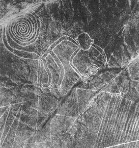
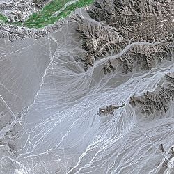
The Nazca lines are a series of geoglyphs located in the Nazca Desert, a high arid plateau that stretches more than 80 km (50 miles) between the towns of Nazca and Palpa on the Pampas de Jumana in Peru. They are believed to have been created by the Nazca culture between 200 B.C.E. and 700 C.E. There are hundreds of individual figures, ranging in complexity from simple lines to stylized hummingbirds, spiders, monkeys, fish, sharks, llamas and lizards. Despite having been studied for many years, archaeologists still do not have a consensus for the purpose of the forms. Hence, the Nazca Lines remain one of the many mysteries of the ancient world. In 1994, The plain of Nazca Lines was deemed a UNESCO Heritage Site, in order to protect the ancient creations from modern human encroachment.
Overview
The Naszca culture flourished from the first to eighth centuries AD beside the dry southern coast of Peru in the river valleys of the Rio Grande de Nazca drainage and the Ica Valley[1] Early Nasca society was made up of local chiefdoms and regional centers of power centered around Cahuachi, a non-urban ceremonial site of mounds and plazas.[2]. Having been heavily influenced by the preceding Paracas culture, which was known for extremely complex textiles, the Nasca produced an array of beautiful crafts and technologies such as ceramics, textiles, along with the famous Nazca lines. Nazca subsistence was based largely on agriculture. Iconography on ceramics and excavated remains indicate that the Nazca people had a varied diet composed of maize, squash, sweet potato, manioc and achira, and even a small trace of various fish. They also utilized several non-food crops such as cotton for textiles, coca, San Pedro cactus, and gourds which were also used to illustrate activities in daily life. In terms of animals resources, the Nasca used the llama and guinea pig for sacrifice at Cahuachi. Llamas were also commonly exploited as pack animals, for their wool, and as a source of meat[3].
No doubt due to the extreme nature of the surrounding environment, much of Nasca religious beliefs centered around agriculture and fertility. Much of Nasca art depicts powerful nature gods such as the mythical killer whale, the harvesters, the mythical spotted cat, the serpentine creature, and the most prevalent of worshiped figures, the anthropomorphic mythical being. Much like the contemporary Moche culture, Shamans apparently used hallucinogenic drugs, such as extractions from the San Pedro cactus, to induce visions.[4]. Religious events and ceremonies took place at the center of Nasca society, in Cahuachi. These ceremonies took place to worship the nature gods to aid in the growth of agriculture and water. During this time, all members of the society in surrounding villages would migrate to the center and participate in feasting as well. Non-elites could obtain highly valued goods such as fancy polychrome pottery through feasting. In exchange, the elites could enhance their political power and status while opting the commoners into labor and construction of the site[5]
Discovery and Investigation
The Nazca lines did not garner the attention of modern society until the early twentieth century, when airplanes began flying over the region.[6]
Construction
The leading explanation for the method of construction employed by the Nazca people involves the use of simple tools and surveying equipment. Wooden stakes in the ground at the end of some lines (which were used to carbon-date the figures) and ceramics found on the surface support this theory. The lines were made by removing the reddish-brown iron oxide coated pebbles which cover the surface of the Nazca desert. When the gravel is removed, the lines contrast sharply with the light-colored earth beneath. There are several hundred simple lines and geometric patterns on the Nazca plateau, as well as over seventy curvilinear animal and human figures.
The area encompassing the lines is nearly 500 square kilometers (193 square miles), and the largest figures can be nearly 270 m long (886 feet). The lines persist due to the extremely dry, windless, and constant climate of the Nazca region. The Nazca desert is one of the driest on Earth and maintains a temperature around 77°F (25°C) all year round, and the lack of wind has helped keep the lines uncovered to the present day.[7]
Theories
The exact reason the figures were built remains a mystery. A leading theory is that the Nazca people's motivations were religious, and that the images were constructed so that gods in the sky could see them. Kosok and Reiche advanced one of the earliest reasons given for the Nazca Lines: that they were intended to point to the places on the distant horizon where the Sun and other celestial bodies rose or set. This hypothesis was evaluated by two different experts in archaeoastronomy, Gerald Hawkins and Anthony Aveni, and they both concluded that there was insufficient evidence to support an astronomical explanation.
In 1985, the archaeologist Johan Reinhard published archaeological, ethnographic, and historical data demonstrating that worship of mountains and other water sources played a dominant role in Nazca religion and economy from ancient to recent times. He presented the theory that the lines and figures can be explained as part of religious practices involving the worship of deities associated with the availability of water and thus the fertility of crops. The lines were interpreted as being primarily used as sacred paths leading to places where these deities could be worshiped and the figures as symbolically representing animals and objects meant to invoke their aid. However, the precise meanings of many of the individual geoglyphs remain unsolved.
Another theory contends that the lines are the remains of "walking temples," where a large group of worshipers walked along a preset pattern dedicated to a particular holy entity, similar to the practice of labyrinth walking. Residents of the local villages say the ancient Nazca conducted rituals on these giant drawings to thank the gods and to ensure that water would continue to flow from the Andes.[citation needed] This view correlates with the purposes of North American geoglyphs.[citation needed]
Notwithstanding Gerald Hawkins' and Anthony Aveni's dismissal of an astronomical explanation of the Nazca Lines and geoglyphs, astronomer Robin Edgar has theorized that the Nazca Lines, particularly the biomorph geoglyphs that depict animals, human figures, birds and "flowers" are an ancient response to what he called the"Eye of God" that is manifested in the sky during a total solar eclipse. According to Edgar, an unusual series of total solar eclipses over southern Peru coincided with the time period during which the Nazca Lines and geoglyphs were created.[citation needed]
Some, such as Jim Woodmann, have proposed that the Nazca lines presuppose some form of manned flight, in order to properly see the figures, and that a hot air balloon was the only possible available technology. Woodmann actually made a hot air balloon from materials and using techniques that he believed would have been available to people at the time to test this hypothesis. The balloon flew, after a fashion, but there is no evidence in support of Nazca-era hot air balloons [8] and Woodman's work has been rebutted.[9]
Gallery
- Nasca Monkey 2007 08.JPG
Nasca Monkey
- Nazca Lines from 3m in height.JPG
Nazca Lines from 3m in height
- Nazca Lines from Mirador.JPG
Nazca Lines from Mirador
Notes
- ↑ Silverman Helaine and Donald Proulx. The Nasca" (Wiley-Blackwell , 2002. ISBN 0631232249)
- ↑ Cahuachi: New Evidence for an Early Nasca Ceremonial Role. By Lidio M. Valdez, Current Anthropology 35, no. 5 (December 1994): 675-679
- ↑ Silverman Helaine and Donald Proulx. The Nasca" (Wiley-Blackwell , 2002. ISBN 0631232249)
- ↑ Silverman Helaine and Donald Proulx. The Nasca" (Wiley-Blackwell , 2002. ISBN 0631232249)
- ↑ Cahuachi: Non-Urban Cultural Complexity on the South Coast of Peru. By Helaine Silverman, Journal of Field Archaeology (1988), Volume 15, No. 4:403-430
- ↑ (2008) Peru Travel Diary: Machupicchu-inca.com "Nazca Lines Mysteries : Can anybody solvethem ? Ever ?" Retrieved January 1, 2009
- ↑ Nazca Lines. (2009). In Encyclopædia Britannica. Retrieved January 1, 2009, from Encyclopædia Britannica Online: http://www.search.eb.com/eb/article-9055110
- ↑ Haughton (2007)
- ↑ http://www.hallofmaat.com/modules.php?name=Articles&file=article&sid=96 Grounding the Nasca Balloon by Katherine Reece
ReferencesISBN links support NWE through referral fees
- Aveni, Anthony F. (ed.) (1990). The Lines of Nazca. Philadelphia: American Philosophical Society. ISBN 0-87169-183-3
- Aveni, Anthony F. (2000). Between the Lines: The Mystery of the Giant Ground Drawings of Ancient Nasca, Peru . Austin Texas: University of Texas Press. ISBN 0-292-70496-8
- Haughton, Brian. (2007). Hidden History: Lost Civilizations, Secret Knowledge, and Ancient Mysteries. Career Press. ISBN 1564148971
- Lambers, Karsten (2006). The Geoglyphs of Palpa, Peru: Documentation, Analysis, and Interpretation. Lindensoft Verlag, Aichwald/Germany. ISBN 3-929290-32-4
- Reinhard, Johan (1996) (6th ed.) The Nazca Lines: A New Perspective on their Origin and Meaning. Lima: Los Pinos. ISBN 84-89291-17-9
External links
- Nazca lines at the Open Directory Project
- Palpa, Peru Google map
- Palpa, Peru Google map
- The Nazca Lines from Satellite and Videos
- Nazca Lines and Culture
- The Nasca Lines Project (1996-2000)
- Nazca Lines
Credits
New World Encyclopedia writers and editors rewrote and completed the Wikipedia article in accordance with New World Encyclopedia standards. This article abides by terms of the Creative Commons CC-by-sa 3.0 License (CC-by-sa), which may be used and disseminated with proper attribution. Credit is due under the terms of this license that can reference both the New World Encyclopedia contributors and the selfless volunteer contributors of the Wikimedia Foundation. To cite this article click here for a list of acceptable citing formats.The history of earlier contributions by wikipedians is accessible to researchers here:
The history of this article since it was imported to New World Encyclopedia:
Note: Some restrictions may apply to use of individual images which are separately licensed.

