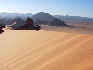
Libyan Desert
The Libyan Desert (24 degrees North, 25 degrees East) (Arabic: الصحراء الليبية), or Great Sand Sea, or Western Desert, is an African desert that is located in the northern and eastern part of the Sahara Desert and occupies southwestern Egypt, eastern Libya and northwestern Sudan. Covering an area of approximately 1,100,000 square kilometers it extends approximately 1,100 km from east to west, and 1,000 km from north to south, in about the shape of a rectangle.
This desert is primarily sand and boulder plain and is inhabited by the Senussis. The dominant wildlife are sand vipers and scorpions.
Ridges and deep depressions (basins) exist in several parts of the desert, and no rivers or streams drain into or out of the area. The desert's Jilf al Kabir Plateau has an altitude of about 2,000 meters, an exception to the uninterrupted territory of basement rocks covered by layers of horizontally bedded sediments, forming a massive plain or low plateau.
There are eight important depressions in the Libyan Desert, and all are considered oases except the smallest, Qattara, because its waters are salty. Limited agricultural production, the presence of some natural resources, and permanent settlements are found in the other seven depressions, all of which have fresh water provided by the Nile or by local groundwater.
The Siwa Oasis, close to the Libyan border and west of Qattara, is isolated from the rest of Egypt but has sustained life since ancient times.
The other major oases include Dakhla and Kharga in Egypt, and Jaghbub in Libya, which, along with Siwah, form a topographic chain of basins extending from the Al Fayyum Oasis (sometimes called the Fayyum Depression) which lies sixty kilometers southwest of Cairo, south to the Bahariya, Farafra and Dakhla oases before reaching the country's largest oasis, Kharga Oasis. A brackish lake, Lake Karun, at the northern reaches of Al Fayyum Oasis, drained into the Nile in ancient times. For centuries sweetwater artesian wells in the Fayyum Oasis have permitted extensive cultivation in an irrigated area that extends over 2,100 square kilometers.
Key geographic feaures of the Libyan Desert
The Qattara Depression
The Qattara Depression, which contains the second lowest point in Africa, is approximately 15,000 km². (about the size of Connecticut and Rhode Island), and is largely below sea level (its lowest point is 133 meters below sea level). The sparsely inhabited Qattara Depression is covered by badlands, salt marshes and salt lakes.
The Gilf Kebir
The Gilf Kebir plateau rises about 300 metres (1,000 ft) above the general plain, and lies entirely in Egypt. It roughly equals Switzerland in size, and is similar in structure to the other sandstone plateaus of the central Sahara. Its south-eastern part is well defined on all sides, with sheer cliffs and deep, narrows wadis. The northeast part, separated from the other half by a broad valley called the "Gap" is more broken, and supports three large wadis with vegetation.
The Sand Seas
The three sand seas, which contain dunes up to 110 meters in height and which cover approximately one quarter of the region include:
- Egyptian Sand Sea
- Kalansho Sand Sea
- Ribiana Sand Sea
Modern Exploration
Sahara was traversed by mostly Muslims traders and natives to the Sahara with pilgrims. It has received lots of writings from the likes of Ibn Battuta.
The first modern explorer to the Sahara was the German Friedrich Gerhard Rohlfs. In his daring expeditions on 1865 in which he's received much resistance from the natives of the Saharan oases and kingdoms he's visited. Because of the much resistance to all European explorers at the time specially by Senussis Ikhwan, Rohlfs managed to come back with several important findings and a first map of the Libyan Desert. Unfortunately it contained inaccuracies in the mapping and intentions of the natives.
It was not before the 1924, when Ahmed Hassanein has ventured into a 3500km expedition on foot in which he single-handedly set the first accurate maps and discovered the legendary oasis of Jebel Uweinat. He wrote important accounts on the Senussis explaining their lifestyle and ethics to the civilised world in his important book The Lost Oases.
Notes
ReferencesISBN links support NWE through referral fees
External links
- The complete text and photos of the discoveries of Ahmed Pasha Hassanein in the Libyan Desert, National Geographic Magazine article, September 1924
- Travel-To-Egypt Page concerning the Libyan Desert
Credits
New World Encyclopedia writers and editors rewrote and completed the Wikipedia article in accordance with New World Encyclopedia standards. This article abides by terms of the Creative Commons CC-by-sa 3.0 License (CC-by-sa), which may be used and disseminated with proper attribution. Credit is due under the terms of this license that can reference both the New World Encyclopedia contributors and the selfless volunteer contributors of the Wikimedia Foundation. To cite this article click here for a list of acceptable citing formats.The history of earlier contributions by wikipedians is accessible to researchers here:
The history of this article since it was imported to New World Encyclopedia:
Note: Some restrictions may apply to use of individual images which are separately licensed.
