Difference between revisions of "Kumgangsan" - New World Encyclopedia
(Applied Category tags, checked spelling, applied Ready tag.) |
Anne Inoue (talk | contribs) (Category:Korea) |
||
| Line 135: | Line 135: | ||
{{Credits|147957858}} | {{Credits|147957858}} | ||
| + | [[Category:Korea]] | ||
Revision as of 16:48, 19 November 2007
| KŭGeumgangsan ("Diamond Mountain") | |
|---|---|
| Korean Name | |
| McCune-Reischauer | Kŭmgangsan |
| Revised Romanization | Geumgangsan |
| Hangul | 금강산 |
| Hanja | 金剛山 |
| Statistics | |
| Height | 1638 meters |
| Location | Kŭmgangsan Tourist Region, North Korea |

| |
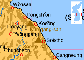
Kŭmgangsan ("Diamond Mountain") is one of the most well-known mountains in North Korea, with a height of 1638 meters. It is located on the east coast of the country, in Kŭmgangsan Tourist Region, formerly part of Kangwŏn Province (38.58N, 128.17E). Kŭmgangsan is part of the Taebaek mountain range which runs along the east of the Korean peninsula.
Kŭmgangsan has been known for its beauty since antiquity. It is covered in forests, and the area around Geumgangsan has some of the highest levels of precipitation in Korea. The mountain not only features a landscape formed by erosion, but also a great number of deep ponds and waterfalls.
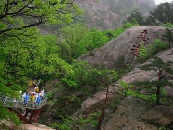
The mountain consists almost entirely of Granite and diorite, which have been weathered over centuries to create a wide variety of shapes. There are a great number of picturesque stone formations, ravines, cliffs, stone pillars and peaks. Over 12,000 such stone formations have been counted. According to the North Korean Government's promotional video, nobody knows who counted them, or when.
Kŭmgangsan is commonly divided into three areas: Inner KŭGEumgang, Outer Kŭmgang, and Sea KŭGEumgang, each with different geological and topographical features. Inner Kŭmgang is noted for its views. The Manpok ravine is popular with tourists. Outer Kŭmgang is noted for the large number of peaks. Jipson Peak (rock of ten thousand forms) is known for its many waterfalls. The Sea Kŭmgang area is known for the lagoons and stone pillars.
There are many old temples around Kŭmgangsan, although not all are preserved in good condition. Probably the best known temples are Jangan-sa and Maha-yon. Other features include: Sea Manmulsang, KŭGEumgang Gate, Samil Lagoon, Piro Peak, the Manpok ravine, Myongyong rock, the Baektap ravine, Manmulsang, Kuryong pond, the pools of Upper Pal, Sujong Peak, Ongnyu ravine, the Hanha Stream, and the Sibi waterfalls.
Kŭmgangsan Tourist Region
Since 1998, South Korean tourists have been allowed to visit Kŭmgangsan, initially traveling by cruise ship, but recently more commonly by coach. In 2002, the area around the mountain was separated from Kangwŏn Province and organized as a separately administered Tourist Region. The land route was opened in 2003. A rail link exists on the North Korean side up to the border, but no tracks are laid between Gangneung and the border in South Korea.
In 1998 there were 15,500 tourists in November and December, in 1999 there were 148,000, and in 2000 213,000. In 2001 tourist numbers dropped to 58,000 amidst disagreements over the access over land. By 2002 almost 500,000 have visited the Kŭmgangsan Tourist Region. Tourist numbers have since established themselves at about 240,000 a year. In June 2005 Hyundai Asan announced the 1 millionth South Korean visit to the area.
The Kŭmgangsan Tourist Region is thought to be one way for the North Korean government to receive hard currency from abroad. Therefore the official currency of the tour is neither the South Korean won nor the North Korean won, but the US Dollar. Since 2003 food and services to South Korean tourists are provided by North Koreans. The area is developed by Hyundai Asan, who have plans to expand the site with a proper ski resort to complement the current sleigh course, and complete golf courses. Many plans for expansion, however, are in their earliest stages.
paste from wiki tourist site
Kumgangsan (금강산 Geumgangsan), literally the Diamond Mountains, is in North Korea.
Understand
Kumgangsan is the second-tallest mountain in North Korea, its highest peak Pirobong is 1638 meters. The area is famed for its scenic beauty, and 1998 became the first and only part of North Korea that can be visited on organized tours from the South. The millionth visitor arrived in July 2005.
Get in
From South Korea
Mt. Kumgang [1], tel. +82-2-739-1090, organizes tours from South Korea to Kumgangsan. Hyundai Asan [2], tel. +82-2-3669-3000, is the company behind the tours and has some information in English.
GOnSEEMt. Kumgang North Korea Tour. GoNSeeKorea.com. Retrieved November 9, 2007.</ref> is the official agent for foreign tourist to Kumgangsan tour. This company provides 4 types tour packages. And if your group is more than 4 people, you can travel with English speaking tour guide.
There are two main ways to visit: either by bus from Goseong, in which case it's even possible to daytrip, or by cruise ship from Sokcho, in which case the tour takes a minimum of three days. Prices start at around W400,000 but vary greatly depending on day of departure, the hotel you stay in, etc. Non-Korean visitors are rare but welcome, although the tours are not set up for visitors with no Korean ability. Reservations should be made 7 days in advance.
English Tours to Kumgansan are available, as well. Prices vary between 610 and 660US$ ( as of October 2006 ) for a 2 nights / 3 days (Friday 9 am until Sunday about 6:30pm) trip from Seoul. Cheaper tours may be available. Check with English-speaking tour company Adventure Korea.
Laptops, PDAs, cell phones, cameras with 160mm or longer lenses, binoculars with 10x zoom or higher are not allowed. Video cameras may be confiscated at the border - unless the zoom is less than 24x. Anything taken will be stored, and returned to you upon exit from North Korea.
Foreigners do not seem to need a re-entry permit if leaving from South Korea to the North. Before going through customs you will receive a temporary passport (a small booklet with passport information written on it, a debit card to be used in tourist zones, a filled embarkment card. These will be in a plastic sheath, to be worn around the neck at all times while in the North.
South Korean exit procedures are performed at the Goseong Observatory. There is a special line for Foreigners, (aptly, although somewhat bluntly, labeled "Foreigner"). You will receive a South Korean exit stamp. On the other side, you will be assigned a bus, that you will stay with for the duration of the tour. Remember your bus number, or you will most likely face hassle from North Korean border guards.
Get around
Independent travel is not allowed. You will be bused around with your tour group at all times.
See
The Diamond Mountains are considered the most dramatic scenery in all of North Korea. It includes waterfalls, lagoons, mineral springs and Buddhist temples and hermitages. Park officials provide maps that help you choose between the many attractive sites. The area is divided into Inner, Outer and Sea Kumgangsan.
Inner Kumgangsan
- Pyohon Temple, established in the year 670. One of the most important Zen monasteries in Korea. Once the temple contains several treasures and valuable cultural assets, however these were either lost or taken to Japan during the times of Japanese colonial rule.
Outer Kumgangsan
- Kuryong Falls. 4 meters wide and with a drop of 74 meters, the falls are an impressive experience. There is a platform, the Kuryong Pavilion, offering a good view. The pond below is called Kuryong Lake. According to the myth, once upon a time nine dragons were there to defend the Kumgang Mountain. From the lake you can walk down a bit, cross Ryondam Bridge and then climb for 700 meters to Kuryong Rock. Here you will have a spectacular view of a deep valley and several lakes.
- Manmulsang Area. Fantastically shaped cliffs and rocks, about a 10-kilometer drive from the Kumgangsan Hotel. Among the peculiarly shaped rocks are Samson (three-fairy) rock, consisting of three rocks standing side by side behind Mansang pavilion at the entrance to Manmulsang. There's also the Kwimyon (demonfaced) rock, made up by a small rock standing on a bigger one, and the Chonson (fairies-from-heaven) rock which serves as an observatory. Ten people can stand here and look out at the peaks. According to the myth fairies came here to play. Northwest of the rock, is the Fairies Lake, where the fairies washed themselves before returning to heaven.
Sea Kumgangsan
- Samil Lagoon. According to legend, a king once visited the lake for a day but was so amazed by its beauty that he stayed there for three days, hence the name Samil (three days). You can rent a boat and make a trip on the lake. By the lake is Tanpung Restaurant, where you can rest and have a meal afterwards.
Do
Buy
There are many stores and shops selling a wide range of goods from international duty free items to North Korean products which allow the visitors to bring home a little bit of North Korea back South. Jewelry and liquor and cosmetics are sold at high quality standards. Also, there is a shop selling health care supplements and functional cosmetics which do quite well. They carry a variety of vitamins as well as other outstanding health foods designed to enhance your well-being. Souvenirs are also available and they are quite popular as well. Finally, it seems there are an array of small item stores which allow you to spend your money wisely.
Eat
Drink
Sleep
Kumgangsan Hotel, Onjong-ri, Kosong. A 1st-class hotel, opened in 1958. There are 240 rooms and a few bungalows. Facilities are a shop, dance room, bar and a bathhouse that derives hot water from a spring.
Get out
End paste from Wiki Tourist
See also
- List of Korea-related topics
- List of mountains in Korea
- Geography of North Korea
Notes
- ↑ Mt. Kumgang Tour. MtKumgang.com. Retrieved November 9, 2007.
- ↑ Mt. Kumgang. Hyundai Asan. Retrieved November 9, 2007.
External links
- Travel guide to Kumgangsan from Wikitravel
Credits
New World Encyclopedia writers and editors rewrote and completed the Wikipedia article in accordance with New World Encyclopedia standards. This article abides by terms of the Creative Commons CC-by-sa 3.0 License (CC-by-sa), which may be used and disseminated with proper attribution. Credit is due under the terms of this license that can reference both the New World Encyclopedia contributors and the selfless volunteer contributors of the Wikimedia Foundation. To cite this article click here for a list of acceptable citing formats.The history of earlier contributions by wikipedians is accessible to researchers here:
The history of this article since it was imported to New World Encyclopedia:
Note: Some restrictions may apply to use of individual images which are separately licensed.


