Conakry
| Conakry Kɔnakiri |
|
| Conakry, Guinea | |
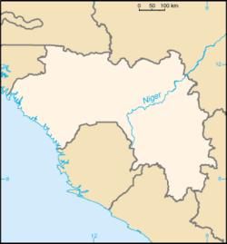
| Map of Guinea showing the location of Conakry. | |
| Coordinates: 9°31′N 13°42′W | |
|---|---|
| Region | Conakry Region |
| Population (2008) | |
| - Total | 1,857,153 |
| Time zone | CET (UTC+1) |
| - Summer (DST) | CEST (UTC+1) |
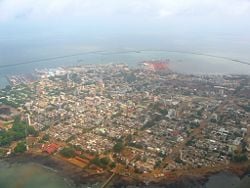
Conakry or Konakry (Malinké: Kɔnakiri) is the capital and largest city of Guinea. Population 1,857,153 (2008 est). [1]
Guinea's capital city is a port on the Atlantic Ocean. Originally situated on Tombo Island, one of the Îles de Los, it has since spread up the neighboring Kaloum Peninsula. The population of Conakry is difficult to ascertain, although the U.S. Bureau of African Affairs has estimated it at 2 million.[2] Even given this uncertainty, Conakry makes up almost a quarter of the population of Guinea.
Geography
According to a legend, the name of the city comes from the fusion of the name "Cona", a wine and cheese producer of the Baga people, and the word "nakiri", which means the other bank or side.[3] Topography: Physical qualities of a particular place. Example: Mexico City a. Mountain flanked basin b. on dry lake bed c. vulnerability to earthquakes d. trapped air pollution (also true in L.A. and Athens) Elevation Climate (not required unless it makes the city a resort) The city (Johannesburg) enjoys a dry, sunny climate, with the exception of occasional late afternoon downpours in the summer months of October to April. Temperatures are usually fairly mild due to the city's high altitude, with the average maximum daytime temperature in January of 79°F (26°C), dropping to an average maximum of around 61°F (16°C) in June. Winter is the sunniest time of the year, with cool days and cold nights. The temperature occasionally drops to below freezing at night, causing frost. Snow is rare. Mean annual precipitation is 28 inches (716mm). Rivers and canals Size – land area, size comparison Environmental issues Districts Today, the city has grown along the peninsula to form five main districts. From the tip in the south west, these are Kaloum (the city centre), Dixinn (including the University of Conakry and many embassies), Ratoma (known for its nightlife), Matam and finally Matoto, home to Gbessia Airport.
History
Conakry was originally settled on tiny Tombo Island and later spread to the neighboring Kaloum Peninsula, a 36-kilometer (22 mi) long stretch of land 0.2 to 6 kilometers (0.12 to 3.7 mi) wide. The city was essentially founded after Britain ceded the island to France in 1887. In 1885, the two island villages of Conakry and Boubinet had fewer than 500 inhabitants. Conakry became the capital of French Guinea in 1904 and prospered as an export port, particularly after a (now closed) railway to Kankan opened the large scale export of groundnut from the interior. In the decades after independence, the population of Conakry exploded, from 50,000 inhabitants in 1958 to 600,000 in 1980, to over two million today.[4] Its small size and relative isolation from the mainland, while an advantage to its colonial founders, has created an infrastructural burden since independence.[5]
In 1970, conflict between Portuguese forces and the PAIGC in neighboring Portuguese Guinea (now Guinea-Bissau) spilled into the Republic of Guinea when a group of 350 Portuguese troops and Guinean dissidents landed near Conakry, attacked the city, and freed 26 Portuguese prisoners of war held by the PAIGC before retreating, failing to overthrow the government or kill the PAIGC leadership. [6]
Government
Guinea is a republic in which the president, who is chief of state, is elected by popular vote for a seven-year term and has no limits to the number of terms he may serve. The the prime minister, whis head of government, is appointed by the president. The unicameral People's National Assembly consists of 114 members elected by a mixed system of direct popular vote and proportional party lists.
The city itself makes up one of the eight Regions of Guinea, the Conakry Region, includes 5 of the nation's 38 urban communes, and at the prefect level is designated the Conakry Special Zone.
Economy
Guinea possesses major mineral, hydropower, and agricultural resources, yet remains an underdeveloped nation. The country has almost half of the world's bauxite reserves and is the second-largest bauxite producer. The mining sector accounts for over 70 percent of exports.
Conakry is Guinea's largest city and its administrative, communications, and economic center. The city's economy revolves largely around the port, which has modern facilities for handling and storing cargo, through which alumina and bananas are shipped.
Guinea's per capita GDP was estimated at $1100 in 2007. An average Guinean in Conakry will get a monthly wage of about $45.
Financial and business services sector Tourism Manufacturing Transport: Road, rail, air, sea
Manufactures include food products and Housing Materials.
Infrastructural crisis
Periodic power and water cuts are a daily burden for Conakry's residents, dating back to early 2002. Government and power company officials blame the drought of 2001-2 for a failure of the hydro-electric supply to the capital, and a failure of aging machinery for the continuation of the crisis. Critics of the government cite mis-management, corruption, and the pull out of the power agency's French partner at the beginning of 2002. As of 2007, much of the city has no traffic lighting in the overnight hours.[7] Popular anger at shortages in Conakry were entwined with anti-government protests, strikes, and violence over the rule of President Lansana Conté and the successive prime ministers, Cellou Dalein Diallo and Eugène Camara, appointed to fill the post after the resignation of PM François Lounseny Fall in April 2004. Violence reached a peak in January-February 2007 in a general strike, which saw over a hundred deaths when the Army confronted protesters[8]
Demographics
Population, population rank Race/ethnicity - historical background of ethnic groups Language Religion Colleges and universities At two million inhabitants, it is far and away the largest city in Guinea, making up almost a quarter of the nation's population and making it more than four times bigger than its nearest rival, Kankan.
Of interest
Attractions in the city include the Guinea National Museum, several markets, the Guinea Palais du Peuple, Conakry Grand Mosque which was built by Sekou Toure, the city's nightlife and the nearby Iles de Los.
The city is noted for its botanical garden. The Polytechnical Institute of Conakry is also located in Conakry.
The street numbering scheme of Conakry labels all roads with a two-letter code for the urban district, followed by a three digit number: odd for north-south streets and even for east-west, e.g. KA002 for a northbound street in the Kaloum district.
Looking to the future
Long-run improvements in government fiscal arrangements, literacy, and the legal framework are needed if the country is to move out of poverty. Investor confidence has been sapped by rampant corruption, a lack of electricity and other infrastructure, a lack of skilled workers, and the political uncertainty due to the failing health of President Lansana CONTE.
- 2007 Guinean general strike
ReferencesISBN links support NWE through referral fees
- ↑ World Gazetteer, Retrieved on June 16 2008
- ↑ "Background Note: Guinea". Bureau of African Affairs, U.S. Department of State, January 2007. Accessed February 24, 2007.
- ↑ Histoire de Conakry - (French)
- ↑ Patrick Manning. Francophone Sub-Saharan Africa, 1880-1995, Cambridge (1998)
- ↑ For the urban infrastructure and its history, see [ http://www.worldbank.org/urban/forum2002/docs/diallo-pres.pdf. M. Dian DIALLO. Street Addressing And Basic Services In Conakry, Guinea]. Presented at the Urban Forum/ World Bank - Washington DC - April 2 - 4 2002.
- ↑ "Cloudy Days in Conakry", Time Magazine, 1970-12-07.
- ↑ Conakry's dark streets turning orange. James Copnall, BBC News, Guinea . 23 November 2006.
- ↑ For the relations between the 2007 crisis and infrastructure in Conakry, see:
- Q&A: Guinea emergency, BBC World Service. 13 February 2007.
- Youths Chase Staff From State Electricity Offices, Protesting Power Cuts, Oct 25, 2007 (UN Integrated Regional Information Networks/All Africa Global Media via COMTEX).
- IRIN In-Depth, Guinea: Living on the edge. UN Office for the Coordination of Humanitarian Affairs, January 2005.
- GUINEA: Power cuts stop for football, 26 January 2006 (IRIN)
- Guinea protests over power-cuts, Alhassan Sillah: BBC, Conakry, 31 January, 200
- Conflict history: Guinea. International Crisis Group, updated 11 May 2007.
- Thomas O'Toole, Janice E. Baker. Historical Dictionary Of Guinea. Scarecrow Press (2005). ISBN 0810846349
- Odile Goerg. Chieftainships between Past and Present: From City to Suburb and Back in Colonial Conakry, 1890s-1950s. Africa Today, Summer 2006, Vol. 52, No. 4, Pages 2-27
- FallingRain Map - elevation = 28m
- Conakry the Capital: history of the city at site of expat artist.
- HISTOIRE DE CONAKRY, 1463 to present, by Luc MOGENET, reprinted at guineeconakry.info (no date)
- Kids in Guinea Study Under Airport Lamps, RUKMINI CALLIMACHI The Associated Press, Thursday, July 19, 2007.
- Archdiocese of Conakry: history and structure (at catholic-hierarchy.org)
- Guinea's Telecommunication Infrastructure, United Nations Economic Commission for Africa (UNECA), 1999 figures.
External links
- World Fact Book 2008 Guinea Retrieved September 2, 2008.
- http://www.portautonomedeconakry.com/: official site of the Conakry Port Authority.
- http://www.guineeconakry.info/: Conakry - based news portal
- Office de Promotion des Investissements Privés, République du Guinée.
- Office National du Tourisme, République du Guinée.
- l’Université Kofi Annan de Guinée (UNIKAG)
- Satellite image of Conakry and the Kaloum Peninsula, from the European Space Agency's Envisat: image description at http://www.esa.int/esaEO/SEMAV21XDYD_index_1.html.
Credits
New World Encyclopedia writers and editors rewrote and completed the Wikipedia article in accordance with New World Encyclopedia standards. This article abides by terms of the Creative Commons CC-by-sa 3.0 License (CC-by-sa), which may be used and disseminated with proper attribution. Credit is due under the terms of this license that can reference both the New World Encyclopedia contributors and the selfless volunteer contributors of the Wikimedia Foundation. To cite this article click here for a list of acceptable citing formats.The history of earlier contributions by wikipedians is accessible to researchers here:
The history of this article since it was imported to New World Encyclopedia:
Note: Some restrictions may apply to use of individual images which are separately licensed.


