Difference between revisions of "Tomb of Askia" - New World Encyclopedia
Mary Anglin (talk | contribs) |
Mary Anglin (talk | contribs) |
||
| Line 42: | Line 42: | ||
==Notes== | ==Notes== | ||
<references/> | <references/> | ||
| + | |||
| + | ==References== | ||
| + | * ''African Holocaust''. [http://www.africanholocaust.net/africanlegends.htm#askia Askia The Great (1538)] Retrieved January 26, 2009. | ||
| + | * ''Black History Pages''. [http://www.blackhistorypages.net/pages/askia.php Askia Mohammed I (Askia the Great)] Retrieved January 26, 2009. | ||
| + | * Sliwoski, Amelia Helena. 2007. [http://proquest.umi.com/pqdweb?did=1467887251&sid=6&Fmt=2&clientId=39334&RQT=309&VName=PQD. ''Islamic ideology and ritual architectural and spatial manifestations''.] Thesis (M.A.)—State University of New York at Buffalo, 2007. {{OCLC|232266969}} | ||
| + | * ''The American Forum for Global Education''. 2000. [http://www.globaled.org/nyworld/materials/african3.html Early African Empires and their Global Connections] Retrieved January 26, 2009. | ||
== External links == | == External links == | ||
*[http://whc.unesco.org/en/list/1139 World Heritage Website] | *[http://whc.unesco.org/en/list/1139 World Heritage Website] | ||
*[http://whc.unesco.org/archive/advisory_body_evaluation/1139.pdf UNESCO Evaluation of Askia] (in English and French) | *[http://whc.unesco.org/archive/advisory_body_evaluation/1139.pdf UNESCO Evaluation of Askia] (in English and French) | ||
| − | |||
| − | |||
[[Category:World Heritage Sites]] | [[Category:World Heritage Sites]] | ||
| Line 53: | Line 57: | ||
[[Category:Geography]] | [[Category:Geography]] | ||
{{Credit|262051016}} | {{Credit|262051016}} | ||
| + | {{coord|16|17|23|N|0|02|40|W|region:ML-7_type:landmark|display=title}} | ||
Revision as of 23:49, 26 January 2009
| Tomb of Askia* | |
|---|---|
| UNESCO World Heritage Site | |

| |
| State Party | |
| Type | Cultural |
| Criteria | ii, iii, iv |
| Reference | 1139 |
| Region** | Africa |
| Inscription history | |
| Inscription | 2004 (28th Session) |
| * Name as inscribed on World Heritage List. ** Region as classified by UNESCO. | |
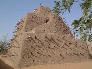
The Tomb of Askia, in Gao, Mali, is believed to be the burial place of Askia Mohammad I, first Emperor of Songhai. A UNESCO World Heritage Site, it was built at the end of the fifteenth century.
UNESCO describes Askia as a fine example of the monumental mud-building traditions of the West African Sahel. The complex includes the pyramidal tomb, two mosques, a cemetery, and an assembly ground. At 17 metres in height it is the largest pre-colonial architectural monument in the region. It is the first example of an Islamic architectural style that later spread throughout the region.
Relatively recent modifications to the site have included the expansion of the mosque buildings in the 1960s and mid-1970s, and the 1999 construction of a wall around the site. It has also been regularly replastered throughout its history, a process essential to the maintenance and repair of mud structures. Electricity was added in the early 2000s, allowing for ceiling fans, lights, and a loudspeaker mounted on top. On the east side is a winding external stair leading to the summit.
Askia is in regular use as a mosque and a publicly owned cultural center for the city of Gao. The site and a buffer area around it are protected by both national and local laws.
History
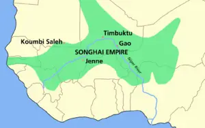
Askia Mohammed was the first Askia emperor and greatly expanded the Songhai Empire, which flourished in the fifteenth and sixteenth centuries through its control of trans-Saharan trade. As a revert Muslim, he felt obligated to make his pilgrimage to Mecca, which he returned from in 1495. He brought back with him the materials to make his tomb; all of the mud and wood come from Mecca. The caravan is said to have consisted of "thousands of camels." It was structured as a house, with several rooms and passageways and was sealed when Mohammed died. Askia Mohommed is the only one buried inside the tomb itself, but several other Askias are buried in the courtyard.
Through much of its history, Gao was a center of trade and learning, and was capital of the Songhai Empire. It is similar to, and culturally connected with the great Trans-Saharan trade cities of Timbuktu and Djenne. The westernmost of the three central routes was the Ghadames Road, which ran from the Niger River at Gao north to Ghat and Ghadames before terminating at Tripoli.
Mediterranean economies were short of gold but could supply salt, whereas West African countries had plenty of gold but needed salt. The trans-Saharan slave trade was also important because large numbers of Africans were sent north, generally to serve as domestic servants or slave concubines.[1] The West African states imported highly trained slave soldiers. It has been estimated that from the 10th to the 19th century some 6,000 to 7,000 slaves were transported north each year.[2] Perhaps as many as nine million slaves were exported along the trans-Saharan caravan route.[3]
The city of Gao was founded around the seventh century as Kawkaw, its first recorded monarch being Kanda, who founded the Za Dynasty of what became the Songhai Empire. He ensured the city’s growth by allowing trans-Saharan traders to visit and Berbers to settle. Trade increased after Za Kossoi converted to Islam in 1009.
The Mali Empire conquered Gao sometime before 1300, but Ali Golon re-established Songhai rule. A distinguished author of the period, Al-Idrissi, described it as a "populous, unwalled, commercial and industrial town, in which were to be found the produce of all arts and trades necessary for its inhabitants".
Mali was a Muslim kingdom, and under it, the gold-salt trade established in earlier times continued. Other, less important trade goods were slaves, kola nuts from the south and slave beads and cowrie shells from the north (for use as currency). It was under Mali that the great cities of the Niger bend —including Gao—prospered.
Under Ali the Great in the late fifteenth century the city became center of an empire, with about 70,000 residents and a 1,000-boat navy, but Gao was largely destroyed by the Moroccan invasion of 1591. The town remained small until French rule was imposed in the early twentieth century, expanding the port and establishing a colonial base.
Notes
- ↑ Ibn Battuta's Trip: Part Twelve - Journey to West Africa (1351 - 1353)
- ↑ Fage, J.D. A History of Africa. Routledge, 4th edition, 2001. pg. 256
- ↑ The impact of the slave trade on Africa
ReferencesISBN links support NWE through referral fees
- African Holocaust. Askia The Great (1538) Retrieved January 26, 2009.
- Black History Pages. Askia Mohammed I (Askia the Great) Retrieved January 26, 2009.
- Sliwoski, Amelia Helena. 2007. Islamic ideology and ritual architectural and spatial manifestations. Thesis (M.A.)—State University of New York at Buffalo, 2007. OCLC 232266969
- The American Forum for Global Education. 2000. Early African Empires and their Global Connections Retrieved January 26, 2009.
External links
- World Heritage Website
- UNESCO Evaluation of Askia (in English and French)
Credits
New World Encyclopedia writers and editors rewrote and completed the Wikipedia article in accordance with New World Encyclopedia standards. This article abides by terms of the Creative Commons CC-by-sa 3.0 License (CC-by-sa), which may be used and disseminated with proper attribution. Credit is due under the terms of this license that can reference both the New World Encyclopedia contributors and the selfless volunteer contributors of the Wikimedia Foundation. To cite this article click here for a list of acceptable citing formats.The history of earlier contributions by wikipedians is accessible to researchers here:
The history of this article since it was imported to New World Encyclopedia:
Note: Some restrictions may apply to use of individual images which are separately licensed.
Coordinates:

