Kyūshū
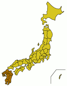
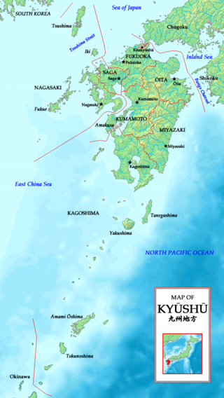
 Kyūshū region of Japan and the current prefectures on the island of Kyūshū | |
| Geography | |
|---|---|
| Location | East Asia |
| Archipelago | Japanese Archipelago |
| Area | 35,640 km² |
| Highest point | Mount Aso (1,591 m) |
| Country | |
| Prefectures | Fukuoka, Kagoshima, Kumamoto, Miyazaki, Nagasaki, Ōita, Saga |
| Largest city | Fukuoka (1,400,000) |
| Demographics | |
| Population | 13,231,995 |
| Density | Sparse people/km2 |
| Ethnic groups | Japanese |
Kyūshū (九州 Nine Provinces)[1] or Kyushu is the third-largest island of Japan and most southwesterly of its four main islands. Its alternate ancient names include Kyūkoku (九国 Nine States), Chinzei (鎮西 West of the Pacified Area), and Tsukushi-no-shima (筑紫島 Island of Tsukushi). The historical regional name Saikaidō (西海道 West Sea Circuit) referred to Kyūshū and its surrounding islands.
Kyūshū has a population of 13,231,995 (2006) and covers 35,640 km².
Geography
The island is mountainous, and Japan's most active volcano, Mt Aso at 1,591 m, is on Kyūshū. There are many other signs of tectonic activity, including numerous areas of hot springs. The most famous of these are in Beppu, on the east shore, and around Mt. Aso, in central Kyūshū.
The name Kyūshū comes from the nine ancient provinces of Saikaidō situated on the island: Chikuzen, Chikugo, Hizen, Higo, Buzen, Bungo, Hyūga, Osumi, and Satsuma.
Today’s Kyūshū Region (九州地方 kyūshū-chihō) is a politically defined region that consists of seven prefectures on Kyūshū and Okinawa Prefecture to the south:
- Fukuoka Prefecture
- Kagoshima Prefecture
- Kumamoto Prefecture
- Miyazaki Prefecture
- Nagasaki Prefecture
- Ōita Prefecture
- Saga Prefecture
The world’s 37th largest island by area, Kyūshū is smaller than Spitsbergen but larger than New Britain and Taiwan. By population, it ranks 13th, having fewer inhabitants than Borneo or Sulawesi, but more than Salsette or Cuba.
By population, the largest city on the island is Fukuoka with its 1.4 million inhabitants; Fukuoka is a major business center with a large international airport as well as one of the five stock exchanges in Japan. Kitakyushu is a designated city and major center for heavy industries, populated by slightly less than a million. Kumamoto and Kagoshima are the island’s third and fourth largest cities with over half a million people each. Nagasaki has one of Japan’s oldest international ports, which was the only gateway to the outside world during the Edo period, from the mid 16th to the mid 18th centuries. Nagasaki is also famous for being hit by one of the atom bombs at the end of WWII.
Economy and climate
Parts of Kyūshū have a subtropical climate, particularly Miyazaki and Kagoshima prefectures. Major agricultural products are rice, tea, tobacco, sweet potatoes, and soy; silk is also widely produced. The island is noted for various types of porcelain, including Arita, Imari, Satsuma, and Karatsu. Heavy industry is concentrated in the north around Kitakyushu, Nagasaki, and Oita and includes chemicals and metal processing.
Education
Major universities and colleges in Kyūshū:
- National universities
- Universities run by local governments
- University of Kitakyushu
- Kyusyu Dental College
- Fukuoka Women's University
- Fukuoka Prefectural University
- Siebold University of Nagasaki
- Nagasaki Prefectural University
- Oita University of Nursing and Health Sciences
- Prefectural University of Kumamoto
- Miyazaki Municipal University
- Miyazaki Prefectural Nursing University
- Okinawa Prefectural University of Arts
- Major private universities
- Fukuoka University - University with the biggest number of students in Kyūshū
- Ritsumeikan Asia Pacific University [3]
- Seinan Gakuin University
- Kyūshū Sangyo University - Baseball Team won the National Championship in 2005
- University of Occupational and Environmental Health
- Kurume University
See also
- Geography of Japan
- List of regions in Japan
Notes and references
- ↑ "Nine Provinces" may also refer to Jiuzhou, a historical division of China
Regions
Hokkaidō ·
Tōhoku ·
Kantō ·
Chūbu
(Hokuriku • Kōshin'etsu • Tōkai • Chūkyō) ·
Kansai ·
Chūgoku ·
Shikoku ·
Kyūshū ·
Ryūkyū
Prefectures
Aichi ·
Akita ·
Aomori ·
Chiba ·
Ehime ·
Fukui ·
Fukuoka ·
Fukushima ·
Gifu ·
Gunma ·
Hiroshima ·
Hokkaidō ·
Hyōgo ·
Ibaraki ·
Ishikawa ·
Iwate ·
Kagawa ·
Kagoshima ·
Kanagawa ·
Kōchi ·
Kumamoto ·
Kyōto ·
Mie ·
Miyagi ·
Miyazaki ·
Nagano ·
Nagasaki ·
Nara ·
Niigata ·
Ōita ·
Okayama ·
Okinawa ·
Ōsaka ·
Saga ·
Saitama ·
Shiga ·
Shimane ·
Shizuoka ·
Tochigi ·
Tokushima ·
Tōkyō ·
Tottori ·
Toyama ·
Wakayama ·
Yamagata ·
Yamaguchi ·
Yamanashi
Designated cities
Special wards of Tokyo ·
Chiba ·
Fukuoka ·
Hamamatsu ·
Hiroshima ·
Kawasaki ·
Kitakyushu ·
Kobe ·
Kyoto ·
Nagoya ·
Niigata ·
Osaka ·
Saitama ·
Sakai ·
Sapporo ·
Sendai ·
Shizuoka ·
Yokohama
Credits
New World Encyclopedia writers and editors rewrote and completed the Wikipedia article in accordance with New World Encyclopedia standards. This article abides by terms of the Creative Commons CC-by-sa 3.0 License (CC-by-sa), which may be used and disseminated with proper attribution. Credit is due under the terms of this license that can reference both the New World Encyclopedia contributors and the selfless volunteer contributors of the Wikimedia Foundation. To cite this article click here for a list of acceptable citing formats.The history of earlier contributions by wikipedians is accessible to researchers here:
The history of this article since it was imported to New World Encyclopedia:
Note: Some restrictions may apply to use of individual images which are separately licensed.
