|
|
| Line 34: |
Line 34: |
| | }} <!-- Infobox ends !--> | | }} <!-- Infobox ends !--> |
| | [[Image:asorock.jpg|right|thumb|Aso Rock]] | | [[Image:asorock.jpg|right|thumb|Aso Rock]] |
| − | '''Abuja''', officially '''Abuja Municipal Area Council''' or AMAC, is the [[capital city]] of [[Nigeria]]. It is located in the centre of Nigeria in the [[Federal Capital Territory, Nigeria| Federal Capital Territory]] (FCT). Abuja is a [[planned city|"planned" city]], as it was mainly built in the 1980s and officially became Nigeria's capital on [[12 December]] [[1991]], replacing the role of the previous capital [[Lagos]]. As of the [[2006]] census, the Federal Capital Territory has a population of 778,567. | + | '''Abuja''', officially '''Abuja Municipal Area Council''', is the [[capital city]] of [[Nigeria]], and is known as the best purpose-built city in Africa as well as one of the wealthiest and most expensive. Abuja is a [[planned city|"planned" city]], as it was mainly built in the 1980s and officially became Nigeria's capital on December 12, 1991, replacing the role of the previous capital [[Lagos]]. As of the [[2006]] census, the Federal Capital Territory has a population of 778,567. |
| | | | |
| − | Abuja's geography is defined by [[Aso Rock]], a 400-metre monolith left by water erosion. The [[Nigerian Presidential Complex|Presidential Complex]], [[Nigerian National Assembly|National Assembly]], [[Nigerian Supreme Court|Supreme Court]] and much of the town extend to the south of the rock. "Aso" means "victorious" in the language of the (now displaced) [[Asokoro]] ("the people of victory"). | + | ===Geography=== |
| | + | [[Image:MosqueinAbuja.jpg|right|thumb|250px| Abuja National Mosque during [[Harmattan]].]] |
| | + | Located approximately 300 miles (480 km) northeast of Lagos, in the centre of Nigeria in the Federal Capital Territory, Abuja lies at 1180 feet (360 meters) above sea level and has a cooler climate and less humidity than is found in Lagos. |
| | + | Abuja's geography is defined by [[Aso Rock]], a 400-metre monolith left by water erosion. "Aso" means "victorious" in the language of the (now displaced) [[Asokoro]] ("the people of victory"). |
| | | | |
| − | Other sights include the [[Nigerian National Mosque]] and the [[Nigerian National Christian Centre]]. The city is served by the [[Nnamdi Azikiwe International Airport]], while [[Zuma Rock]] lies nearby. Abuja is known for being the best purpose-built city in Africa as well as being one of the wealthiest and most expensive; however, the population on the semi-developed edges of the city are living in [[shanty town]]s such as [[Karu]]. Karu, built to house the capital's civil servants and lower income families, has no running water, sanitation or electricity.<ref>[http://news.bbc.co.uk/1/hi/world/africa/6355269.stm BBC NEWS | World | Africa | Life of poverty in Abuja's wealth<!-- Bot generated title —>]</ref>
| + | Abuja undergoes three weather conditions annually. This includes a warm, humid [[rainy season]], from April to October, and a blistering [[dry season]], when daytime temperatures can soar as high as 40 degrees. In between the two seasons, there is a brief interlude of [[harmattan]] occasioned by the North East Trade Wind, with the main feature of dust haze, intensified coldness and dryness. The annual total rainfall is in the range of 1100mm to 1600mm. |
| | | | |
| − | == History ==
| + | Abuja has several parks and green areas with the largest one being Millennium park, which was designed by world renowned architect [[Manfredi Nicoletti]] and was officially opened by Queen [[Elizabeth II of England]]. |
| − | In light of the ethnic and religious divisions of Nigeria, plans had been devised since Nigeria's independence to have its capital in a location deemed neutral to all parties. The location was eventually designated in the centre of the country in the early 1970s as it signified neutrality and national unity. Another impetus for Abuja came because of [[Lagos]]'s population boom, that made that city overcrowded and conditions squalid. The logic used was similar to [[Brazil]] building its capital [[Brasília]].
| |
| | | | |
| − | Construction broke ground and was dedicated in the late 1970s, but due to economic and political instability, the city in its initial stages was not complete until the late 1980s.
| + | Sights include the [[Nigerian National Mosque]] and the [[Nigerian National Christian Centre]]. The city is served by the [[Nnamdi Azikiwe International Airport]], while [[Zuma Rock]] lies nearby. However, the population on the semi-developed edges of the city are living in [[shanty town]]s such as [[Karu]], which was built to house the capital's civil servants and lower income families, and has no running water, sanitation or electricity. |
| | | | |
| − | The master plan for Abuja and the Federal Capital Territory was developed by IPA (International Planning Associates), a consortium made up of three American firms: PRC Corporation; Wallace, McHarg, Roberts and Todd; and, Archisystems, which was a division of the [[Hughes Organization]]. The master plan for Abuja defined the general shape and major design elements of the city, however a refinement of this design was accomplished by [[Kenzo Tange]], a renowned Japanese architect, along with his team of city planners at [[Kenzo Tange and Urtec]] company.
| + | == History == |
| | + | Since Nigeria's independence from the United Kingdom, on October 1, 1960, ethnic and religious divisions required the creation of a capital city in a location deemed neutral to all parties. Also, [[Lagos]]'s population boom made that city overcrowded and conditions squalid. |
| | | | |
| − | Most countries moved their [[embassy|embassies]] to Abuja and maintain their larger former embassies as [[Consul (representative)|consulates]] in the commercial capital, [[Lagos]].
| + | The site for a new capital was chosen because of its central location, easy accessibility, pleasant climate, low population density, and the availability of land for future expansion. |
| | | | |
| − | In addition to a major governmental centre, Abuja is the headquarters of the [[ECOWAS|Economic Community of West African States]] or ECOWAS, as well as its Military arm, [[ECOMOG]]. It also has the regional headquarters of [[OPEC]].
| + | A consortium of three American firms: PRC Corporation; Wallace, McHarg, Roberts and Todd; and, Archisystems, created a master plan for Abuja. Renowned Japanese architect [[Kenzo Tange]] refined the design |
| | | | |
| − | Abuja and the FCT have experienced a huge population growth; it has been reported that some areas around Abuja have been growing at 20 – 30%.<ref name="WBC">{{cite web |url= http://www.citiesalliance.org/cdsdb.nsf/Attachments/South+Africa+roundtable/$File/African+Regional+Roundtable+on+Upgrading+Oct00.pdf|title= World Bank Conference: African Regional Roundtable on Upgrading Low-income Settlements |accessdate=2007-08-10 |work= www.citiesalliance.org |publisher=World Bank, [[October 3]]-5 2000, Johannesburg, South Africa, p. 16 }}</ref> Squatter settlements and shanty towns have spread rapidly in and outside the city limits.<ref name="bbc">{{cite web |url= http://news.bbc.co.uk/2/hi/africa/6355269.stm|title= Life of poverty in Abuja's wealth|accessdate=2007-08-10 |work= news.bbc.co.uk |publisher=BBC News, Tuesday, [[13 February]] [[2007]]}}</ref><ref name="fig">{{cite web |url= http://www.fig.net/pub/accra/papers/ts18/ts18_01_jibril.pdf|title= Resettlement Issues, Squatter Settlements and the Problems of Land Administration in Abuja, Nigeria’s Federal Capital|accessdate=2007-08-10 |work= fig.net |publisher=5th FIG Regional Conference Accra, Ghana, [[March 8]]-11, 2006}}</ref> Tens of thousands of people have been evicted since former FCT Minister [[Nasir Ahmad el-Rufai]] started a demolition campaign in 2003.<ref name="NYT">{{cite web |url= http://www.nytimes.com/2006/12/13/world/africa/13abuja.html?ex=1323666000&en=9b1bb2ecd684791c&ei=5090&partner=rssuserland&emc=rss |title= In a Dream City, a Nightmare for the Common Man |accessdate=2007-08-10 |work= nyt.com |publisher=New York Times, [[13 December]] [[2006]]}}</ref>
| + | Construction began in the late 1970s, but economic and political instability meant the city’s initial stages were not complete until the late 1980s. |
| | | | |
| − | ==Districts==
| + | Most countries moved their [[embassy|embassies]] to Abuja and maintain their larger former embassies as [[Consul (representative)|consulates]] in the commercial capital, [[Lagos]]. |
| − | [[Image:Abuja Districts.PNG|5 Districts of Abuja|thumb|right]] | |
| − | [[Image:Nigerian Parliament House Abuja.jpg|thumb|right|National Assembly building in Abuja]]
| |
| − | The city is divided into five (5) districts of the Phase1. They are [[Central District, Abuja| Central]], [[Garki District, Abuja| Garki]], [[Wuse District, Abuja|Wuse]], [[Maitama District, Abuja|Maitama]], and [[Asokoro District, Abuja|Asokoro]]. There are also five districts of the phase2; these are Kado, Durumi, Gudu, Utako and Jabi. Phase 3 Districts are: Mabuchi, Katampe, Wuye and Gwarimpa. There are also five suburban districts, which are [[Nyanya]], [[Karu]], [[Gwagwalada]], [[Kubwa]], and [[Jukwoyi]]. Along the Airport Road are clusters of satellite settlements these are namely: Lugbe, Chika, Kuchigworo and Pyakassa. Other satellite settlements are Idu (The Main Industrial Zone), Mpape, Karimu, Gwagwa, Dei-Dei (housing the International Livestock market and also International Building materials market).
| |
| − | | |
| − | ===Central District===
| |
| − | | |
| − | Abuja's Central District is located between the foot of Aso Rock and into the Three Arms Zone to the southern base of the ring road. It is like the city's spinal cord, dividing it into the northern sector with [[Maitama]] and [[Wuse]], and the southern sector with [[Garki]] and [[Asokoro]]. While each district has its own clearly demarcated commercial and residential sectors, the Central District is the city's principal Business Zone, where practically all parastatals and multinational corporations have their offices located. An attractive area in the Central District is the region known as the Three Arms Zone, so called because it houses the administrative offices of the executive, legislative and judicial arms of the Federal Government. A few of the other sites worth seeing in the area are the Federal Secretariats alongside Shehu Shagari way, Aso Hill, the Abuja Plant Nursery, Eagle Square(which has important historic significance,as it was in this grounds that the present democratic dispensation had its origin in May 29th,1999) and the Tomb of the Unknown Soldier across the road facing it. The Brigade of Guards organises a twenty-four watch at the spot and they have a colourful ceremonial change of guard. The National Mosque and National Church are located opposite each other on either side of Independence Avenue. Buildings such as the National Assembly building in Abuja, Eagle Square, and [[Aso rock]], the presidential villa, are situated in Abuja. Another well known government office is the Ministry of Defence, popularly nicknamed ship house.{{Fact|date=October 2007}}
| |
| − | | |
| − | ===Garki District===
| |
| − | The [[Garki District]] is the area in the southwest corner of the city, having the Central District to the north and the Asokoro District to the east. The District is Sub-divided into units called Areas. In fact,the naming system is such that when you hear the word "Area" it refers to Garki,hence,these are designated Areas 1-11. We also have Garki II which is a different area from Garki Area 2. Most visitors may find this confusing.
| |
| − | | |
| − | At present it is the principal business district of Abuja. There are some interesting buildings, which include the General Post Office, Abuja International Conference Centre located along the busy Herbert Maculay Way, Nicon Luxary Hotel(which was originally called Abuja Sofitel Hotel,then later Le Meridian Hotel) Agura Hotel, the Old Federal Secretariat Complex(Area1), Area 2 is mainly residential, there is a zoological garden at Area2, Garki Shopping centre, several bank buildings and other commercial offices located in Area 7 and most of them along Moshood Abiola Way. The Headquarters of the Nigerian Armed Forces namely; Army Headquarters, Airforce Headquarters and Navy Headquarters are all located in Garki District. The tallest building in this district is the Radio House, which houses the Federal Ministry of Information and Communications, and the Federal Radio Corporation of Nigeria (FRCN). The Nigerian Television Authority (NTA) Stations and Corporate Headquarters are also in Garki. The Federal Capital Development Authority (FCDA) which is directly responsible for the Administration of the Federal Capital Territory has it operational base in Garki. The Office of the Federal Minister in Charge of the Federal Capital Territory, Abuja has his office located in Area 10. Other places of note include, the Arts and Culture Centre, The Nigerian Police Mobile Force Headquarters (Area 10). The Abuja Municipal Area Council, which is the local Government administration has its headquarters in Area 10, Garki Abuja.
| |
| − | | |
| − | ===Wuse District===
| |
| − | [[Wuse District]] is the northwestern part of the city, with the Maitama District to its north and the Central District to its south. The District is numbered Zones 1-8. The Wuse Market is Abuja's principal market (Zone 5). The second most important Post Office in the city is located here. This district also houses the Sheraton Hotel and Towers (Zone 4), Ibro International hotel, the Foreign Affairs Ministry Headquarters (Zone 1) and Nigerian Customs Services Headquarters, Corporate Affairs Commission (Zone 5), Federal Road Safety Commission (FRSC), National Agency For Food And Drugs Administration (NAFDAC) (Zone 7), Wuse General Hospital, and the Nigerian Tourism Development Corporation. Just like Garki District has Garki II, Wuse has Wuse II. This is distinct from Wuse Zone 2. The new United States Embassy is also located in this district. | |
| − | | |
| − | ===Maitama District===
| |
| − | <!-- Deleted image removed: [[Image:NigCC.jpg|thumb|right|The NCC building in Maitama]] —>
| |
| − | [[Maitama District, Abuja|Maitama District]] is to the north of the city, with the Wuse and Central Districts lying to its southwest and southeast respectively. This area is home to the top bracket sections of society and business, and has the reputation of being very exclusive and also very expensive. Interesting buildings include the Transcorp Hilton Hotel, National Communications Commission Headquarters (NCC), National Universities Commission(NUC), Soil Conservation Complex, and Independent National Electoral Commission(INEC). The British High Commission is located along Aguiyi Ironsi Way, in Maitama. Also, the Maitama District Hospital is equally of great note.
| |
| | | | |
| − | Maitama District is home to many European embassies in Nigeria.
| + | ===Administration=== |
| | + | [[Image:Abuja Districts.PNG|thumb|right|250px |The five districts of Abuja.]] |
| | + | [[Image:Nigerian Parliament House Abuja.jpg|thumb|right|250px|National Assembly building in Abuja.]] |
| | + | The [[Nigerian Presidential Complex|Presidential Complex]], [[Nigerian National Assembly|National Assembly]], [[Nigerian Supreme Court|Supreme Court]] and much of the town extend to the south of the rock. Abuja is the headquarters of the Economic Community of West African States (ECOWAS), as well as its military arm, [[ECOMOG]]. It also has the regional headquarters of [[OPEC]]. |
| | | | |
| − | ===Asokoro District===
| + | The city’s Phase one districts are: Abuja Central, which is the city's principal Business Zone and includes the National Assembly, the city hall, national cultural institutes, and other government-related offices, Garki, Wuse, Maitama, which is exclusive and is the location of European embassies, and Asokoro. Phase two districts are: Kado, Durumi, Gudu, Utako and Jabi. Phase 3 Districts are: Mabuchi, Katampe, Wuye and Gwarimpa. There are also five suburban districts, which are [[Nyanya]], [[Karu]], [[Gwagwalada]], [[Kubwa]], and [[Jukwoyi]]. |
| | | | |
| − | Asokoro District, the doyen of all the district houses all the states lodges/guest houses and the famous ECOWAS secretariat is the focal point of interest. It is located to the east of Garki district and south of Central district. Asokoro is one of the most exclusive districts of Abuja and houses virtually all the federal cabinet ministers of the country; in addition, the Presidential Palace (Aso Rock) is also located in the district and hence Asokoro is by virtue the most secured area of the city.
| + | Along the Airport Road are clusters of satellite settlements these are namely: Lugbe, Chika, Kuchigworo and Pyakassa. Other satellite settlements are Idu (The Main Industrial Zone), Mpape, Karimu, Gwagwa, Dei-Dei (housing the International Livestock market and also International Building materials market). |
| | | | |
| − | Gwarimpa is the last district located in the Abuja Municipal Area Council. It contains the largest Single Housing Estate in Nigeria called the Gwarimpa Housing Estate. The Estate was built by the Administration of General Sani Abacha, and is the largest of its kind in Africa. It provides residence for the majority of the civil servants in Federal Minitries and government parastals. Even the ECOWAS Court has an official Quarters for the President and Members of the Court in Gwarimpa.
| + | == Economy == |
| − | | + | [[Image:AbujaStade.jpg|thumb|right|250px|Abuja stadium interior.]] |
| − | ==Weather and climate== | |
| − | [[Image:MosqueinAbuja.jpg|right|thumb|[[Abuja National Mosque]]. Photo taken during [[Harmattan]].]] | |
| − | The FCT experiences three weather conditions annually. This includes a warm, humid [[rainy season]] and a blistering [[dry season]]. In between the two seasons, there is a brief interlude of [[harmattan]] occasioned by the North East Trade Wind, with the main feature of dust haze, intensified coldness and dryness. The rainy season begins from April and ends in October, when daytime temperatures reach 28-30 degrees and nighttime lows hover around 22-23 degrees. In the dry season, daytime temperatures can soar as high as 40 degrees and nighttime temperatures can dip to 12 degrees, resulting in chilly evenings. Even the chilliest nights can be followed by daytime temperatures well above 30 degrees. The high altitudes and undulating terrain of the FCT act as moderating influence on the weather of the territory.
| |
| − | Rainfall in the FCT reflects the territory's location on the windward side of the [[Jos Plateau]] and the zone of rising air masses. The annual total rainfall is in the range of 1100mm to 1600mm.
| |
| − | | |
| − | == Vegetation ==
| |
| − | The area now designated the Federal Capital Territory falls within the [[Savannah]] Zone vegetation of the West African sub-region. Patches of [[rain forest]], however, occur in the [[Gwagwa]] plains, especially in the gullied train to the south and the rugged south-eastern parts of the territory. These areas of the FCT form one of the surviving occurrences of the mature forest vegetation in Nigeria.
| |
| − | The dominant vegetation of the Territory is, however, classified into three savannah types.
| |
| − | | |
| − | ;The Park or Grassy Savannah: This is about 53 percent (i.e. 4,231 square km) of the total area of the FCT. Vegetation occurs annually and tree species found include; [[Albizia]], [[Zygia]], [[Butyrospernum paradoxum]], [[Anniellia]], [[Oliveri]] and [[Parkia Clappertoniana]].
| |
| − | ;The Savannah Woodland: This region covers 12.8 percent of 1,026 square km of the territory. It occurs mostly on the [[Gurara]], [[Robo]] and [[Rubochi]] plains and surrounding hills. Common trees found in this region include; [[afzelia]], [[africana anogeissus]], [[leiocarpus]], [[butyroscarpus paradoxim]], [[daniella oliveri]], [[khaya senegalensis]], [[prosopis africana]], [[uapaca togoensis]], [[albizia]], [[zygia]], [[vitex doniant]], [[bombox costatum]] and [[ptrecarpus erinaceus]].
| |
| − | ;The Shrub Savannah: This class of vegetation occurs extensively in rough terrain close to hills and ridges in all parts of the territory. It covers about 12.9 percent or 1,031 square km of the land area. Tree species found in it include: [[antiaris africana]], [[anthocleista nobils]], [[ceiba pentandra]], [[cola gigantean]], [[celtis spp]], [[Chorophora excels]] (iroko), [[khaya grandifolia]] (Benin Mahogany) terminalia superb (afara), [[triplochiton scleroxylon]] and [[dracacna arborea]]. Certain tree species normally associated with other parts of the rain forest in the south of Nigeria are also found in some of the forest patches, e.g. [[piptadeniatrum africanum]] (agboin), [[lophira alata]] (ekki) and [[terminalia ivorensis]] (idigbo).
| |
| − | | |
| − | Apart from the rain forest elements, some dominant tree species of the savannah wood lands yield high quality timber, e.g. [[Anogeissus leiocarpus]], [[daneilla oliveri]], [[khaya senegalensis]] and [[pterocarpus arenaceous]].
| |
| − | | |
| − | == Transportation ==
| |
| | [[Abuja International Airport]] is the only airport in Abuja. The airport with an international and local terminal is under going serious upgrades in order to make it ready to host an event such as the [[Commonwealth games]]. Abuja also has a running and efficient [[BRT]] and green cab system. Construction is underway for an [[LRT]] system for the city. Abuja does not as yet have a connection to the national railway network of Nigeria. | | [[Abuja International Airport]] is the only airport in Abuja. The airport with an international and local terminal is under going serious upgrades in order to make it ready to host an event such as the [[Commonwealth games]]. Abuja also has a running and efficient [[BRT]] and green cab system. Construction is underway for an [[LRT]] system for the city. Abuja does not as yet have a connection to the national railway network of Nigeria. |
| | | | |
| − | ==2014 Commonwealth Games==
| + | Abuja competed with but lost out to [[Glasgow]], [[Scotland]] to host the Commonwealth Games in 2014. |
| − | [[Image:AbujaStade.jpg|thumb|Abuja stadium interior]]
| |
| − | Abuja was bidding head to head with [[Glasgow]], [[Scotland]] to host the [[2014 Commonwealth Games|Commonwealth Games]] in 2014. If successful Abuja would have become the first African city to host the event. However, [[Glasgow]] was declared the winning city.
| |
| − | Former Nigerian military ruler and now head of Nigeria's bid team, General [[Yakubu Gowon]], called for all Nigerians to support the games for the "glory of Nigeria". He suggested Nigeria would be a prime location for the games because of its unity, serenity, topography and availability of standard sporting facilities. Abuja recently hosted the All-Africa Games, The African regional version of the [[Olympics]], for which it constructed an Olympic style stadium and games village. It was a successful tournament with more than 7,000 athletes.
| |
| − | | |
| − | The 2014 Commonwealth Games would have been an integral part of national celebration plans for Nigeria's [[centenary]].
| |
| − | | |
| − | The Abuja bid received support from African commonwealth members as well as Australia, in what would have been the largest multi-sport event to be held thus far on the continent.
| |
| − | | |
| − | Abuja airport was planned to be modernised to cater for the capacity of the influx due to the games. This was intended to further boost their bid to host the games. A light rail transit system was also to feature in the new Abuja getting ready for the 2014 Abuja Commonwealth games. The Abuja Masterplan, a city plan including high rise buildings, artificial lakes, and tourist resorts such as Heritage city, a huge roller coaster resort, will be featured in Abuja by 2014.
| |
| | | | |
| − | == Places of interest == | + | ===Demographics=== |
| | + | Abuja and the FCT have experienced a huge population growth; it has been reported that some areas around Abuja have been growing at 20 percent to 30 percent. |
| | ===General landmarks=== | | ===General landmarks=== |
| | [[Image:Abuja gate.jpg|right|thumb|Abuja City Gate]] | | [[Image:Abuja gate.jpg|right|thumb|Abuja City Gate]] |
| Abuja, Nigeria |
|
Abuja, Nigeria.
|
| Phase I and II represents Abuja city on a map of FCT
|
| Coordinates: 9° N 10° E |
| Territory
| Federal Capital Territory
|
| Government |
| - Minister
| Aliyu Modibbo Umar |
| Area |
| - Total
|
713 km² (275.3 sq mi) |
| - Land |
713 km² (275.3 sq mi) |
| Population (2006) |
| - Total |
778,567 [1] |
| Time zone |
WAT (UTC+1)
|
| Website: http://www.fct.gov.ng/
|
Abuja, officially Abuja Municipal Area Council, is the capital city of Nigeria, and is known as the best purpose-built city in Africa as well as one of the wealthiest and most expensive. Abuja is a "planned" city, as it was mainly built in the 1980s and officially became Nigeria's capital on December 12, 1991, replacing the role of the previous capital Lagos. As of the 2006 census, the Federal Capital Territory has a population of 778,567.
Geography
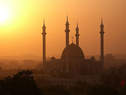
Abuja National Mosque during Harmattan.
Located approximately 300 miles (480 km) northeast of Lagos, in the centre of Nigeria in the Federal Capital Territory, Abuja lies at 1180 feet (360 meters) above sea level and has a cooler climate and less humidity than is found in Lagos.
Abuja's geography is defined by Aso Rock, a 400-metre monolith left by water erosion. "Aso" means "victorious" in the language of the (now displaced) Asokoro ("the people of victory").
Abuja undergoes three weather conditions annually. This includes a warm, humid rainy season, from April to October, and a blistering dry season, when daytime temperatures can soar as high as 40 degrees. In between the two seasons, there is a brief interlude of harmattan occasioned by the North East Trade Wind, with the main feature of dust haze, intensified coldness and dryness. The annual total rainfall is in the range of 1100mm to 1600mm.
Abuja has several parks and green areas with the largest one being Millennium park, which was designed by world renowned architect Manfredi Nicoletti and was officially opened by Queen Elizabeth II of England.
Sights include the Nigerian National Mosque and the Nigerian National Christian Centre. The city is served by the Nnamdi Azikiwe International Airport, while Zuma Rock lies nearby. However, the population on the semi-developed edges of the city are living in shanty towns such as Karu, which was built to house the capital's civil servants and lower income families, and has no running water, sanitation or electricity.
History
Since Nigeria's independence from the United Kingdom, on October 1, 1960, ethnic and religious divisions required the creation of a capital city in a location deemed neutral to all parties. Also, Lagos's population boom made that city overcrowded and conditions squalid.
The site for a new capital was chosen because of its central location, easy accessibility, pleasant climate, low population density, and the availability of land for future expansion.
A consortium of three American firms: PRC Corporation; Wallace, McHarg, Roberts and Todd; and, Archisystems, created a master plan for Abuja. Renowned Japanese architect Kenzo Tange refined the design
Construction began in the late 1970s, but economic and political instability meant the city’s initial stages were not complete until the late 1980s.
Most countries moved their embassies to Abuja and maintain their larger former embassies as consulates in the commercial capital, Lagos.
Administration
The Presidential Complex, National Assembly, Supreme Court and much of the town extend to the south of the rock. Abuja is the headquarters of the Economic Community of West African States (ECOWAS), as well as its military arm, ECOMOG. It also has the regional headquarters of OPEC.
The city’s Phase one districts are: Abuja Central, which is the city's principal Business Zone and includes the National Assembly, the city hall, national cultural institutes, and other government-related offices, Garki, Wuse, Maitama, which is exclusive and is the location of European embassies, and Asokoro. Phase two districts are: Kado, Durumi, Gudu, Utako and Jabi. Phase 3 Districts are: Mabuchi, Katampe, Wuye and Gwarimpa. There are also five suburban districts, which are Nyanya, Karu, Gwagwalada, Kubwa, and Jukwoyi.
Along the Airport Road are clusters of satellite settlements these are namely: Lugbe, Chika, Kuchigworo and Pyakassa. Other satellite settlements are Idu (The Main Industrial Zone), Mpape, Karimu, Gwagwa, Dei-Dei (housing the International Livestock market and also International Building materials market).
Economy
Abuja International Airport is the only airport in Abuja. The airport with an international and local terminal is under going serious upgrades in order to make it ready to host an event such as the Commonwealth games. Abuja also has a running and efficient BRT and green cab system. Construction is underway for an LRT system for the city. Abuja does not as yet have a connection to the national railway network of Nigeria.
Abuja competed with but lost out to Glasgow, Scotland to host the Commonwealth Games in 2014.
Demographics
Abuja and the FCT have experienced a huge population growth; it has been reported that some areas around Abuja have been growing at 20 percent to 30 percent.
General landmarks

Headquarters of the Central Bank of Nigeria in Abuja, Nigeria
- Central Bank of Nigeria headquarters
- Ship house, Ministry of Defence building
- Aso Rock, official residence of the President of Nigeria
- Zuma Rock
- NNPC towers
- Abuja International Conference Centre African Hall
- Gurara Falls
- Eagle Square
- National Assembly building in Abuja
- Central District
- Nigerian Communications Commission building
- Maitama District home of the embassies
- National Library
- National Mosque
- National Ecumenical Centre (National Church)
- Abuja Stadium
- The Velodrome
- Nnamdi Azikwe International Airport
- Strabag Hills
- Usuma Dam
- Usuma River
- Jabi River
- Gurara River
- Abuja Love Garden
- Abuja Amusement Park
- Abuja Zoological Park
- IBB Golf Centre
- Ecowas Secretariat
- National Women Development Centre
- Ushafa Pottery Centre
- Ladi Kwali Pottery Centre
- Giri Pottery Centre
- Millennium park
Malls and shopping centres
- Ceddi Plaza
- Downtown Mall, Abuja (U/C)
- Silverbird Galleria Abuja (U/C)
- Grand Square
- Park 'N Shop
- Sahad Stores
- Maitama Stores
Leisure centres
- National Park and Zoo, Maitama
- Wonderland Amusement Park
Sister Cities
 Brasília, Brazil.
Parks and open areas
Abuja is home several parks and green areas with the largest one being Millennium park. Millennium Park was designed by world renowned architect Manfredi Nicoletti and was officially opened by Queen Elizabeth II of England.
References
ISBN links support NWE through referral fees
External links
Credits
New World Encyclopedia writers and editors rewrote and completed the Wikipedia article
in accordance with New World Encyclopedia standards. This article abides by terms of the Creative Commons CC-by-sa 3.0 License (CC-by-sa), which may be used and disseminated with proper attribution. Credit is due under the terms of this license that can reference both the New World Encyclopedia contributors and the selfless volunteer contributors of the Wikimedia Foundation. To cite this article click here for a list of acceptable citing formats.The history of earlier contributions by wikipedians is accessible to researchers here:
The history of this article since it was imported to New World Encyclopedia:
Note: Some restrictions may apply to use of individual images which are separately licensed.


