Tornado
- This article is about the weather phenomenon. For other uses, see Tornado (disambiguation).
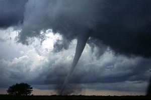
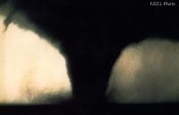
A tornado is a violently rotating column of air which is in contact with both a cumulonimbus (or, in rare cases, cumulus) cloud base and the surface of the earth. Tornadoes can come in many shapes, but are typically in the form of a visible condensation funnel, with the narrow end touching the earth. Often, a cloud of debris encircles the lower portion of the funnel.
Most tornadoes have winds of 110 mph (175 km/h) or less, are approximately 250 feet (75 meters) across, and travel a few miles (several kilometers) before dissipating. However, some tornadoes can have winds of more than 300 mph (480 km/h), be more than a mile (1.6 km) across, and stay on the ground for dozens of miles (more than 100 kilometers).[1][2][3]
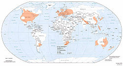
They have been observed on every continent except Antarctica; however, most of the world's tornadoes occur in the United States.[4] Other areas which commonly experience tornadoes include New Zealand, western and southeastern Australia, south-central Canada, northwestern Europe, Italy, south-central and eastern Asia, east-central South America, and Southern Africa.[5]

Definitions
A tornado is defined by the Glossary of Meteorology as "a violently rotating column of air, in contact with the ground, either pendant from a cumuliform cloud or underneath a cumuliform cloud, and often (but not always) visible as a funnel cloud.."[6] A tornado does not necessarily have to be visible; however, the intense low pressure caused by the fast wind speeds (see Bernoulli's principle) and rapid rotation (due to cyclostrophic balance) usually cause water vapor in the air to condense into a visible condensation funnel.[4] Strictly, the term tornado refers to the vortex of wind, connecting to both the surface and a convective cloud above, not the condensation cloud.
A funnel cloud is a low-hanging, vertically rotating cloud, with no associated strong winds at the surface. Funnel clouds are not tornadoes, and not all funnel clouds develop into a tornado. However, many tornadoes are preceded by a funnel cloud aloft in which condensation descends from the parent storm as saturation occurs at progressively lower altitude. It is often difficult to tell the difference between a funnel cloud and a tornado from a distance. Most tornadoes produce strong winds at the surface while the visible funnel is still above the ground. Swirling dust and debris at the surface confirm that a tornadic circulation is on the ground.[3] A shear funnel or cold air vortex is a tiny, harmless funnel which occasionally forms underneath or on the sides of cumuliform clouds.
Tornadoes often develop from a class of thunderstorms known as supercells. Supercells contain mesocyclones, in which rotation is organized. Most intense tornadoes (F3 to F5 on the Fujita Scale) develop from supercells. Very heavy rain, frequent lightning, strong wind gusts, and hail are also common in such storms. The largest hail generally comes from supercells, as a very strong and rotating updraft is usually required to suspend such large hailstones aloft.
Stronger tornadoes are also those most observed to have multiple vortices (or, subvortices) in which two or more columns of spinning air rotate around a common center. Multivortex structure occurs in smaller tornadoes, and large weak tornadoes, as well as other circulations. A satellite tornado is a term for a weaker tornado which forms very near a large, strong tornado contained within the same mesocyclone. The satellite tornado may appear to "orbit" the larger tornado (hence the name), giving the appearance of one, large multi-vortex tornado. However, a satellite tornado is a distinct funnel, and is much smaller than the main funnel.[3]. Occasionally a single storm may produce multiple tornadoes and mesocyclones. This process is known as cyclic tornadoegenesis. Tornadoes produced from the same storm are referred to as a tornado family [7].
Occasionally, many tornadoes are spawned from the same general storm system. While there is no single agreed upon definition, multiple tornadoes spawned by the same general storm system with no break in activity for 6 to 24 hours (depending on definition in use) is considered a tornado outbreak. The qualifying numbers vary. Currently, for the United States, about ten tornadoes constitutes an outbreak. When there is a break of activity for more than 6 to 24 hours, it usually is considered a separate outbreak. If spawned from the same general system, it may be referred to as an extended tornado outbreak. A period of at least several successive days of continuous or near continuous very high tornado activity consisting of a series of tornado outbreaks (spawned by multiple weather systems) is a tornado outbreak sequence, occasionally called an extended tornado outbreak.
A waterspout is a tornado over water. Most scientists consider all waterspouts—including "fair weather" waterspouts—to be tornadoes. Although the National Weather Service considers waterspouts as a tornadic meteorological phenomenon, waterspouts are not counted in official records unless they strike land. "Fair weather" waterspouts are less-severe relatives of classic tornadoes. They are almost always weak (F0 or F1 on the Fujita Scale), and spawn from non-rotating thunderstorms or even ordinary summer showers. Typically, when such waterspouts move onto land they cause little or no damage, and dissipate within minutes. However, strong waterspouts from supercells can cause significant damage. In addition, strong tornadoes can move over lakes or over the ocean, becoming waterspouts, without losing intensity.
A landspout is an unofficial term for a tornado not associated with a mesocyclone. Landspouts most often are weak, featuring a small condensation funnel which often does not appear to reach the ground, and are often marked by a tall tube of dust and/or debris reaching as far up as the parent cloud. Though usually weaker than classic tornadoes, they are tornadoes, and can cause serious damage.[3][8]
A gustnado is a small, vertical swirl associated with a gust front or downburst. Because they are technically not associated with the cloud base, there is some debate as to whether or not gustnadoes are actually tornadoes.[3] [9] These usually cause localized areas of heavier damage among areas of straight-line wind damage caused by the gust front.
A dust devil resembles a tornado in that it is a vertical swirling column of air. Dust devils form under clear skies and are rarely as strong as even the weakest tornadoes. They are not considered tornadoes because they form during fair weather and are not associated with convective clouds. However, they can, on occasion, result in major damage and fatalities, especially in arid areas.[10] [11]
Tornado-like circulations occasionally occur near large, intense wildfires and are called fire whirls. They are not considered tornadoes except in the rare case where they connect to a pyrocumulus or other cumuliform cloud above. Fire whirls usually are not as strong as tornadoes associated with thunderstorms, however, they can produce significant damage.[12]
Etymology
The word "tornado" is an altered form of the Spanish word tronada, which means "thunderstorm". This in turn was taken from the Latin tonare, meaning "to thunder". It most likely reached its present form through a combination of the Spanish tronada and tornar ("to turn"); however, this may be a folk etymology.[13][14] Some common, related slang terms include: twister, whirlwind, cyclone, funnel, wedge, tube, finger of God, Devil's tail, rope, or stovepipe.

Life cycle
- Further information: Tornadogenesis
Most tornadoes follow a recognizable life cycle.[8] The cycle begins when a strong thunderstorm develops a rotating mesocyclone a few miles up in the atmosphere, becoming a supercell. As rainfall in the storm increases, it drags with it an area of quickly descending air known as the rear flank downdraft (RFD). This downdraft accelerates as it approaches the ground, and drags the rotating mesocyclone towards the ground with it.
As the mesocyclone approaches the ground, a visible condensation funnel appears to descend from the base of the storm, often from a rotating wall cloud. As the funnel descends, the RFD also reaches the ground, creating a gust front that can cause damage a good distance from the tornado. Usually, the funnel cloud begins causing damage on the ground (becoming a tornado) within minutes of the RFD reaching the ground.
Initially, the tornado has a good source of warm, moist inflow to power it, so it grows until it reaches the mature stage. During its mature stage, which can last anywhere from a few minutes to more than an hour, a tornado often causes the most damage, and can in rare instances be more than one mile across. Meanwhile, the RFD, now an area of cool surface winds, begins to wrap around the tornado, cutting off the inflow of warm air which feeds the tornado.
As the RFD completely wraps around and chokes off the tornado's air supply, the tornado begins to weaken, becoming thin and rope-like. This is the dissipating stage, and the tornado often fizzles within minutes. During the dissipating stage, the shape of the tornado becomes highly influenced by the direction of surface winds, and can be blown into fantastic patterns.
As the tornado enters the dissipating stage, its associated mesocyclone often weakens as well, as the rear flank downdraft cuts off the inflow powering it. In particularly intense supercells, tornadoes can develop cyclically. As the first mesocyclone and associated tornado dissipate, the storm's inflow is concentrated into a new area closer to the center of the storm. If a new mesocyclone develops, the cycle may start again, producing a new tornado. Occasionally, the old, or occluded mesocyclone, and the new mesocyclone produce a tornado at the same time.
Though this is a widely-accepted theory for how most tornadoes form, live, and die, it does not explain the formation of smaller tornadoes, such as landspouts, long-lived tornadoes, or tornadoes with multiple vortices. These each have different mechanisms which influence their development—however, most tornadoes follow a pattern similar to this one.[15]
Characteristics

Shape
Most tornadoes take on the appearance of a narrow funnel, a few hundred yards across, with a small cloud of debris near the ground. However, tornadoes can appear in many shapes and sizes.
Small, relatively weak landspouts may only be visible as a small swirl of dust on the ground. While the condensation funnel may not extend all the way to the ground, if associated surface winds are greater than 40 mph (64 km/h), the circulation is considered a tornado.
Large single-vortex tornadoes can look like large wedges stuck into the ground, and are known as wedge tornadoes or wedges. A wedge can be so wide that it appears to be a block of dark clouds. Even experienced storm observers may not be able to tell the difference between a low-hanging cloud and a wedge tornado from a distance.
Tornadoes in the dissipating stage can resemble narrow tubes, or ropes, that often curl or twist into complex shapes. These tornadoes, such as the one pictured at right, are roping out, or becoming a rope tornado. Multiple-vortex tornadoes can appear as a family of swirls circling a common center, or may be completely obscured by condensation, dust, and debris, appearing to be a single funnel.
In addition to these appearances, tornadoes may be obscured completely by rain or dust. These tornadoes are especially dangerous, as even experienced meteorologists might not spot them.[10]
Size
In the United States, an average tornado is around 500 feet (150 m) across, and stays on the ground for 5 miles (8 km). While this is the average, there is an extremely wide range of tornado sizes, even for typical tornadoes.
Weak tornadoes, or strong but dissipating tornadoes, can be exceedingly narrow, sometimes only a few feet across. In fact, a tornado was once reported to have a damage path only 7 feet (2 m) long.[10]
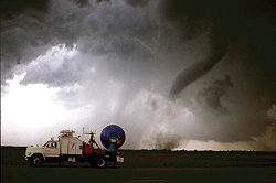
On the other end of the spectrum, wedge tornadoes can have a damage path a mile (1.6 km) wide or more. A tornado which affected Hallam, Nebraska on May 22, 2004 was at one point 2.5 miles (4 km) wide[2]. The largest wind field documented in a tornado was measured by a Doppler On Wheels (DOW) radar in the Mulhall Tornado on 3 May 1999. The core flow region (enclosed by the maximum wind velocities on each side of the tornado) was large as 1600 m across and the region of potentially damaging winds over 43 m/s was 7 km across. (Wurman 2002, Monthly Weather Review)(Wurman et al. 2007, Bull. Am. Met. Soc)[citation needed]
In terms of path length, some meteorologists believe that the Tri-State Tornado, which affected parts of Missouri, Illinois, and Indiana on March 18, 1925, was on the ground continuously for 219 miles (352 km). However, without a modern damage survey, it is impossible to determine whether or not the deadly event was a single tornado or a series of violent tornadoes produced by the same storm. The longest modern-day damage path was caused by a tornado which was on the ground for 160 miles (260 km) in northeastern North Carolina on November 22, 1992.[16]
Appearance
Tornadoes, depending on the environment in which they form, can have a wide range of colors. Tornadoes which form in a dry environment can be nearly invisible, marked only by swirling debris at the base of the funnel. Condensation funnels which pick up little or no debris can be grey to white. While travelling over a body of water as a waterspout, they can turn very white or even blue. Funnels which move slowly, ingesting a lot of debris and dirt, are usually darker, taking on the color of debris. Tornadoes in the Great Plains can turn red because of the reddish tint of the soil, and tornadoes in mountainous areas can travel over snow-covered ground, turning brilliantly white in the process.
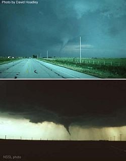
Lighting conditions are also a major factor in the appearance of a tornado. A tornado which is "back-lit", or viewed with the sun behind it, will appear to be very dark. The same tornado, viewed with the sun at the observer's back, may appear grey or brilliant white. Tornadoes which occur near the time of sunset can be many different colors, appearing in hues of yellow, orange, and pink.[18]
Dust kicked up by the winds of the parent thunderstorm, heavy rain and hail, and the darkness of night are all factors which can reduce the visibility of tornadoes, making them "invisible", in essence. Tornadoes occurring in these conditions are especially dangerous, since only radar observations, or possibly the sound of an approaching tornado, serve as any warning to those in the storm's path. Fortunately most significant tornadoes form under the storm's rain-free base, or the area under the thunderstorm's updraft, where there is little or no rain. In addition, most tornadoes occur between the hours of 4 and 8 pm, when the bright sun can penetrate even the thickest clouds. Also, night-time tornadoes are often illuminated by frequent lightning.
There is mounting evidence, including DOW mobile radar images[19] and eyewitness accounts[20], which suggest that most tornadoes have a clear, calm center with extremely low pressure, akin to the eye found in tropical cyclones. This area would be clear (possibly full of dust), have relatively light winds, and be very dark, with the light blocked out by swirling debris on the outside of the tornado. Lightning is said to be the source of illumination for those who claim to have seen the interior of a tornado.
Rotation
Tornadoes normally rotate in a cyclonic direction (counterclockwise in the northern hemisphere). Large-scale storms always rotate cyclonically because of the Coriolis effect; however, tornadoes are too small in scale to be directly affected by the rotation of the earth. Approximately 1 tornado in 100 rotates in an anticyclonic direction. Typically, only landspouts and gustnados also rotate anticyclonically. Anticyclonic tornadoes often form on the anticyclonic shear side of the descending RFD in a cyclonic supercell, usually south or southeast of the main cyclonic circulation associated with the mesocyclone for a typical right-moving supercell in the Northern Hemisphere. [21] Also, on very rare occasions, anticyclonic tornadoes can presumably form in association with the mesoanticyclone of an anticyclonic (left-moving) supercell, in the same manner as the more typical cyclonic tornado. [22]
Intensity and damage
The Fujita scale rates tornadoes by damage caused. An F0 tornado will likely damage trees but not structures, whereas an F5 tornado can rip buildings off their foundations and even tear asphalt from the ground. The similar TORRO scale ranges from a T0 for extremely weak tornadoes to T11 for the most powerful known tornadoes.
Tornadoes vary in intensity regardless of shape, size, and location, though strong tornadoes are typically larger than weak tornadoes.
In the United States, F0 and F1 (T0 through T3) tornadoes account for 80% of all tornadoes. The rate of occurrence drops off quickly with increasing strength—violent tornadoes (stronger than F4, T8), account for less than 1% of all tornado reports.[23] Outside of the United States and areas in south-central Asia, significant and violent tornadoes are extremely rare.
Prediction
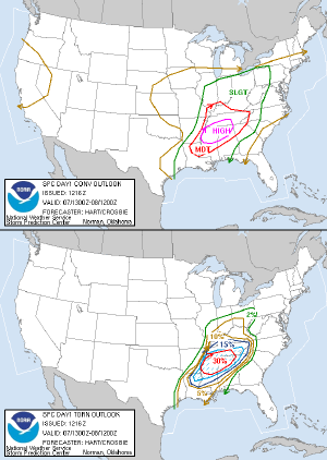
The following organizations provide official or de facto official tornado and severe convective storm forecasts and warnings.
Australia
Severe thunderstorm warnings are provided to Australia by their Bureau of Meteorology. The country is in the middle of an upgrade to Doppler radar systems, with their first benchmark of installing six new radars reached in July 2006. [24]
Canada
In Canada, weather forecasts and warnings, including tornadoes, are produced by the Meteorological Service of Canada division of Environment Canada.
Europe
The European Union founded a project in 2002 called the European Severe Storms virtual Laboratory, or ESSL, which is meant to fully document tornado occurrence across the continent. The ESTOFEX (European Storm Forecast Experiment) arm of the project also issues one day forecasts for severe weather likelihood. [25]
Germany, Austria, and Switzerland
An organization known as TorDACH was founded in 1997 to collect information regarding tornadoes, waterspouts, and downbursts from Germany, Austria, and Switzerland. A secondary goal is collect all severe weather information. This project is meant to document fully severe weather activity in these three countries.[26]
Japan
In Japan, predictions and study of tornadoes in Japan are handled by the Japan Meteorological Agency.
United Kingdom
In the United Kingdom, the Tornado and Storm Research Organisation (TORRO) makes experimental predictions.
United States
In the United States, generalized severe weather predictions are issued by the Storm Prediction Center, based in Norman, Oklahoma. For the next one, two, and three days, respectively, they will issue categorical and probabilistic forecasts of severe weather, including tornadoes. There is also a more general forecast issued for the four to eight day period. Just prior to the expected onset of an organized severe weather threat, SPC issues severe thunderstorm and tornado watches, in collaboration with local National Weather Service offices. Warnings are issued by local National Weather Service offices when a severe thunderstorm or tornado is occurring or imminent.
Detection
The National Weather Service trains Skywarn spotters, consisting of local sheriff's deputies, state troopers, firefighters, amateur radio operators, storm chasers, and ordinary citizens, to spot key features of storms which indicate severe hail, strong winds, and tornadoes. When severe weather is anticipated, local weather service offices request that these spotters be on the lookout for severe weather, and report any possible tornadoes immediately, so the office can issue a timely warning.
Doppler weather radar stations are used, mainly in the United States, as the main detection method for tornadoes. These devices are capable of measuring the velocity and radial direction (towards or away from the radar) of the winds in a storm, and so can spot rotating supercells from hundreds of miles away.
Climatology
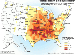
The United States has the most tornadoes of any country, seeing about four times the activity estimated in all of Europe. This is mostly due to the unique geography of the continent. North America is a relatively large continent that extends from the tropical south into arctic areas, and has no major east-west mountain range to block air flow between these two areas. This unique topography allows for many collisons of warm and cold air; creating the conditions necessary to breed strong, long-lived storms which occur many times a year. A large portion of these tornadoes form in an area of the central United States known as Tornado Alley.[4] This area extends into Canada, particularly Ontario and the Prairie Provinces. The Netherlands has the highest average number of recorded tornadoes per area of any country (more than 20 annually), followed by the UK (around 50 per year)[27], but most are small and result in minor damage. The UK experiences more tornadoes than any other European country.
Bangladesh and surrounding areas of eastern India suffer from tornadoes of equal severity to those in the US with more regularity than any other region in the world, however these occur with a greater recurrence interval, and tend to be under-reported due to the scarcity of media coverage in a third-world country. The annual human death toll is about 179 deaths per year from tornadoes in Bangladesh, which is much greater than in the US. This is likely due to the density of population, poor quality of construction, lack of tornado safety knowledge, and other factors.[28].
Other areas of the world that have more frequent strong tornadoes include parts of Argentina and southern Brazil as well as South Africa. A fair number of weak and occasionally strong tornadoes occurs annually in Germany, Italy, Spain and China. Australia, France, Russia, areas of the Middle East, and Japan have a history of multiple damaging tornado events.
Tornadoes can form in any month, providing the conditions are favorable. They are least common during the winter and most common in spring. Since autumn and spring are transitional periods (warm to cool and vice versa) there are more chances of cooler air meeting with warmer air, resulting in thunderstorms. Tornadoes in the late summer and fall can also be caused by hurricane landfall.
Tornado occurrence is highly dependant on the time of day. [29] Austria, Finland, Germany, and the United States'[30] peak hour of occurrence is 5 p.m., with roughly half of all tornado occurrence between 3 p.m. and 7 p.m. local time.[31][32] However, destructive tornadoes can occur at any time of day. The Gainesville Tornado of 1936, one of the deadliest tornadoes in history, occurred at 8:30AM local time.
Extremes
Tornadoes are the most violent weather events in the world. As such, they have been recorded to produce some incredible phenomena.
In terms of the most extreme tornado in history, the honor undoubtedly goes to the Tri-State Tornado which roared through parts of Missouri, Illinois, and Indiana on March 18, 1925. This tornado, likely an F5 (though this was before the era where tornadoes were ranked on the Fujita scale), set (and still holds) records for the deadliest single United States tornado (695 dead), longest path length (219 miles, 352 km), longest duration (about 3.5 hours), and fastest forward speed for a significant tornado (73 mph, 117 km/h). It was also the second costliest tornado in history at the time, but has since been surpassed by several others non-normalized, it still ranks third when normalized for wealth and inflation.[33]
The deadliest tornado in world history occurred on April 26, 1989 in Bangladesh, killing approximately 1300 people. [28]
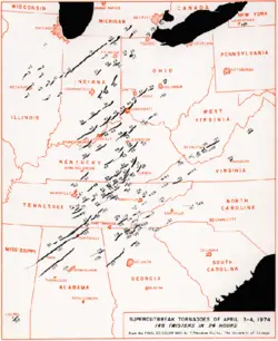
The most extensive tornado outbreak on record, in almost every category, was the Super Outbreak, which affected a large area of the Central United States and extreme southern Ontario in Canada on April 3 and 4, 1974. Not only did this outbreak feature an incredible 148 tornadoes in only 18 hours, but an unprecedented amount of them were violent; six of the tornadoes were of F5 intensity, and 24 were of F4 intensity. More than 300 people, possibly as many as 330, were killed by tornadoes during this outbreak.
While it is nearly impossible to directly measure the most violent tornado wind speeds (conventional anemometers would be destroyed by the intense winds), some tornadoes have been scanned by mobile doppler radar units, which can provide a good estimate of the tornado's winds. The highest wind speed ever measured in a tornado, which is also the highest wind speed ever recorded on the planet, is 301 ± 20 mph (484 ± 32 km/h) in the F5 Moore, Oklahoma tornado. Though the reading was taken about 100 feet (30 m) above the ground, this is a testament to the power of the strongest tornadoes.
Storms which produce tornadoes can feature intense updrafts (sometimes exceeding 150 mph, 240 km/h). As such, debris from a tornado can be lofted into the parent storm, and be carried for very long distances. A tornado which affected Great Bend, Kansas in November, 1915 was an extreme case, where a "rain of debris" occurred 80 miles (130 km) from the town, a sack of flour was found 110 miles (177 km) away, and a cancelled check from the Great Bend bank was found in a field outside of Palmyra, Nebraska, 305 miles (491 km) to the northeast.[34]
Tornado safety
Though tornadoes can strike in an instant, there are precautions and preventative measures that you can take in order to increase the chances of surviving a tornado. Authorities such as the Storm Prediction Center advise having a tornado plan. When a tornado warning is issued, going to a basement or an interior first-floor room of a sturdy building greatly increases chances of survival.[35] In tornado-prone areas, many buildings have storm cellars on the property. These underground refuges have saved thousands of lives.[36]
Some countries have meteorological agencies which distribute tornado forecasts and increase levels of alert of a possible tornado (such as tornado watches and warnings in the United States and Canada). Weather radios provide alarm when increased tornadic threat is detected for your local area, though these are mainly available only in the United States.
Unless the tornado is far away, meteorologists advise that drivers park their vehicles far to the side of the road (so as not to block emergency traffic), and find a sturdy shelter. If no sturdy shelter is nearby, getting low in a ditch is the next best option. Highway overpasses are extremely bad shelter during tornadoes (see next section).
Myths and misconceptions
One of the most persistent myths associated with tornadoes is that opening windows will lessen the damage caused by the tornado. While it is true that there is a large drop in atmospheric pressure inside a strong tornado, it is unlikely that the pressure drop would be enough to cause the house to explode. In fact, some research indicates that opening windows may indeed increase the severity of the tornado's damage. Regardless of the validity of the explosion claim, however, time would be better spent seeking shelter before a tornado than opening windows.[37]
Another commonly held belief is that highway overpasses provide adequate shelter from tornadoes. On the contrary, a highway overpass is a very dangerous place to be during a tornado. During the Oklahoma Tornado Outbreak of May 3, 1999, three highway overpasses were directly struck by tornadoes, and at all three there was a fatality, along with many life-threatening injuries.[38] During the same tornado outbreak, more than 2000 homes were completely destroyed, with another 7000 damaged, and yet only a few dozen people died in their homes.[39] Similarly, an old belief was that the southwest corner of a basement provides the most protection during a tornado. In actuality, the northeast corner of a building is the safest, and taking shelter under a sturdy table, in a basement, or under a staircase increases chances of survival even more.[37]
Finally, there are areas which people believe to be protected from tornadoes, whether by a major river, a hill or mountain, or even protected by "spirits". All of these are untrue assumptions, as tornadoes have been known to cross major rivers, climb mountains, and affect valleys. As a general rule, no area is "safe" from tornadoes, though some areas are more susceptible than others (see the Geography section).[37][10]
Continuing research
Though scientists have learned much from years of research, there are still many things about tornadoes which remain a mystery. [40] In fact, scientists still don't know the exact method by which most tornadoes form. Research programs, including VORTEX, deployment of TOTO (the TOtable Tornado Observatory), and dozens of other programs, hope to solve many questions that still plague meteorologists.[41]
Social implications of tornadoes
Tornado damage to man-made structures is a result of the high wind velocity and windblown debris. Tornadic winds have been measured in excess of 300 mph (480 km/h). Tornadoes are a serious hazard to life and limb. As such, people in tornado-prone areas often adopt plans of action in case a tornado approaches.
Storm cellars are often used as a means of shelter in case of tornadoes or tropical cyclones. Common in tornado-prone areas, they have been around for more than 100 years—even referenced in the famous 1930s film The Wizard of Oz. Consisting either of a simple underground room, or an elaborate above-ground bunker, they are usually small rooms, designed to keep debris from entering and causing injury. When properly constructed, they can survive an F5 tornado. While it is unknown how many lives have been saved by storm cellars, the number is undoubtedly high.[42]
Some individuals and hobbyists, known as storm chasers, enjoy pursuing thunderstorms and tornadoes to explore their many visual and scientific aspects. Attempts have been made by some storm chasers from educational and scientific institutions to drop probes in the path of oncoming tornadoes in an effort to analyze the interior of the storms, but only about five drops have been successful since around 1990.
Due to the relative rarity and large scale of destructive power that tornadoes possess, their occurrence or the possibility that they may occur can often create what could be considered sensationalism in their reporting. This results in so-called weather wars, in which competing local media outlets, particularly TV news stations, engage in continually escalating technological one-upsmanship and drama in order to increase their market share. This is especially evident in tornado-prone markets, such as those in the Great Plains.
According to Environment Canada, the chances of being killed by a tornado are 12 million to 1 (12,000,000:1). One may revise this yearly and/or regionally, but the probability may be factually stated to be low. Regardless, tornadoes cause millions of dollars in damage, both economic and physical, many deaths, and hundreds of injuries every year.[16] [43]
Cultural significance
Tornadoes as a metaphor
The tornado has been used by cartoonists for over 100 years as a metaphor for political upheaval. For example, according to political interpretations of The Wonderful Wizard of Oz, the tornado takes Dorothy to a utopia, the Land of Oz, and kills the Wicked Witch of the East, who had oppressed "the little people", the Munchkins.[44] The storm cellar has also been used as a metaphor for seeking safety, as shown in the cartoon from 1894 at right.
A 1960s advertising campaign for the household cleaner, Ajax, claimed the product "Cleans like a white tornado".
Tornadoes in dreams are sometimes said to be associated with fear, chaos, and upheaval. It is alleged that the location where one is during a tornado dream, e.g. at home, can help to determine the meaning.[45]
Motion pictures with a tornado theme
- The Wizard of Oz, 1939.
- Mr. and Mrs. Bridge, 1990.
- Night of the Twisters (TV), 1996.
- Tornado! (TV), 1996.
- Twister, 1996.
- Atomic Twister (TV), 2001.
- The Day After Tomorrow, 2004.
- Category 7: The End of the World, 2005.
- Perfect Disaster: Super Tornado (Discovery Channel), premiered on March 19, 2006.
See also
- Cyclone
- Derecho
- Downburst
- Dust devil
- Emergency Alert System
- Funnel cloud
- Fujita Scale
- History of tropical cyclone-spawned tornadoes
- List of F5 tornadoes
- List of tornadoes and tornado outbreaks
- List of tornado-related deaths at schools
- Mesocyclone
- Multiple vortex tornado
- NLM Cityhopper Flight 431
- Severe weather
- Supercell
- Tornado records
- Tornadoes of 2006
ReferencesISBN links support NWE through referral fees
- ↑ Center for Severe Weather Research (2006). Doppler On Wheels. Retrieved 2006-12-29.
- ↑ 2.0 2.1 Omaha/Valley, NE Weather Forecast Office (2005-10-02). Hallam Nebraska Tornado. Retrieved 2006-09-08. Cite error: Invalid
<ref>tag; name "widest tornado" defined multiple times with different content - ↑ 3.0 3.1 3.2 3.3 3.4 Edwards, Roger (2006-04-04). The Online Tornado FAQ. Storm Prediction Center. Retrieved 2006-09-08.
- ↑ 4.0 4.1 4.2 Perkins, Sid (2002-05-11). Tornado Alley, USA. Science News pp. 296-298. Retrieved 2006-09-20.
- ↑ Encyclopædia Britannica Online (2006). Tornado occurrence and distribution. Retrieved 2006-09-20.
- ↑ American Meteorological Society (2000). Glossary of Meteorology, Second Edition (html). American Meteorological Society. Retrieved 2006-11-17.
- ↑ [1]
- ↑ 8.0 8.1 Cite error: Invalid
<ref>tag; no text was provided for refs namedAdvanced Spotter Guide - ↑ American Meteorological Society. Gustnado. Glossary of Meteorology. Retrieved 2006-09-20.
- ↑ 10.0 10.1 10.2 10.3 Lyons, Walter A. The Handy Weather Answer Book. Detroit, MI: Visible Ink Press, 1997.
- ↑ Charles H. Jones; Charlie A. Liles (1999). SEVERE WEATHER CLIMATOLOGY FOR NEW MEXICO. Retrieved 2006-09-29.
- ↑ Grazulis, Thomas P. Significant Tornadoes 1680-1991. A Chronology and Analysis of Events. St. Johnsbury, VT: The Tornado Project of Environmental Films, 1993.
- ↑ Harper, Douglas (November 2001). Online Etymology Dictionary. Retrieved 2006-09-20.
- ↑ Webster's New World College Dictionary
- ↑ Markowski, Straka, and Rasmussen (2002-10-14). Tornadogenesis Resulting from the Transport of Circulation by a Downdraft: Idealized Numerical Simulations. Journal of the Atmospheric Sciences: Vol. 60, No. 6 pp. 28. Retrieved 2006-09-13.
- ↑ 16.0 16.1 Data from the Storm Prediction Center archives, which are accessible through SeverePlot, free software created and maintained by John Hart, lead forecaster for the SPC.
- ↑ Edwards, Roger. Public Domain Tornado Images. National Severe Storms Laboratory. Retrieved 2006-10-20.
- ↑ Lloyd, Linda Mercer. (1996). Target: Tornado [Videotape]. Atlanta, Georgia: The Weather Channel Enterprises, Inc..
- ↑ R. Monastersky (1999-05-15). Oklahoma Tornado Sets Wind Record. Science News pp. 308-309. Retrieved 2006-10-20.
- ↑ Justice, Alonzo A (May 1930). Seeing the Inside of a Tornado (PDF). Monthly Weather Review pp. 205-206. American Meteorological Society. Retrieved 2006-10-20.
- ↑ Forbes, Greg. weather.com - Blog: The Weather Channel on weather news, hurricanes, tornadoes & meteorology. Retrieved 2006-12-30.
- ↑ Monteverdi, John (2003-01-25). Sunnyvale and Los Altos, CA Tornadoes May 4, 1998. Retrieved 2006-10-20.
- ↑ Edwards, Moller, Purpura et al (2005). Basic Spotters’ Field Guide (PDF). US Department of Commerce, National Weather Service. Retrieved 2006-11-01.
- ↑ Bureau of Meteorology. Severe Thunderstorm Warning Service in NSW and the ACT. Retrieved on 2006-10-25.
- ↑ ESSL. European Severe Storms virtual Laboratory, ESSL. Retrieved on 2006-10-25.
- ↑ TorDACH. TorDACH Homepage. Retrieved on 2006-10-25.
- ↑ BBC News (2006). Six hurt as tornado hits London. Retrieved 2006-12-07.
- ↑ 28.0 28.1 Paul, Bhuiyan (2004). The April 2004 Tornado in North-Central Bangladesh: A Case for Introducing Tornado Forecasting and Warning Systems. Retrieved 2006-08-17.
- ↑ Kelly, Schaefer, McNulty, et al. (1978-04-10). An Augmented Tornado Climatology (PDF). Monthly Weather Review pp. 12. Retrieved 2006-09-13.
- ↑ Encyclopaedia Britannica. Tornadoes. Retrieved on 2006-10-25.
- ↑ A. M. Holzer. Tornado Climatology of Austria. Retrieved on 2006-10-25.
- ↑ N. Dotzek. Tornadoes in Germany. Retrieved on 2006-10-25.
- ↑ Normalized Damage from Major Tornadoes in the United States: 1890-1999
- ↑ Oddities
- ↑ Tornado Safety
- ↑ Storm Shelters (PDF)
- ↑ 37.0 37.1 37.2 [2]
- ↑ http://www.usatoday.com/weather/resources/basics/tornado-underpass.htm]
- ↑ [3]
- ↑ "VORTEX: Unraveling the Secrets." National Severe Storms Laboratory.
- ↑ [4]
- ↑ http://www.usatoday.com/weather/resources/safety/saferoom.htm
- ↑ Environment Canada (2004). Tornadoes. Retrieved 2007-01-17.
- ↑ Quentin P. Taylor (2004-12-02). Money and Politics in the Land of Oz. The Independent Institute. Retrieved 2006-10-24.
- ↑ http://www.jeremytaylor.com/pages/tornadoes_storms.html
Further reading
- Thomas P. Grazulis (1993). Significant Tornadoes 1680-1991, A Chronology and Analysis of Events. The Tornado Project of Environmental Films. ISBN 1-879362-00-7
External links
- General
- Storm archives (including tornadoes since 1950)
- Real Time storm reports overlaid on Google Maps.
- United States Year to date tornado reports.
- The Tornado Project
- NWS Jet Stream Online Weather School
- Birth of a Tornado ~ Animation from MSNBC Interactive
- Tornado Newspaper Articles Archive Free archive of more than 50,000 newspaper articles detailing tornadoes through out history.
- The Tornado History Project
- Severe Weather UK
- Regional prediction
- Storm Prediction Center (United States)
- The Tornado and Storm Research Organisation (United Kingdom)
- European Severe Storms Laboratory
- Research
- Tornado research and education (National Severe Storms Laboratory)
- U.S. Severe Weather and Meteorology and Climatology
- TorDACH: Centre of Competence for Severe Local Storms in D, A, CH (Central Europe)
- Electronic Journal of Severe Storms Meteorology
- Images and Video
- Tornado images (Public Domain)
- National Severe Storms Laboratory Photo Album
- National Weather Service Historical Image Collection
- Collection of tornado pictures with safety and other information
- Video of a tornado forming and lifting a house off the ground (WMV)
- Safety and Preparedness
- NOAA Tornado Preparedness Guide
- Tornado Safety (The Tornado Project)
- Tornado Preparedness Tips for School Administrators (NOAA / SPC)
- Highway Overpasses as Tornado Shelters: Fallout from the May 3, 1999 Tornado Outbreak (National Weather Service, Norman, Oklahoma)
- FEMA for Kids: Tornado
- Miscellaneous
Credits
New World Encyclopedia writers and editors rewrote and completed the Wikipedia article in accordance with New World Encyclopedia standards. This article abides by terms of the Creative Commons CC-by-sa 3.0 License (CC-by-sa), which may be used and disseminated with proper attribution. Credit is due under the terms of this license that can reference both the New World Encyclopedia contributors and the selfless volunteer contributors of the Wikimedia Foundation. To cite this article click here for a list of acceptable citing formats.The history of earlier contributions by wikipedians is accessible to researchers here:
The history of this article since it was imported to New World Encyclopedia:
Note: Some restrictions may apply to use of individual images which are separately licensed.
