Difference between revisions of "Jirisan" - New World Encyclopedia
Dan Davies (talk | contribs) (imported, credited, claimed) |
Dan Davies (talk | contribs) |
||
| Line 59: | Line 59: | ||
7:20 7:45 8:40 9:10 10:00 11:10 12:10 12:40 13:35 14:10 15:20 16:10 17:35 | 7:20 7:45 8:40 9:10 10:00 11:10 12:10 12:40 13:35 14:10 15:20 16:10 17:35 | ||
==See also== | ==See also== | ||
| − | * [[National | + | * [[National parks of South Korea]] |
* [[List of Korea-related topics]] | * [[List of Korea-related topics]] | ||
* [[List of mountains in Korea]] | * [[List of mountains in Korea]] | ||
| Line 66: | Line 66: | ||
[[Category:Mountains of South Korea]] | [[Category:Mountains of South Korea]] | ||
[[Category:South Jeolla]][[Category:North Jeolla]][[Category:South Gyeongsang]] | [[Category:South Jeolla]][[Category:North Jeolla]][[Category:South Gyeongsang]] | ||
| − | |||
| − | |||
| − | |||
== External links == | == External links == | ||
Revision as of 18:02, 6 August 2007
| Jirisan | |
|---|---|

| |
| Korean Name | |
| Hangul | 지리산 |
| Hanja | 智異山 |
| Revised Romanization | Jirisan |
| McCune-Reischauer | Chirisan |
| Elevation: | 1,915 metres (6,283 feet) |
| Coordinates: | 35°20′N 127°43′E |
| Location: | South Korea |
| Easiest route: | hike |
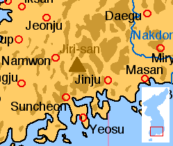
Jirisan is a mountain in the southern region of South Korea. It is often considered one of the three most important mountains in South Korea, with Hallasan and Seoraksan being the other two.
The mountain rises to 1915 metres above sea level and is located in a designated national park of the same name. Jirisan National Park spans three provinces: North, South Jeolla and South Gyeongsang and is the largest in Korea. The largest proportion of the national park is in the province of South Gyeongsang. The highest peak of the mountain, Cheonhwangbong is also located in this province. Another well-known peak is Samshin-bong (Three Spirits Peak).
Jirisan is considered the southern end of the Sobaek mountain range, and therefore also the southern end of the Baekdudaegan mountain range, the "spine" of the Korean Peninsula incorporating the Sobaek mountain range and most of the Taebaek mountain range.
There are seven Buddhist temples on Jirisan that are considered major Buddhist temples. Hwaeomsa is the largest and best-known temple among these, and contains a number of national treasures (mostly stone artworks from about 600-900 C.E.). The mountain is also home to the Cheonghak-dong (Azure Crane Village) alpine valley, which includes the Samseong-gung (Three Sages Palace), which is a recently-developed site to celebrate one of Korea's foundation myths.
- Chirisan.jpg
Jirisan National Park
- ChirisanPoint.jpg
Jirisan Point
Peaks
Samshinbong (bong means 'peak') is 1,284 meters high and a popular, but strenuous, day-hike from the Ssanggye Temple entry point (it is the closest major peak from this trailhead). From Ssanggyesa, a trail winds up 2.3km to Buril Falls. From the left turn in the path just before the waterfall, the track continues 6.9km to the peak(for a grand round-trip total of 18.4km). Starting from Ssanggyesa (the sa suffix indicates a Buddhist temple), you can reach the peak in 4 hours at a steady pace. It takes about 3 hours to get down; it's an extremely steep hike. Bring plenty of water as it is not available beyond the temple grounds. Creeks in the vicinity are not safe to drink from without purification or filtering. Giardia lamblia, a water-bourne parasite, is found in South Korean streams, along with other parasites and pathogens.
GETTING THERE
Buses depart regularly from Busan's Seobu Terminal at Sasang for Hadong, the south-eastern entry point into the park. Fare: W9,900
From the Hadong Bus Station, take a bus to Ssanggye-sa. Fare: W2,200
Bus Timetable
Hadong to Ssangyesa 8:00 9:50 10:55 11:40 12:40 13:50 14:50 15:30 16:45 17:30 18:40 20:40
Ssangyesa to Hadong (buy tickets at the restaurant next to the stone bridge leading to Ssangyesa) 7:20 7:45 8:40 9:10 10:00 11:10 12:10 12:40 13:35 14:10 15:20 16:10 17:35
See also
- National parks of South Korea
- List of Korea-related topics
- List of mountains in Korea
- Geography of South Korea
External links
- Jiri-san as a Sacred Mountain, Mason's pages on the religious character and sites of this remarkable set of peaks, slopes and gorges.
Credits
New World Encyclopedia writers and editors rewrote and completed the Wikipedia article in accordance with New World Encyclopedia standards. This article abides by terms of the Creative Commons CC-by-sa 3.0 License (CC-by-sa), which may be used and disseminated with proper attribution. Credit is due under the terms of this license that can reference both the New World Encyclopedia contributors and the selfless volunteer contributors of the Wikimedia Foundation. To cite this article click here for a list of acceptable citing formats.The history of earlier contributions by wikipedians is accessible to researchers here:
The history of this article since it was imported to New World Encyclopedia:
Note: Some restrictions may apply to use of individual images which are separately licensed.