Gulf of Mexico

The Gulf of Mexico is the ninth largest body of water in the world. It is an ocean basin largely surrounded by the North American continent and the island of Cuba. It is bounded on the northeast, north and northwest by the Gulf Coast of the United States, on the southwest and south by Mexico, and on the southeast by Cuba. The shape of its basin is roughly circular and approximately 810 nautical miles (1,500 km) wide and filled with of sedimentary rocks and debris. It connects with the Atlantic Ocean through the Florida Straits between the U.S. and Cuba, and with the Caribbean Sea via the Yucatan Channel between Mexico and Cuba. Tidal ranges are extremely small due to the narrow connection with the ocean.
The gulf basin is approximately 615,000 mi² (1.6 million km²). Almost half of the basin is shallow intertidal waters. At its deepest it is 14,383 feet (4,384 m) at the Sigsbee Deep, an irregular trough more than 300 nautical miles (550 km) long. It was probably formed approximately 300 million years ago as a result of the sea floor sinking.[1] There is evidence that the Chicxulub Crater was formed when a large meteorite hit Earth 65 million years ago, which may have affected the extinction of the dinosaurs.[2]
Geography
Principal features

The Gulf of Mexico's eastern, north, and northwestern shores lie along the U.S. states of Florida, Alabama, Mississippi, Louisiana, and Texas. This coastline spans 1,630 miles, receiving water from thirty-three major rivers that drain thirty-one states.[3] The Gulf's southwestern and southern shores lie along the Mexican states of Tamaulipas, Veracruz, Tabasco, Campeche, Yucatán, and the northernmost tip of Quintana Roo. On the southeast it is bordered by Cuba. It supports major American, Mexican, and Cuban fishing industries. The outer margins of the wide continental shelves of Yucatán and Florida receive cooler, nutrient-enriched waters from the deep by a process known as upwelling, which stimulates plankton growth in the euphotic zone. This attracts fish, shrimp, and squid. [4]. River drainage and atmospheric fallout from industrial coastal cities also provide nutrients to the coastal zone.
The Gulf Stream, a warm Atlantic Ocean current and one of the strongest ocean currents known, originates in the gulf, as a continuation of the Caribbean Current-Yucatán Current-Loop Current system. Other circulation features include the anticyclonic gyres, which are shed by the Loop Current and travel westward to where they eventually dissipate, and a permanent cyclonic gyre in the Bay of Campeche in Mexico, a major arm of the Gulf of Mexico. Additionally, the gulf's shoreline is fringed by numerous bays and smaller inlets.
A number of rivers empty into the gulf, most notably the Mississippi River in the northern gulf and the Grijalva and Usumacinta Rivers in the southern gulf.
The land that forms the gulf's coast, including many long, narrow barrier islands, is almost uniformly low-lying and is characterized by marshes and swamps as well as stretches of sandy beach.
The continental shelf is quite wide at most points along the coast, most notably at the Florida and Yucatán Peninsulas. The shelf is exploited for its oil by means of offshore drilling rigs, most of which are situated in the western gulf and in the Bay of Campeche. Another important commercial activity is fishing; major catches include red snapper, amberjack, tilefish, swordfish, and various grouper, as well as shrimp and crabs. Oysters are also harvested on a large scale from many of the bays and sounds.
Other important industries along the coast include shipping, petrochemical processing and storage, military use, paper manufacture, and tourism.

The gulf's warm water temperature can feed powerful Atlantic hurricanes that cause extensive human death and other destruction, as happened with Hurricane Katrina in 2005. In the Atlantic, a hurricane will draw up cool water from the depths, making it less likely that further hurricanes will follow in its wake (warm water being one of the preconditions necessary for their formation). However, the Gulf is shallower and its entire water column is warm. When a hurricane passes over, although the water temperature may drop it soon rebounds and becomes capable of supporting another tropical storm.[5]
The Gulf is considered aseismic; however, mild tremors have been recorded throughout history (usually 5.0 or less on the Richter scale). A 6.0 tremor was recorded on September 10, 2006, 250 miles off the coast of Florida, which caused no damage but could be felt throughout the Southeastern United States. Earthquakes such as this may be caused by interactions between sediment loading on the sea floor and adjustment by the crust.[6]
Pollution
Because of the ever increasing amount of nitrogen and phosphates dissolved in the waters of the Gulf of Mexico, pollution has more than doubled since 1950. Current estimates suggest that three times as much nitrogen is being carried into the Gulf today compared with levels in the water thirty years ago or at any time in history. Every summer there is now an area south of the Louisiana coastline larger than the U.S. state of Massachusetts (at over 7,000 mi²; 18,000 km²) that is hypoxic. These waters do not carry enough oxygen to sustain marine life. This annually enlarging dead zone is a major threat to the fishing industry and to public health.

Also, there are frequent "red tide" algae blooms[7] that kill fish and marine mammals and cause respiratory problems in humans and some domestic animals when the blooms reach close to shore. This has especially been plaguing the southwest Florida coast, from the Florida Keys to north of Pasco County, Florida.
History
Mississippian culture
The Mississippian culture was a mound-building Native American culture that flourished in what is now the Midwestern, Eastern, and Southeastern United States from approximately 800 C.E. to 1500 C.E., varying regionally.[1] The Mississippian peoples were technologically comparable to the European Copper Age.
The Mississippian way of life began to develop in the Mississippi River Valley (for which it is named). Almost all dated sites predate 1539-1542 (when Hernando de Soto explored the area), and very few European artifacts have been discovered at Mississippian sites, indicating that this culture dates almost entirely before European contact.
A number of cultural traits are recognized as being characteristic of the Mississippians. Although not all Mississippian peoples practiced all of the following activities, all of them were distinct from their ancestors in their adoption of some or all of these traits.
- The construction of truncated pyramid mounds, or platform mounds. Such mounds were usually square, rectangular, or occasionally circular. Structures (domestic houses, temples, burial buildings, or other) were usually constructed atop such mounds.
- Maize-based agriculture. In most places, the development of Mississippian culture coincided with adoption of comparatively large-scale, intensive maize agriculture.
- The adoption and use of riverine (or more rarely marine) shell tempering agents in their ceramics.
- Widespread trade networks extending as far west as the Rockies, north to the Great Lakes, south to the Gulf of Mexico, and east to the Atlantic Ocean.
- The development of the chiefdom or complex chiefdom level of social complexity that could be comparable at different points to post-Roman, pre-consolidation tribal England.
- The development of institutionalized social inequality.
- A centralization of control of combined political and religious power in the hands of few or one.
- The beginnings of a settlement hierarchy, in which one major center (with mounds) has clear influence or control over a number of lesser communities, which may or may not possess a smaller number of mounds.
- The adoption of the paraphernalia of the Southeastern Ceremonial Complex (SECC), also called the Southern Cult. This is the belief system of the Mississippians as we know it. SECC items occur from Wisconsin to the Gulf Coast, and from Florida to Arkansas and Oklahoma.
The Mississippians had no writing system or stone architecture. They could work naturally occurring metal deposits, but did not smelt iron or make bronze metallurgy.
The Late Mississippian period, usually considered from c. 1400 to European contact, is characterized by increasing warfare, political turmoil, and population movement. More defensive structures are often seen at sites, and sometimes a decline in mound-building and ceremonialism. Although some areas continued an essentially Middle Mississippian culture until the first significant contact with Europeans, most areas had dispersed or were experiencing severe social stress by 1500.
After the destruction and flight of the de Soto expedition, the Mississippian peoples continued their way of life with little direct European influence. Indirectly, however, European introductions would change the face of the Eastern United States. Diseases undermined the social order of many chiefdoms, while some groups adopted European horses and changed back to nomadism. Political structures collapsed in many places. By the time more documentary evidence is available, the Mississippian way of life had changed irrevocably. Other Native American groups, having migrated many hundreds of miles and lost their elders to diseases, did not remember that their own ancestors had built the mounds dotting the landscape.
Mississippian peoples were almost certainly ancestral to the majority of the Native American tribes living in this region in the historic era. The historic and modern Native American tribes believed to have participated in the overarching Mississippian Culture include, among others too numerous to name: the Alabama, Apalachee, Caddo, Cherokee, Chickasaw, Choctaw, Creek, Guale, Hitchiti, Houma, Illinois, Kansa, Miami, Missouri, Mobilian, Natchez, Osage Nation, Quapaw, Seminole, Shawnee, Timucua, Tunica-Biloxi, Yamasee, and Yuchi.
European contact
Prior to European settlement, many Native American tribes inhabited the floodplain areas of the Mississipi River and used the river as a highway, to sustain their villages, and as a geological marker. On May 8, 1541, Hernando de Soto became the first recorded European to reach the Mississippi River, which he called "Rio de Espiritu Santo" (River of the Holy Spirit). This name is currently the name of the river in the Spanish speaking world. In 1539, De Soto launched the largest of the early Spanish colonial expeditions. A vast undertaking, De Soto's expedition ranged throughout the southeastern United States searching for gold and a passage to China. De Soto died in 1542 on the banks of the Mississippi River at present-day Lake Village, Arkansas.
after DeSoto arrived in America. Indians became itinerants to avoid diseases in population centers; their great nations, their cities and their giant farms, all described by DeSoto's people, no longer existed. Indian cities were abandoned: the people fled for refuge. DeSoto's accounts were eventually dismissed by French and English pioneers, given the tremendous short-term changes in the North America he visited.
De Soto's excursion to Florida was, from his view and the view of his men, a failure. They acquired neither gold nor prosperity and founded no colonies. The reputation of the expedition, at the time, was more like that of the later Don Quixote than that of Hernán Cortés. Nonetheless, it had several consequences.
On one hand, the expedition left its traces in the travelled areas themselves. Some of the horses that escaped or were stolen helped establish the first populations of mustangs in western North America and the swine de Soto brought introduced pork into the south. De Soto was instrumental in forming the aggressive and hostile relationship between the Natives and Europeans. On several occasions they encountered hostile Natives to the new lands, and more times than not his expedition instigated the clashes. More devastating than the battles, however, were the diseases carried by the members of the expedition. Several areas the expedition crossed were depopulated. Many of the natives fled the populated areas struck by the illnesses towards the surrounding hills and swamps. The social structures of the population at the time were fundamentally changed.
The records of the expedition contributed in large part to geographic, biological, and ethnological knowledge in Europe. The de Soto expedition's descriptions of the North American natives are the earliest known source of knowledge on the societies in the southeastern North Americas. They are, in fact, the only European description of North American native habits before the natives encountered other Europeans. De Soto's men were, at the same time, the first and the last Europeans to experience the prime of the Mississippian culture.
De Soto's expedition also led the Spanish crown to reconsider Spain's attitude towards its colonies north of Mexico. He created a claim on large parts of the North Americas for the Spaniards, with their missions concentrated mainly on the state of Florida and the Pacific coast.
ReferencesISBN links support NWE through referral fees
- ↑ General Facts about the Gulf of Mexico. Retrieved 2006-12-27.
- ↑ Buckley, A. (1997). Dinosaur Extinction Page.
- ↑ National Water Program Guidance: FY 2005. epa.gov. Retrieved 2007-01-21.
- ↑ GULF OF MEXICO. Handbook of Texas Online. Texas State Historical Association.
- ↑ Warm Waters Provide Fuel for Potential Storms. NASA Earth Observatory. Retrieved 2006-05-05.
- ↑ Earthquakes in the Gulf of Mexico. Retrieved 2006-12-27.
- ↑ The Gulf of Mexico Dead Zone and Red Tides. Retrieved 2006-12-27.
References
- Bense, Judith A. Archaeology of the Southeastern United States: Paleoindian to World War I. Academic Press, New York, 1994. ISBN 0-12-089060-7.
- Cheryl Anne Cox; and David H. Dye, eds; Towns and Temples along the Mississippi University of Alabama Press 1990
- Hudson, Charles. The Southeastern Indians. University of Tennessee Press, Knoxville, 1976. ISBN 0-87049-248-9.
- O'Conner, Mallory McCane. Lost Cities of the Ancient Southeast. University Press of Florida, Florida A & M University, Gainesville, Fla., 1995. ISBN 0-8130-1350-X.
- Timothy R. Pauketat; The Ascent of Chiefs: Cahokia and Mississippian Politics in Native North America. University of Alabama Press, 1994.
External links
- LostWorlds.org | An Interactive Museum of the American Indian
- Cahokia Mounds
- Mississippian Artifacts
- More Links
- Etowah
- Moundville
- Chucalissa
- 6.0 Earthquake reported on 9-10-2006
- GSA article on Gulf seismic activity from 1982
- EPA factsheet on hypoxia
- Gulf of Mexico hypoxia
- Gulf of Mexico Integrated Science
- [2] Hernando de Soto site
- PBS documentary The Conquistadors Site with map of proposed southern route through Texas and northern Mexico.
- PBS website for Álvar Núñez Cabeza de Vaca
- Details of Cabeza de Vaca's Trail through today's United States
Gallery
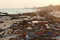
Hurricane Katrina on Gulf Coast.
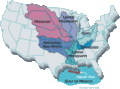
Mississippi river watershed.
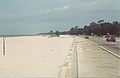
Gulf of Mexico beach.


Credits
New World Encyclopedia writers and editors rewrote and completed the Wikipedia article in accordance with New World Encyclopedia standards. This article abides by terms of the Creative Commons CC-by-sa 3.0 License (CC-by-sa), which may be used and disseminated with proper attribution. Credit is due under the terms of this license that can reference both the New World Encyclopedia contributors and the selfless volunteer contributors of the Wikimedia Foundation. To cite this article click here for a list of acceptable citing formats.The history of earlier contributions by wikipedians is accessible to researchers here:
The history of this article since it was imported to New World Encyclopedia:
Note: Some restrictions may apply to use of individual images which are separately licensed.