File: The Earth seen from Apollo 17.jpg - New World Encyclopedia
The_Earth_seen_from_Apollo_17.jpg (598 × 599 pixels, file size: 120 KB, MIME type: image/jpeg)
This is a file from the Wikimedia Commons. The description on its description page there is shown below.
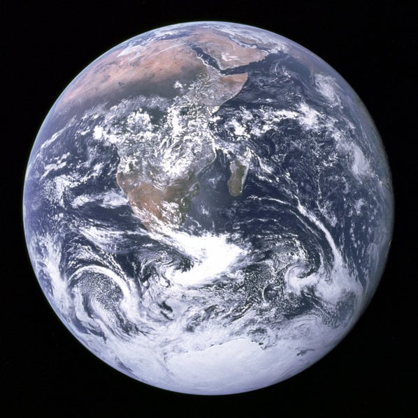
The Blue Marble: This photo is of Africa, Antarctica, and the Arabian Peninsula as taken en route to the Moon by Apollo 17's Harrison Schmitt on December 7, 1972. The flight marked the last time that humans left low Earth orbit and the first and only time a geologist, Harrison Schmitt, travelled to the moon.
This photo is upside-down; in the original photo the south pole is at the top.
The original caption:
View of the Earth as seen by the Apollo 17 crew traveling toward the moon. This translunar coast photograph extends from the Mediterranean Sea area to the Antarctica south polar ice cap. This is the first time the Apollo trajectory made it possible to photograph the south polar ice cap. Note the heavy cloud cover in the Southern Hemisphere. Almost the entire coastline of Africa is clearly visible. The Arabian Peninsula can be seen at the northeastern edge of Africa. The large island off the coast of Africa is the Malagasy Republic. The Asian mainland is on the horizon toward the northeast. This image is a low compression JPEG version of The Earth seen from Apollo 17.png, which itself was taken from NASA [1].
Image courtesy of Earth Sciences and Image Analysis Laboratory, NASA Johnson Space Center. File Name AS17-148-22727
This file is in the public domain because it was created by NASA. NASA copyright policy states that "NASA material is not protected by copyright unless noted". (NASA copyright policy page).
File history
Click on a date/time to view the file as it appeared at that time.
| Date/Time | Thumbnail | Dimensions | User | Comment | |
|---|---|---|---|---|---|
| current | 02:19, 11 January 2006 | | 598 × 599 (120 KB) | Rick Swarts (talk | contribs) |
You cannot overwrite this file.
File usage
The following 21 pages use this file:
- Age of the Earth
- Anthropic principle
- Earth
- Ecology
- Environmentalism
- Escape velocity
- Gaia hypothesis
- Geochemistry
- Holism
- Nature
- Planetary habitability
- Water
- Template:Featured article 2007 36
- Template:Planet Infobox/Earth
- Template:Popular article 08 20
- Template:Popular article 12 27
- Template:Popular article 2008 11
- Template:Popular article 2009 17
- Template:Popular article week 31
- Info:Featured articles
- Test:Popular