File: TOMS indonesia smog lrg.jpg

Original file (1,024 × 768 pixels, file size: 195 KB, MIME type: image/jpeg)
Summary
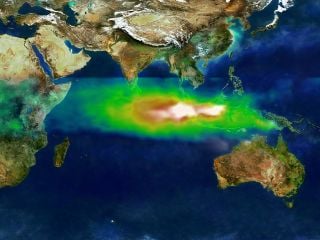
This image shows the pollution over Indonesia and the Indian Ocean on October 22, 1997. White represents the aerosols (smoke) that remained in the vicinity of the fires. Green, yellow, and red pixels represent increasing amounts of tropospheric ozone (smog) being carried to the west by high-altitude winds.
Researchers have discovered that smoke and smog move in different ways through the atmosphere. A series of unusual events several years ago created a blanket of pollution over the Indian Ocean.
In the second half of 1997, smoke from Indonesian fires remained stagnant over Southeast Asia while smog, which is tropospheric, low-level ozone, spread more rapidly across the Indian Ocean toward India.
Researchers tracked the pollution using data from NASA's Earth Probe Total Ozone Mapping Spectrometer (TOMS) satellite instrument. "TOMS is the only satellite instrument that follows both smoke and smog, globally," said Anne Thompson, NASA Earth Scientist at Goddard Space Flight Center, Greenbelt, MD. "The extreme pollution generated during the Indonesian fires was the first time we saw smoke move more slowly and in different directions from where smog moved."
File history
Click on a date/time to view the file as it appeared at that time.
| Date/Time | Thumbnail | Dimensions | User | Comment | |
|---|---|---|---|---|---|
| current | 19:40, 4 May 2008 | | 1,024 × 768 (195 KB) | Rick Swarts (talk | contribs) | Imported from Wikipedia |
You cannot overwrite this file.
File usage
The following page uses this file: